Glay (Doubs)
| Glay | ||
|---|---|---|

|
|
|
| region | Bourgogne-Franche-Comté | |
| Department | Doubs | |
| Arrondissement | Montbeliard | |
| Canton | Maîche | |
| Community association | Pays de Montbéliard agglomeration | |
| Coordinates | 47 ° 24 ' N , 6 ° 53' E | |
| height | 385-566 m | |
| surface | 6.49 km 2 | |
| Residents | 340 (January 1, 2017) | |
| Population density | 52 inhabitants / km 2 | |
| Post Code | 25310 | |
| INSEE code | 25274 | |
 Local government Glay |
||
Glay is a French municipality with 340 inhabitants (as of January 1 2017) in Doubs in the region Bourgogne Franche-Comté .
geography
Glay is located at 398 m , about 14 kilometers southeast of the city of Montbéliard (as the crow flies). The village extends in the northern Jura , at the confluence of the rivers Creuse and Doue to the Gland, in a valley cut into the plateau of the Table Jura , near the border with Switzerland .
The area of the 6.49 km² large municipality covers a section of the northern French Jura. The central part of the area is taken up by the valley cut of the Gland , the bottom of which has a width of about 300 meters. The gland arises with the confluence of the Creuse (from the southwest) and the Doue (from the east) and drains the area north to the Doubs . Several fish ponds were created in the valley floor. These main valleys as well as the Combe de Vaux and other short side valleys are cut at least 100 m deep into the surrounding high plateaus, with the steep slopes predominantly covered with forest.
The surrounding Tafeljura plateaus are formed by Sequan and Kimmeridge limestone and show partly forest, partly arable land and meadows. To the west, the municipality extends to the heights of Pièces Montants ( 519 m ) and Bois de Châtel (up to 552 m). In the south the demarcation lies on the plateau of Mont Beulchy ( 545 m ). In the east, the municipal area includes the southernmost part of the Abbévillers plateau, which averages 540 m, and the valley system of the Doue, which has its source with a karst spring. At 566 m, Glay's highest point is reached on the Pré du Prince corridor on the edge of the Fahy plateau.
In addition to the actual village, Glay also includes the Montaillevey settlements ( 495 m ) on the slope south of the Doue valley, as well as several farms and individual farms. Neighboring communities of Glay are Dannemarie in the south, Blamont and Roches-lès-Blamont in the west, Meslières in the north, Abbévillers in the northeast and the Swiss municipality of Grandfontaine in the east.
history
The first written mention of Glay took place in the 12th century. The village has belonged to the Blamont domain since the Middle Ages. The first church was mentioned as early as the 12th century. It was subject to the ius collationis of the Lanthenans Priory.
After the village came under the sovereignty of the Counts of Montbéliard in 1506, the Lutheran Reformation was introduced in 1540 . With the Augsburg Interim in 1549 , Emperor Charles V placed the church under a Catholic curate . From 1552 Lutheran again devastated in the course of the Eighth Huguenot War in 1587, the Guisen Glay and the Blamont rule. As part of the Blamont rule, which was one of the four dominions of the Principality of Württemberg-Mömpelgard (Montbéliard) and was annexed by France in 1699, Glay came under French rule. The French government expropriated the Lutheran Church in 1699 and appointed a Catholic curate to it. As part of the Blamont rule, Glay came to France under international law in 1748.
The Lutheran village population remained unmarried from their place of worship until the church, which had meanwhile been renewed, was restituted to them in 1792 after the Lutheran creed was recognized. When the number of Catholics increased as a result of immigration, the government ordered in 1804 that the Lutherans open the choir of their church for Catholic masses, while they themselves kept the ship. Finally, the Lutherans built a new church from 1867 to 1869 according to the plans of Jean Frédéric Fallot . So after 65 years they ended the Simultaneum and left the old church to the Catholics.
The first mill on the Doue is mentioned as early as 1385. Businesses that were dependent on water power settled along the two streams early on. Paper mills, oil mills, tanneries and a gemstone cutting shop were all represented in Glay. Towards the end of the 19th century, Glay experienced rapid industrialization, with factories in the field of bicycle, motorcycle and car manufacturing in particular supplementing the traditional branches of the economy. Today the village is part of the Pays de Montbéliard Agglomération municipal association .
Attractions
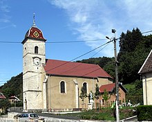
In Glay there is a Lutheran (Église luthérienne) and a Catholic church (St. Peter and Paul). The latter was rebuilt in 1764 and belonged to the Lutheran congregation from 1792 to 1869. The current Lutheran church was built between 1867 and 1869 and is the work of the architect Jean Frédéric Fallot. There are also several fountains from the 19th century and a mill with a water wheel in Glay.
population
| Population development | |
|---|---|
| year | Residents |
| 1962 | 310 |
| 1968 | 314 |
| 1975 | 325 |
| 1982 | 268 |
| 1990 | 307 |
| 1999 | 314 |
| 2004 | 306 |
| 2016 | 341 |
With 340 inhabitants (as of January 1, 2017), Glay is one of the small communities in the Doubs department. As early as 1901, Glay reached its highest level with 646 inhabitants. After that, there was a rapid population decline. Since 1946, the population has always been in the range between 265 and 360 people.
Economy and Infrastructure
As early as the middle of the 19th century, Glay developed into an industrial community. Today there is a company that manufactures accessories for shipbuilding, a metalworking company and local small-scale businesses in the village. Fish farming also has a certain importance. In the meantime, the village has also turned into a residential community. Many workers are therefore commuters who do their work in the Montbéliard agglomeration.
The village is off the main thoroughfares on a departmental road that leads from Hérimoncourt to Blamont. The closest connection to the A36 motorway is around 14 kilometers away. Another road connection exists with Dannemarie.


