
Grandfontaine JU
| JU is the abbreviation for the canton of Jura in Switzerland and is used to avoid confusion with other entries of the name Grandfontaine . |
| Grandfontaine | |
|---|---|
 |
|
| State : |
|
| Canton : |
|
| District : | Porrentruy |
| BFS no. : | 6792 |
| Postal code : | 2908 |
| Coordinates : | 562481 / 249257 |
| Height : | 529 m above sea level M. |
| Height range : | 503–748 m above sea level M. |
| Area : | 8.97 km² |
| Residents: | 395 (December 31, 2018) |
| Population density : | 44 inhabitants per km² |
| Website: | www.grandfontaine.ch |
| Location of the municipality | |
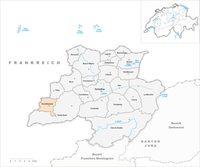  |
|
Grandfontaine is a municipality in the district of Porrentruy in the canton of Jura in Switzerland . The former German name Langenbrunn is no longer used today.
geography

Grandfontaine lies at 529 m above sea level. M. , eleven kilometers west of the district capital Porrentruy (beeline). The farming village extends in a valley of the western Ajoie (German Elsgau ) on the border with France .
The area of the 8.9 km² municipal area includes the wide basin of the dry valley of Grandfontaine in the central part. In the north the area extends to the gently undulating table Jura plateau of the Ajoie, which in the west (outside Switzerland) drops steeply into the valley system of the Gland . To the south, the municipality extends to the wooded heights of La Clef ( 644 m above sea level ) and Le Perchet , as well as in a narrow corner over the dry valley of Réclère to the northern slope of Roche d'Or, where with 740 m above sea level M. the highest point of Grandfontaine is reached. The Grandfontaine area is karstified and has no surface rivers. In 1997, 5% of the municipal area was accounted for by settlements, 30% for forests and woodland and 65% for agriculture.
Several individual farms belong to Grandfontaine. The municipality is surrounded on two sides by French territory. Neighboring communities to Grandfontaine are Haute-Ajoie and Fahy in the canton of Jura and Abbévillers , Glay and Dannemarie in France.
population
With 395 inhabitants (as of December 31, 2018) Grandfontaine is one of the smaller municipalities in the canton of Jura. 91.2% of the residents are French-speaking and 8.5% German-speaking (as of 2000). The population of Grandfontaine was 471 in 1850 and 424 in 1900. In the course of the 20th century, the population decreased by a further 28% to 306 people by 1980. Since then, a slightly increasing trend has been recorded again.
economy
Thanks to the fertile soils in the area, Grandfontaine is still predominantly agricultural. Outside of agriculture, there are local small businesses, a sawmill and the manufacture of watch cases in the village. However, many workers are commuters and work in the Porrentruy region .
traffic
The community is located a little off the cantonal road from Porrentruy across the border crossing from Damvant to Pont-de-Roide-Vermondans in France. The postbus course on the route from Porrentruy to Damvant , which makes a detour to Grandfontaine, means that the place is connected to public transport.
history
The area of Grandfontaine was already settled in Roman times, which the finds of coins confirm. The place is first mentioned in 1136 as Granfontana ; the name is derived from the grande fontaine , a karst spring in the village. Grandfontaine belonged to the Roche-d'Or rule and came to the duchy of Basel towards the end of the 15th century . The village was under the Meieramt Chevenez from the 16th to the 18th century . Three village fires (1756, 1765 and 1785) caused great damage. From 1793 to 1815 Grandfontaine belonged to France and was initially part of the Département du Mont-Terrible , from 1800 connected with the Département Haut-Rhin . By decision of the Congress of Vienna , the place came to the canton of Bern in 1815 and on January 1, 1979 to the newly founded canton of Jura.
Attractions
The parish church of Saint-Étienne stands on a slightly elevated point north of the village center. In the center there are still some characteristic Haute-Ajoie farmhouses from the 19th century. A wash house and a large fountain also date from this period.

Parish Church of Saint-Etienne

Church window

Center of the village, Route de Fontenais
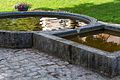
Grande Fontaine (Great Fountain)

Musée agricole (museum)


Web links
- Information about Grandfontaine (French)
- Dominique Prongué: Grandfontaine. In: Historical Lexicon of Switzerland .
Individual evidence
- ↑ Permanent and non-permanent resident population by year, canton, district, municipality, population type and gender (permanent resident population). In: bfs. admin.ch . Federal Statistical Office (FSO), August 31, 2019, accessed on December 22, 2019 .
All | La Baroche | Basse-Allaine | Beurnevésin | Boncourt | Bonfol | Bure | Clos du Doubs | Coeuve | Cornol | Courchavon | Courgenay | Courtedoux | Damphreux | Fahy | Fontenais | Grandfontaine | Haute-Ajoie | Lugnez | Porrentruy | Vendlincourt
Former parishes: Asuel | Bressaucourt | Buix | Charmoille | Chevenez | Courtemaîche | Damvant | Fregiécourt | Miécourt | Montenol | Montignez | Montmelon | Montvoie | Ocourt | Pleujouse | Réclère | Roche-d'Or | Rocourt | Seleute | Saint-Ursanne
Canton of Jura | Districts of the Canton of Jura | Municipalities of the Canton of Jura