
Chevenez
| Chevenez | ||
|---|---|---|
 |
||
| State : |
|
|
| Canton : |
|
|
| District : | Porrentruy | |
| Municipal municipality : | Haute ajoie | |
| Postal code : | 2906 | |
| former BFS no. : | 6780 | |
| Coordinates : | 566885 / 249231 | |
| Height : | 491 m above sea level M. | |
| Area : | 21.73 km² | |
| Residents: | 643 (December 31, 2007) | |
| Population density : | 30 inhabitants per km² | |
| map | ||
|
||


Chevenez ( French [ ʃəvˈnɛː ], in the local dialect [ tövˈneː ]; German Kövenach / Keffenach ) is a village and a former political municipality in the Porrentruy district of the canton of Jura in Switzerland .
geography

Chevenez is 491 m above sea level. M. , six kilometers west-southwest of the district capital Porrentruy (air line). The former street line village extends in a valley basin of the western Ajoie (German Elsgau ), at the northern foot of the Chain Jura .
The area of the 21.7 km² former municipal area includes in the central part the 300 to 500 m wide lowland of the dry valley of Chevenez, which opens to the east to the Allaine . The karst spring Creux-Genat is still on the ground from Chevenez halfway to Porrentruy in this valley , but it only pours water from time to time. In the south, the municipality extends to the Jura ridge of the Lomont chain , over which the border between Switzerland and France runs. Here is the highest elevation of Chevenez with 923 m above sea level. M. The northern side of this chain is heavily forested and has some little valley, but usually do not contain watercourses. The western border is formed by the Fond de Vaux valley , the eastern border is in the Combe Vaillay . To the north of the Chevenez valley, the municipal area extends to the gently south-sloping Tafeljura plateau (up to 615 m above sea level ) of the western Ajoie. The whole area is karstified and shows hardly any surface rivers. In 1997, 3% of the municipal area was accounted for by settlements, 41% for forests and woodlands and 56% for agriculture.
Chevenez owns several individual farms. Neighboring communities of Chevenez were Roche-d'Or , Rocourt , Fahy , Bure , Courtedoux and Bressaucourt in the canton of Jura and Montancy and Glère in neighboring France .
population
With 643 inhabitants (at the end of 2007), Chevenez is one of the medium-sized communities in the canton of Jura. 93.7% of the residents are French-speaking and 4.2% German-speaking (as of 2000). The population of Chevenez was 952 in 1850 and 901 in 1900. In the course of the 20th century a significant decrease in population was registered.
economy
Thanks to the fertile soils in the area, Chevenez is still heavily agricultural . Milk production and the cultivation of grain are of particular importance, and in the past also horse breeding . A machine factory offers jobs in the secondary sector ; in the 19th century the watch industry also had a certain status. Nevertheless, many employed people are commuters who work in the Porrentruy region.
traffic
The former municipality is located on the regional road from Porrentruy to Pont-de-Roide-Vermondans in France. As part of the construction of the A16 motorway , which is to be connected to both the Swiss national road network and the French motorway network by 2015, the Chevenez semi-junction is expected to be built in the far east of the municipality by 2012. The Postbus course on the route from Porrentruy to Damvant means that Chevenez is connected to public transport.
history
Sur Vannez is a fortified spur with finds from the Neolithic Age . The complex, protected on three sides by the natural environment and on the fourth side by a section wall, is the oldest evidence of the settlement of this area. The village was first mentioned as early as 814 as Chaviniacus , then again from the end of the 12th century as Givinei / Chiuini / Chiuene / Chiuenir , and in the 14th century as Cheveney / Zschyveney . The place name is derived from the Latin personal name Cavinius with the Celtic place name suffix -akos / -acum .
Significant lands in the municipality belonged to the Saint-Ursanne monastery . In 1474 Chevenez came to the Principality of Basel . In the 16th century it became the capital of one of the five dairy farms ( mairies ) in the Ajoie. The village was badly affected in the Thirty Years War . During the unrest of 1730–40, the villagers revolted against the prince-bishop's authorities. In the years 1764, 1796 and 1802 village fires caused great damage to the building fabric. From 1793 to 1815 Chevenez belonged to France and was initially part of the Département du Mont-Terrible , from 1800 it was linked to the Département Haut-Rhin . By decision of the Congress of Vienna , the place came to the canton of Bern in 1815 and on January 1, 1979 to the newly founded canton of Jura. With effect from January 1, 2009, the municipality was merged with Damvant , Réclère and Roche-d'Or to form the new municipality of Haute-Ajoie .
Attractions
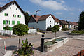
The parish church of Saint-Maurice dates mainly from the period 1841–44, but has retained the polygonal choir from 1632 with a late Gothic main altar from the previous building. In the center there are still numerous typical Ajoie houses from the 17th and 18th centuries. On the western edge of the village is the Notre-Dame-du-Sacré-Cœur chapel, built in 1420 and extensively restored in 1966.
gallery

Saint-Maurice Church

school
Les Colonges
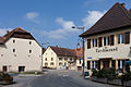
Restaurant du Cheval Blanc

Route de Besançon

Chapel de Notre Dame


Web links
- Information about Chevenez
- Dominique Prongué: Chevenez. In: Historical Lexicon of Switzerland .
Individual evidence
- ↑ a b Nicolas Pépin, Chevenez JU (Porrentruy) in: Dictionnaire toponymique des communes suisses - Lexicon of Swiss community names - Dizionario toponomastico dei comuni svizzeri (DTS | LSG) , Center de dialectologie, Université de Neuchâtel, Verlag Huber, Frauenfeld / Stuttgart / Vienna 2005, ISBN 3-7193-1308-5 and Éditions Payot, Lausanne 2005, ISBN 2-601-03336-3 , p. 243.
All | La Baroche | Basse-Allaine | Beurnevésin | Boncourt | Bonfol | Bure | Clos du Doubs | Coeuve | Cornol | Courchavon | Courgenay | Courtedoux | Damphreux | Fahy | Fontenais | Grandfontaine | Haute-Ajoie | Lugnez | Porrentruy | Vendlincourt
Former parishes: Asuel | Bressaucourt | Buix | Charmoille | Chevenez | Courtemaîche | Damvant | Fregiécourt | Miécourt | Montenol | Montignez | Montmelon | Montvoie | Ocourt | Pleujouse | Réclère | Roche-d'Or | Rocourt | Seleute | Saint-Ursanne
Canton of Jura | Districts of the Canton of Jura | Municipalities of the Canton of Jura