
Fahy
| Fahy | |
|---|---|
 |
|
| State : |
|
| Canton : |
|
| District : | Porrentruy |
| BFS no. : | 6789 |
| Postal code : | 2916 |
| UN / LOCODE : | CH FHY |
| Coordinates : | 563 233 / 252187 |
| Height : | 567 m above sea level M. |
| Height range : | 555–613 m above sea level M. |
| Area : | 7.78 km² |
| Residents: | 350 (December 31, 2018) |
| Population density : | 45 inhabitants per km² |
| Website: | fahy.ch |
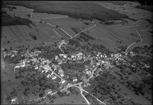
| Location of the municipality | |
  |
|
Fahy is a municipality in the Porrentruy district in the canton of Jura in Switzerland .
geography
Fahy lies at 567 m above sea level. M. , 9 km west of the district capital Porrentruy (air line). The farming village on the border with France extends on the plateau of the Table Jura in the west of the Ajoie (German Elsgau ).
The surface of the 7.8 km² municipal area includes the slightly undulating, karstified high plateau of the Ajoie, which shows no surface rivers. The northern part of the area is partially forested ( Bois Juré and Bois de la Manche ). At the height of Sur l'Epenatte is at 607 m above sea level. M. the highest elevation in the community. In 1997, 9% of the municipal area was settlements, 26% forest and woodland, 57% agriculture and around 8% was unproductive land belonging to the Bure arsenal.
Several individual farms belong to Fahy. Neighboring communities of Fahy are Grandfontaine , Haute-Ajoie and Bure in the canton of Jura and Abbévillers and Croix in neighboring France .
Climate table
| Fahy, 1981-2010 | ||||||||||||||||||||||||||||||||||||||||||||||||
|---|---|---|---|---|---|---|---|---|---|---|---|---|---|---|---|---|---|---|---|---|---|---|---|---|---|---|---|---|---|---|---|---|---|---|---|---|---|---|---|---|---|---|---|---|---|---|---|---|
| Climate diagram | ||||||||||||||||||||||||||||||||||||||||||||||||
| ||||||||||||||||||||||||||||||||||||||||||||||||
|
Average monthly temperatures and rainfall for Fahy, 1981–2010
Source:
|
||||||||||||||||||||||||||||||||||||||||||||||||||||||||||||||||||||||||||||||||||||||||||||||||||||||||||||||||||||||||||||||||||||||||||||||||||||||||||||||||||||||||||||||||||||
population
With 350 inhabitants (as of December 31, 2018) Fahy is one of the smaller communities in the canton of Jura. 95.6% of the residents are French-speaking, 1.8% German-speaking and 1.5% Italian-speaking (as of 2000). The population of Fahy was 549 in 1850, and 492 in 1900. Thereafter there were only minor changes until 1970 (501 inhabitants). Since then there has been a significant decrease.
economy
Fahy was a predominantly agricultural village until around 1950 . Since then, several companies have settled here, including Peugeot , which is responsible for the entire import of Peugeot vehicles into Switzerland. There are other jobs in the manufacture of watches , in the mechanical, textile and food industries as well as in border trade. Thanks to the fertile soil, agriculture is still of great importance today.
traffic
The community is very well developed in terms of transport. It is located on the main road from Porrentruy via the border crossing Fahy to Montbéliard in France. Fahy is connected to public transport through a postbus course to Porrentruy.
history
The place is first mentioned in 1177 as Fahyl , in 1483 the spelling Fahyt appears . The place name is derived from the Latin word fagus ( beech ). In 1461 Fahy came to the Principality of Basel . During the Burgundian Wars , the village was almost completely leveled twice in 1474 and 1475. From the 16th to the 18th century the village was under the Meieramt Bure . From 1793 to 1815 Fahy belonged to France and was initially part of the Département du Mont-Terrible , from 1800 it was linked to the Département Haut-Rhin . By decision of the Congress of Vienna , the place came to the canton of Bern in 1815 and on January 1, 1979 to the newly founded canton of Jura.
Attractions
Fahy belonged to the parish of Grandfontaine until 1802 , after which the Saint-Pierre church, built in 1787-88, was elevated to a parish church. In the center of the village there are some characteristic Haute-Ajoie farmhouses from the 19th century. Until the beginning of the 20th century, the water was extracted using a draw well.
photos
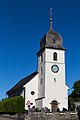
church

Meetinghouse and multipurpose hall
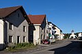
Route de Porrentruy

Primary school building
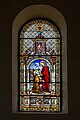
Church window


Web links
- Information about Fahy (French)
- Dominique Prongué: Fahy. In: Historical Lexicon of Switzerland .
Individual evidence
- ↑ Permanent and non-permanent resident population by year, canton, district, municipality, population type and gender (permanent resident population). In: bfs. admin.ch . Federal Statistical Office (FSO), August 31, 2019, accessed on December 22, 2019 .
- ↑ Climate table. In: meteoschweiz.admin.ch. meteoschweiz, accessed on May 31, 2018 .
All | La Baroche | Basse-Allaine | Beurnevésin | Boncourt | Bonfol | Bure | Clos du Doubs | Coeuve | Cornol | Courchavon | Courgenay | Courtedoux | Damphreux | Fahy | Fontenais | Grandfontaine | Haute-Ajoie | Lugnez | Porrentruy | Vendlincourt
Former parishes: Asuel | Bressaucourt | Buix | Charmoille | Chevenez | Courtemaîche | Damvant | Fregiécourt | Miécourt | Montenol | Montignez | Montmelon | Montvoie | Ocourt | Pleujouse | Réclère | Roche-d'Or | Rocourt | Seleute | Saint-Ursanne
Canton of Jura | Districts of the Canton of Jura | Municipalities of the Canton of Jura