
Courtedoux
| Courtedoux | |
|---|---|
 |
|
| State : |
|
| Canton : |
|
| District : | Porrentruy |
| BFS no. : | 6785 |
| Postal code : | 2905 |
| Coordinates : | 570 145 / 251066 |
| Height : | 470 m above sea level M. |
| Height range : | 433–631 m above sea level M. |
| Area : | 8.21 km² |
| Residents: | 765 (December 31, 2018) |
| Population density : | 93 inhabitants per km² |
| Website: | www.courtedoux.ch |
 Courtedoux |
|
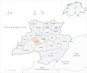
| Location of the municipality | |
  |
|
Courtedoux is a municipality in the Porrentruy district in the canton of Jura in Switzerland . The former German name Ludolfsdorf is no longer used today.
geography
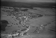
Courtedoux is 470 m above sea level. M. , 2.5 km west-southwest of the district capital Porrentruy (air line). The village extends on a terrace north of the Creugenat valley, in the Ajoie (German Elsgau ), at the northern foot of the Chain Jura .
The area of the 8.1 km² municipal area includes in the southern section the partly wide lowland of the dry valley of Creux-Genat . The Creugenat is a karst spring , which in the field of Chevenez is only about four to five times a year on average pours water. In the north-west, the municipality extends up the gently sloping and partly wooded slope up to the Table Jura plateau of Bure. Here is on the Haut du Mont at 630 m above sea level. M. the highest point of Courtedoux. In 1997, 7% of the municipal area was accounted for by settlements, 39% for forests and woodlands and 54% for agriculture.
Several individual farms belong to Courtedoux. Courtedoux's neighboring municipalities are Porrentruy , Bressaucourt , Chevenez and Bure .
population
With 765 inhabitants (as of December 31, 2018), Courtedoux is one of the medium-sized communities in the canton of Jura. 95.9% of the residents are French-speaking, 2.4% German-speaking and 0.5% Portuguese-speaking (as of 2000). The population of Courtedoux was 499 in 1850 and 759 in 1900. In the course of the 20th century, the population always fluctuated between 590 and 720 people.
economy
Courtedoux is still agricultural today thanks to the fertile soils in the area . Since the middle of the 20th century, the village has gradually transformed into a residential community. Outside of agriculture, there are some jobs in local small businesses. Many employed people are commuters and work in nearby Porrentruy.
traffic
The community is very well developed in terms of transport. The main road from Porrentruy to Montbéliard or Pont-de-Roide-Vermondans in France leads through the Creugenat Valley . The A16 motorway is expected to run through the municipality from 2012 and will be connected to both the Swiss national road network and the French motorway network by 2015. Courtedoux is connected to public transport by the postbus course from Porrentruy to Damvant . In 1946 the Porrentruy airfield was built on the valley floor on the border between Courtedoux and Porrentruy . It was relocated as the Bressaucourt airfield on the Echaux near Bressaucourt .
history
The place was mentioned as early as 814 as Curtis Udulphi owned by the Saint-Ursanne monastery . The name goes back to the farm of a man with the Germanic name Udulf . In 1139 the name Curtedul appears in a document from Pope Innocent II. In the 13th century, Courtedoux came to the Principality of Basel . From the 16th to the 18th century it was the main town of the Meieramt ( mairie ) of the same name . During the Thirty Years War , the village was badly affected. From 1793 to 1815 Courtedoux belonged to France and was initially part of the Département du Mont-Terrible , from 1800 connected with the Département Haut-Rhin . By decision of the Congress of Vienna , the place came to the canton of Bern in 1815 and on January 1, 1979 to the newly founded canton of Jura.
Attractions
The parish church of Saint-Martin was rebuilt in 1835. In the town center there are still some typical 19th century farmhouses.
During the preparatory work for the construction of the A16 motorway, numerous dinosaur tracks were discovered and uncovered on a limestone slab near Courtedoux . These traces were made around 150 million years ago when the area on the northern edge of the ancient Mediterranean Sea, Tethys, was populated by dinosaurs.
gallery
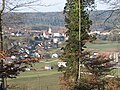
View of Courtedoux

Saint Martin Church

Schoolhouse, municipal administration

Rue du Collège
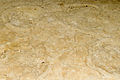
Dinosaur tracks

Spinning top (pruntrut)


Web links
- Information about Courtedoux (French)
- Dominique Prongué: Courtedoux. In: Historical Lexicon of Switzerland .
Individual evidence
- ↑ Permanent and non-permanent resident population by year, canton, district, municipality, population type and gender (permanent resident population). In: bfs. admin.ch . Federal Statistical Office (FSO), August 31, 2019, accessed on December 22, 2019 .
- ↑ Dinosaur tracks near Courtedoux (with pictures, French) ( Memento of September 29, 2007 in the Internet Archive )
All | La Baroche | Basse-Allaine | Beurnevésin | Boncourt | Bonfol | Bure | Clos du Doubs | Coeuve | Cornol | Courchavon | Courgenay | Courtedoux | Damphreux | Fahy | Fontenais | Grandfontaine | Haute-Ajoie | Lugnez | Porrentruy | Vendlincourt
Former parishes: Asuel | Bressaucourt | Buix | Charmoille | Chevenez | Courtemaîche | Damvant | Fregiécourt | Miécourt | Montenol | Montignez | Montmelon | Montvoie | Ocourt | Pleujouse | Réclère | Roche-d'Or | Rocourt | Seleute | Saint-Ursanne
Canton of Jura | Districts of the Canton of Jura | Municipalities of the Canton of Jura