
Cornol
| Cornol | |
|---|---|
 |
|
| State : |
|
| Canton : |
|
| District : | Porrentruy |
| BFS no. : | 6782 |
| Postal code : | 2952 |
| Coordinates : | 579264 / 250718 |
| Height : | 520 m above sea level M. |
| Height range : | 462–933 m above sea level M. |
| Area : | 10.45 km² |
| Residents: | 1010 (December 31, 2018) |
| Population density : | 97 inhabitants per km² |
| Website: | www.cornol.ch |
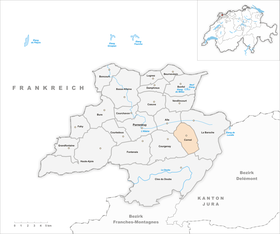
 Cornol |
|
| Location of the municipality | |
  |
|
Cornol is a municipality in the Porrentruy district in the canton of Jura in Switzerland . The former German name Gundelsdorf is no longer used today.
geography

Cornol lies at 520 m above sea level. M. , 7 km east of the district capital Porrentruy (air line). The former street and stream line village extends along the Cornoline stream in the Ajoie (German Elsgau ), at the northern foot of the Chain Jura .
The area of the 10.4 km² municipal area includes in the northern section the wide plain of La Pran , which slopes slightly to the north and is traversed by the Cornoline, a side stream of the Allaine . In the southern part, the community area extends into the headwaters of the Cornoline on the northern slope of the Lomont Jura range . In this upper part the brook forms a gorge-like valley between the heights of Mont Terri ( 804 m above sea level ) in the west and the Ecré ( 649 m above sea level ) in the east. The highest point of the community is 940 m above sea level. M. on the ridge of the Lomont chain. In 1997, 7% of the municipal area was in settlements, 34% in forests and woodland, 58% in agriculture and less than 1% was unproductive land.
Numerous individual farms belong to Cornol. Cornol's neighboring municipalities are Courgenay , Alle , La Baroche and Clos du Doubs .
population
With 1010 inhabitants (as of December 31, 2018), Cornol is one of the medium-sized communities in the canton of Jura. 93.1% of the residents are French-speaking, 3.6% German-speaking and 1.1% Italian-speaking (as of 2000). Cornol's population peaked at the end of the 19th century. After that, a significant decline was recorded until 1930. In the further course of the 20th century there was comparatively little population fluctuation.
economy
| Population development | |
|---|---|
| year | Residents |
| 1850 | 786 |
| 1900 | 1,145 |
| 1910 | 1,030 |
| 1930 | 789 |
| 1950 | 831 |
| 1960 | 809 |
| 1970 | 855 |
| 1980 | 708 |
| 1990 | 769 |
| 2000 | 797 |
Cornol developed from an agricultural and industrial village in the 19th century. Pottery gained importance in the 18th century and continued to develop in the 19th century. At this time, the watch industry , the mining of gypsum and iron smelting were added. Today the local population is mainly active in local small businesses. Thanks to the fertile soils in the area, agriculture is still very important today.
The tourist infrastructure is limited to measures and facilities that were developed independently, such as a network of hiking trails and a swing golf course .
traffic
The community has good transport links. It is located on the main road from Porrentruy over the Les Rangiers pass to Delémont . The section of the A16 motorway from Delémont to Porrentruy, which was opened in 1998 and which is to be connected to both the Swiss national road network and the French motorway network by 2015, runs through the western municipal area . The Courgenay exit and the north portal of the 4 km long Mont Terri tunnel are on the Cornol floor. Since opening, the through traffic through the village has decreased significantly. The Postbus course from Porrentruy to Asuel connects Cornol to public transport.
history
Cornol can look back on a very long tradition of settlement. The Mont Terri had since the Neolithic period a fortified settlement site, other findings that were discovered in a cave near the village, can be attributed to the late Bronze Age date. The Celts established the oppidum here on Mont Terri .
The village is first mentioned in 1136 as Coronotum , later the names Coronolt (1180) and Corenol (1406) appear. Cornol came to the Principality of Basel for the first time in 1271 . From the 16th to the 18th century it belonged to the Meieramt Alle . During the unrest from 1730 to 1740, the villagers revolted against the prince-bishop's authorities. From 1793 to 1815, Cornol belonged to France and was initially part of the Département du Mont-Terrible , from 1800 it was linked to the Département Haut-Rhin . By decision of the Congress of Vienna , the place came to the canton of Bern in 1815 and on January 1, 1979 to the newly founded canton of Jura.
Attractions
The first parish church in Cornol was the Saint-Julien chapel, renamed Saint-Gilles after the Thirty Years War and rebuilt in 1699. It stands far outside the village at the foot of Mont Terri on the site of the former village of Courtemblin, which was destroyed during the Thirty Years War and not rebuilt afterwards. When the new Saint-Vincent church was built in the town center from 1785–87, it received the status of parish church. An imposing building is the restaurant du Lion d'Or (To the Golden Lion) from the 18th century. In the center there are still numerous typical farmhouses from the 18th and 19th centuries. The Saint-Wendelin chapel, which was built in 1870, is located on the eastern slope of Mont Terri. In the forest of Montoie is the idyllically situated Étang de Montoie , which also serves as a fish pond .
gallery

Parish Church of Saint Vincent
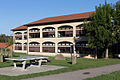
Primary school building
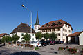
Rectory, church and parish administration
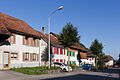
Route of the shunting
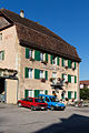
Lion d'Or restaurant

Saint-Gilles Chapel


Web links
- Official website of the municipality of Cornol
- Information about Cornol (French)
- Dominique Prongué: Cornol. In: Historical Lexicon of Switzerland .
Individual evidence
- ↑ Permanent and non-permanent resident population by year, canton, district, municipality, population type and gender (permanent resident population). In: bfs. admin.ch . Federal Statistical Office (FSO), August 31, 2019, accessed on December 22, 2019 .
All | La Baroche | Basse-Allaine | Beurnevésin | Boncourt | Bonfol | Bure | Clos du Doubs | Coeuve | Cornol | Courchavon | Courgenay | Courtedoux | Damphreux | Fahy | Fontenais | Grandfontaine | Haute-Ajoie | Lugnez | Porrentruy | Vendlincourt
Former parishes: Asuel | Bressaucourt | Buix | Charmoille | Chevenez | Courtemaîche | Damvant | Fregiécourt | Miécourt | Montenol | Montignez | Montmelon | Montvoie | Ocourt | Pleujouse | Réclère | Roche-d'Or | Rocourt | Seleute | Saint-Ursanne
Canton of Jura | Districts of the Canton of Jura | Municipalities of the Canton of Jura