
Courtemaîche
| Courtemaîche | ||
|---|---|---|
 |
||
| State : |
|
|
| Canton : |
|
|
| District : | Porrentruy | |
| Municipal municipality : | Basse-Allaine | |
| Postal code : | 2923 | |
| former BFS no. : | 6786 | |
| Coordinates : | 570488 / 256624 | |
| Height : | 398 m above sea level M. | |
| Area : | 8.94 km² | |
| Residents: | 630 (December 31, 2007) | |
| Population density : | 70 inhabitants per km² | |
| Website: | www.courtemaiche.ch | |
| map | ||
|
||


Courtemaîche ( French [ kuʀtəmɛʃ ], in the local dialect [ (a) kwɛʧˈmɛːʧ ]) is a village and a former political municipality in the district of Porrentruy in the canton of Jura in Switzerland .
geography
Courtemaîche is 398 m above sea level. M. , five kilometers north-northwest of the district capital Porrentruy (air line). The village extends slightly higher on the western edge of the Allaine valley , in the Ajoie (German Elsgau ).
The area of the 8.9 km² former municipal area includes in the central part the up to 700 m wide valley of the Allaine, which is sunk into the Ajoie plateau . In the east, the area extends to the ridge (at Les Moncovets 527 m above sea level ) between the Allaine and the Coeuvatte , which is predominantly forest. To the west, the municipality extended to the height of Bure and reached on the Tcherteau at 612 m above sea level. M. the highest point of Courtemaîche. From this height several small valleys open towards the Allaine. In 1997, 8% of the municipal area was settled, 52% forest and woodland, 38% agriculture and about 2% was unproductive land belonging to the Bure arsenal.
Courtemaîche includes the houses of the hamlet of Grandgourt ( 389 m above sea level ) on the left of the Allaine, as well as several individual farms. Courtemaîche's neighboring municipalities were Bure , Buix , Montignez , Damphreux , Coeuve and Courchavon .
population
With 630 inhabitants (at the end of 2007), Courtemaîche is one of the medium-sized communities in the canton of Jura. 93.7% of the residents are French-speaking, 5.1% German-speaking and 0.8% Portuguese-speaking (as of 2000). The population of Courtemaîche was 426 in 1850 and 680 in 1900. After a peak around 1910 with 779 inhabitants, a downward trend was recorded over the course of the 20th century.
economy
Courtemaîche is still dominated by agriculture . Since the middle of the 20th century, some residential areas have been built. Outside of agriculture, there are some jobs in local small businesses (gear assembly, watch case grinding). Many employed people are commuters and work in Porrentruy or in Boncourt .
traffic
Courtemaîche is located on the busy main road from Porrentruy via the Boncourt border crossing to Belfort or Montbéliard in France . When the A16 motorway , which is to be connected to both the Swiss national road network and the French motorway network by 2015, is expected to open from Boncourt to Porrentruy in 2012 , the village should be relieved of through traffic. On September 23, 1872 by the PD the railway Porrentruy-Delle opened with a station in Courtemaîche. However, this is located a bit outside the village on the other side of the Allaine valley. From Courtemaîche a railway branch line was built for military transports to the Bure Armory, which was opened on March 19, 1968.
history
The area of the Allaine valley, which has numerous large and small caves , was already populated during the Neolithic and the Iron Age. Traces of settlement from this period were found in the caves of La Bâme near Courtemaîche.
The village is mentioned several times in the 12th century as Cordemasche / Cordomache / Cordemacha / Cordomasge . The place name is probably a combination of Rom. Corte 'Hof, Landgut, Weiler' and a Germanic personal name * Domaska . Courtemaîche shared the checkered history of the Ajoie, which came to the Principality of Basel for the first time in 1271 . The village was under the Meieramt Bure from the 16th to the 18th century . The place was sacked during the Thirty Years' War . From 1793 to 1815 Courtemaîche belonged to France and was initially part of the Département du Mont-Terrible , from 1800 connected with the Département Haut-Rhin . By decision of the Congress of Vienna , the place came to the canton of Bern in 1815 and on January 1, 1979 to the newly founded canton of Jura. The municipality was merged with Buix and Montignez to form the new municipality of Basse-Allaine with effect from January 1, 2009 .
Attractions
The parish church of Saint-Timothée-et-Saint-Symphorien was rebuilt in 1855 in neoclassical style on the site of a previous building from 1627. In the center of the village, the typical farms from the 19th century form an architectural unit. The former estate of the de Couthenans family dates back to 1530. To the north of the village is the late Gothic chapel of Saint-Symphorien.

center
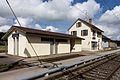
railway station

church

school

View to the village


Personalities
The SP politician Helmut Hubacher (1926-2020) lived with his wife Gret in Courtemaîche.
Web links
- Dominique Prongué: Courtemaîche. In: Historical Lexicon of Switzerland .
- Official website of the Municipality of Courtemaîche
- Information about Courtemaîche (French, archive)
Individual evidence
- ↑ a b Nicolas Pépin, Courtemaîche JU (Porrentruy) in: Dictionnaire toponymique des communes suisses - Lexicon of Swiss community names - Dizionario toponomastico dei comuni svizzeri (DTS | LSG) , Center de dialectologie, Université de Neuchâtel, Verlag Huber, Frauenfeld / Stuttgart / Vienna 2005, ISBN 3-7193-1308-5 and Éditions Payot, Lausanne 2005, ISBN 2-601-03336-3 , p. 273f.
All | La Baroche | Basse-Allaine | Beurnevésin | Boncourt | Bonfol | Bure | Clos du Doubs | Coeuve | Cornol | Courchavon | Courgenay | Courtedoux | Damphreux | Fahy | Fontenais | Grandfontaine | Haute-Ajoie | Lugnez | Porrentruy | Vendlincourt
Former parishes: Asuel | Bressaucourt | Buix | Charmoille | Chevenez | Courtemaîche | Damvant | Fregiécourt | Miécourt | Montenol | Montignez | Montmelon | Montvoie | Ocourt | Pleujouse | Réclère | Roche-d'Or | Rocourt | Seleute | Saint-Ursanne
Canton of Jura | Districts of the Canton of Jura | Municipalities of the Canton of Jura