
Bure JU
| JU is the abbreviation for the canton of Jura in Switzerland and is used to avoid confusion with other entries of the name Bure . |
| Bure | |
|---|---|
 |
|
| State : |
|
| Canton : |
|
| District : | Porrentruy |
| BFS no. : | 6778 |
| Postal code : | 2915 |
| Coordinates : | 567 440 / 254787 |
| Height : | 587 m above sea level M. |
| Height range : | 488–638 m above sea level M. |
| Area : | 13.68 km² |
| Residents: | 659 (December 31, 2018) |
| Population density : | 48 inhabitants per km² |
| Website: | www.bure.ch |
| Location of the municipality | |
  |
|
Bure is a municipality in the Pruntrut district in the canton of Jura in Switzerland . The former German name Burnen is no longer used today.
geography
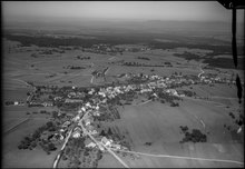
Bure is 587 m above sea level. M. , 6 km northwest of the district capital Pruntrut (air line). The farming village extends on the Tafeljura plateau of western Ajoie (German Elsgau ), near the border with France .
The area of the 13.7 km² municipal area includes the open, slightly undulating plateau of the Ajoie west of the Allaine valley. The highest point in the municipality is on the Haut Mont ( 633 m above sea level ). Larger forests ( Le Rondat and Bois de Bure ) occupy the west of the municipality . To the north the landscape sinks to the hollow of the dry valley Grande Valle . In 1997, 9% of the municipal area was settled, 29% forest and woodland, 52% agriculture and almost 10% was unproductive land, which is part of the Bure arsenal.
The hamlet of Le Paradis , 618 m above sea level, belongs to Bure . M. on a hill on the border with France, and several individual farms. Neighboring municipalities of Bure are Basse-Allaine , Courchavon , Porrentruy , Courtedoux , Haute-Ajoie and Fahy in the canton of Jura and Croix and Villars-le-Sec in neighboring France.
population
With 659 inhabitants (as of December 31, 2018), Bure is one of the medium-sized communities in the canton of Jura. 98.0% of the residents are French-speaking, 1.9% German-speaking and 0.1% Italian-speaking (as of 2000). The population of Bure was 798 in 1850 and 607 in 1900. In the course of the 20th century, the population always fluctuated between 560 and 680 people.
economy

Bure is still characterized by agriculture thanks to the fertile soils in the area . In 1968 the Bure army arsenal was opened, the establishment of which was previously highly controversial. The military facilities now offer jobs to a large number of residents, so that the emigration trend has largely been stopped. There are also some jobs in local small businesses.
traffic
The community is located away from the through streets. As part of the construction of the A16 motorway , which is to be linked to both the Swiss national road network and the French motorway network by 2015, a junction is expected to be built just north of Bure by 2012. The village itself and the height of Bure are crossed under a 3 km long tunnel. Bure is connected to public transport by a postbus course that runs from Porrentruy to Fahy.
Although there is a railway line from Courtemaîche to Bure , which connects the Bure Gun Square with the Delémont – Delle railway line, there is no public transport on this line.
history
The village is mentioned for the first time as Bures in 1139 in a document from Pope Innocent II , who confirmed the property of the Saint-Ursanne monastery in Bure. In the following years the names Bür , Burn (1236) and Burris (1461) also appear. Bure shared the checkered history of the Ajoie, which first came to the Duchy of Basel in 1271 . From the 16th to the 18th century, the village was the main town of the Meieramtes of the same name ( mairie ). During the Thirty Years War the village was affected. From 1793 to 1815, Bure belonged to France and was initially part of the Département du Mont-Terrible , from 1800 connected with the Département Haut-Rhin . By decision of the Congress of Vienna , the place came to the canton of Bern in 1815 and on January 1, 1979 to the newly founded canton of Jura.
Attractions
The parish church of Saint-Armand mainly dates from 1681 to 1683, but still has the tower of the previous building from 1454. The main altar from 1733 is the work of the Breton brothers from Boncourt . The former rectory, which was built in 1749, adjoins the church to the south. The Notre-Dame-des-Ermites votive chapel, built in 1860 and renovated in 1971, is located in the hamlet of Le Paradis.
photos

church

Church window

Parish hall

school

Cantonale route


Web links
- Official website of the municipality of Bure (French)
- Dominique Prongué: Bure. In: Historical Lexicon of Switzerland .
Individual evidence
- ↑ Permanent and non-permanent resident population by year, canton, district, municipality, population type and gender (permanent resident population). In: bfs. admin.ch . Federal Statistical Office (FSO), August 31, 2019, accessed on December 22, 2019 .
All | La Baroche | Basse-Allaine | Beurnevésin | Boncourt | Bonfol | Bure | Clos du Doubs | Coeuve | Cornol | Courchavon | Courgenay | Courtedoux | Damphreux | Fahy | Fontenais | Grandfontaine | Haute-Ajoie | Lugnez | Porrentruy | Vendlincourt
Former parishes: Asuel | Bressaucourt | Buix | Charmoille | Chevenez | Courtemaîche | Damvant | Fregiécourt | Miécourt | Montenol | Montignez | Montmelon | Montvoie | Ocourt | Pleujouse | Réclère | Roche-d'Or | Rocourt | Seleute | Saint-Ursanne
Canton of Jura | Districts of the Canton of Jura | Municipalities of the Canton of Jura