
Montenol
| Montenol | ||
|---|---|---|
 |
||
| State : |
|
|
| Canton : |
|
|
| District : | Porrentruy | |
| Municipal municipality : | Clos du Doubs | |
| Postal code : | 2884 | |
| former BFS no. : | 6795 | |
| Coordinates : | 578 193 / 244545 | |
| Height : | 692 m above sea level M. | |
| Area : | 2.15 km² | |
| Residents: | 86 (December 31, 2007) | |
| Population density : | 40 inhabitants per km² | |
| map | ||
|
||


Montenol ( French [ mõtnɔl ], in the local dialect [ (ɛ) mɶ̃tˈno ]) is a village and a former political municipality in the Porrentruy district of the Swiss canton of Jura .
geography
Montenol is 692 m above sea level. M. , nine kilometers southeast of the district capital Porrentruy (air line). The farming village stretched at the height of a Jura ridge , which is surrounded on three sides by the deeply cut Doubs , directly above Saint-Ursanne .
The area of the former municipal area of just 2.2 km² includes a section of the anticlines of the Clos du Doubs with the height of Montenol and the partly rocky, forest-covered Chêtelat , which at 841 m above sea level. M. forms the highest point of the former municipality. In the far west the area extends to the slope of the Fin du Teck . In 1997, 3% of the municipal area was accounted for by settlements, 33% for forests and woodlands and 64% for agriculture.
Several individual farms belonged to Montenol. The neighboring communities of Montenol were Saint-Ursanne , Montmelon and Epauvillers .
population
With 86 inhabitants (at the end of 2007), Montenol was one of the smallest communities in the canton of Jura. 98.8% of the residents are French-speaking, 1.2% Spanish-speaking (as of 2000). The population of Montenol was 103 inhabitants in 1860 and 59 inhabitants in 1900. In the course of the 20th century, the population always fluctuated between 50 and 80 people.
economy
Montenol is a village dominated by agriculture , with livestock and dairy farming predominating. The place does not offer any jobs outside the primary sector. The few gainfully employed people who do not work in agriculture mainly work in the valley town of Saint-Ursanne.
traffic
Montenol is a bit off the cantonal road from Saint-Ursanne to Soubey . There is a postbus course on this route that connects the village to public transport.
history

The village was first mentioned in 1173 as Montenot . The place name is composed of mont 'Berg' and a Germanic personal name, possibly Hunwald / Hunold / Hanolt . Montenol was under the provost of Saint-Ursanne. From 1793 to 1815, Montenol belonged to France and was initially part of the Département du Mont-Terrible , from 1800 connected with the Département Haut-Rhin . Through the decision of the Congress of Vienna , the place came to the Canton of Bern in 1815 . In 1865, numerous houses fell victim to a village fire. On January 1, 1979, the community came to the newly founded Canton of Jura; on January 1, 2009 it was combined with Epauvillers , Epiquerez , Montmelon , Ocourt , Saint-Ursanne and Seleute to form the new municipality of Clos du Doubs .
Attractions
Traditional farmhouses from the 19th century stand on both sides of the only village street. The Notre-Dame-de-Lourdes chapel was built at the beginning of the 19th century and later renovated several times.
photos

Farmhouses

Farmhouses
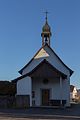
chapel

farm

former schoolhouse


Web links
- Dominique Prongué: Montenol. In: Historical Lexicon of Switzerland .
- Information on the municipality of Montenol (French)
Individual evidence
- ↑ a b Florence Cattin, Montenol JU (Porrentruy) in: Dictionnaire toponymique des communes suisses - Lexicon of Swiss community names - Dizionario toponomastico dei comuni svizzeri (DTS | LSG) , Center de dialectologie, Université de Neuchâtel, Verlag Huber, Frauenfeld / Stuttgart / Vienna 2005, ISBN 3-7193-1308-5 and Éditions Payot, Lausanne 2005, ISBN 2-601-03336-3 , p. 609
All | La Baroche | Basse-Allaine | Beurnevésin | Boncourt | Bonfol | Bure | Clos du Doubs | Coeuve | Cornol | Courchavon | Courgenay | Courtedoux | Damphreux | Fahy | Fontenais | Grandfontaine | Haute-Ajoie | Lugnez | Porrentruy | Vendlincourt
Former parishes: Asuel | Bressaucourt | Buix | Charmoille | Chevenez | Courtemaîche | Damvant | Fregiécourt | Miécourt | Montenol | Montignez | Montmelon | Montvoie | Ocourt | Pleujouse | Réclère | Roche-d'Or | Rocourt | Seleute | Saint-Ursanne
Canton of Jura | Districts of the Canton of Jura | Municipalities of the Canton of Jura