
Damphreux
| Damphreux | |
|---|---|
 |
|
| State : |
|
| Canton : |
|
| District : | Porrentruy |
| BFS no. : | 6787 |
| Postal code : | 2933 |
| Coordinates : | 574 685 / 258457 |
| Height : | 420 m above sea level M. |
| Height range : | 415-525 m above sea level M. |
| Area : | 5.67 km² |
| Residents: | 176 (December 31, 2018) |
| Population density : | 31 inhabitants per km² |
| Website: | www.damphreux.ch |
| Location of the municipality | |
  |
|
Damphreux is a municipality in the Porrentruy district in the canton of Jura in Switzerland .
geography

Damphreux lies at 420 m above sea level. M. , 7 km north of the district capital Porrentruy (air line). The farming village extends in the valley of the Coeuvatte and on the adjacent slopes, in the northern Ajoie (German Elsgau ).
The area of the 5.6 km² municipal area covers part of the gently undulating table Jura landscape in the north of the Ajoie, which is traversed by the winding valley of the Coeuvatte. In the east the area extends to the height of Les Côtaies ( 479 m above sea level ), in the north in the forest of La Vouevre . To the west, the municipality extends over the height of Mohé into the forest Le Bonné , which is 525 m above sea level. M. forms the highest point of Damphreux. The area is drained by the Coeuvatte to the Allaine . In 1997, 3% of the municipal area was in settlements, 32% in forests and woodlands, 64% in agriculture and 1% was unproductive land.
Several individual farms belong to Damphreux. Neighboring municipalities to Damphreux are Lugnez , Beurnevésin , Bonfol , Vendlincourt , Coeuve and Basse-Allaine .
population
With 176 inhabitants (as of December 31, 2018) Damphreux is one of the small communities in the canton of Jura. 86.8% of the residents are French-speaking, 11.5% German-speaking and 0.6% Italian-speaking (as of 2000). The population of Damphreux was 344 in 1850 and 294 in 1900. Since then it has continuously decreased.
economy
Damphreux is still predominantly agricultural and has extensive fertile soils. Outside of agriculture there are only a few jobs in the village. Many workers are therefore commuters and work in Porrentruy or in Boncourt .
traffic
The municipality is located on a regional road that leads from Porrentruy through Coeuve and Damphreux to France . Damphreux is connected to public transport through a postbus course that runs from Porrentruy to Beurnevésin .
history
The place is first mentioned in 1161 as Damfriol . The names Dunfriol (1178) and Damphriol (1256) followed later . The name goes back to the Apostle Ferréol of the Sequaner and means place of residence of Ferréol . The Moutier-Grandval provost and the Saint-Ursanne monastery owned land in the municipality . Damphreux shared the checkered history of Ajoie, which came to the Principality of Basel for the first time in 1271 . From the 16th to the 18th century, the village was under the Meieramt Coeuve . From 1793 to 1815 Damphreux belonged to France and was initially part of the Département du Mont-Terrible , from 1800 connected with the Département Haut-Rhin . By decision of the Congress of Vienna , the place came to the canton of Bern in 1815 and on January 1, 1979 to the newly founded canton of Jura.
Attractions
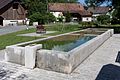
Damphreux forms a parish together with the northern neighboring town of Lugnez. The parish church of Saints-Ferréol-et-Ferjeux is considered the mother church of Ajoie, as it was mentioned as early as the 11th century. The current construction dates from 1867. In a valley southeast of the village are the Étangs de Damphreux , two former fish ponds.
photos

Village center
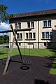
Primary school building
Old car wash

Church window


Web links
- Information about Damphreux (French)
- Dominique Prongué: Damphreux. In: Historical Lexicon of Switzerland .
Individual evidence
- ↑ Permanent and non-permanent resident population by year, canton, district, municipality, population type and gender (permanent resident population). In: bfs. admin.ch . Federal Statistical Office (FSO), August 31, 2019, accessed on December 22, 2019 .
All | La Baroche | Basse-Allaine | Beurnevésin | Boncourt | Bonfol | Bure | Clos du Doubs | Coeuve | Cornol | Courchavon | Courgenay | Courtedoux | Damphreux | Fahy | Fontenais | Grandfontaine | Haute-Ajoie | Lugnez | Porrentruy | Vendlincourt
Former parishes: Asuel | Bressaucourt | Buix | Charmoille | Chevenez | Courtemaîche | Damvant | Fregiécourt | Miécourt | Montenol | Montignez | Montmelon | Montvoie | Ocourt | Pleujouse | Réclère | Roche-d'Or | Rocourt | Seleute | Saint-Ursanne
Canton of Jura | Districts of the Canton of Jura | Municipalities of the Canton of Jura