
Fontenais
| Fontenais | |
|---|---|
 |
|
| State : |
|
| Canton : |
|
| District : | Porrentruy |
| BFS no. : | 6790 |
| Postal code : | 2902 Fontenais 2904 Bressaucourt |
| Coordinates : | 572973 / 250 434 |
| Height : | 458 m above sea level M. |
| Height range : | 435–911 m above sea level M. |
| Area : | 19.99 km² |
| Residents: | 1685 (December 31, 2018) |
| Population density : | 84 inhabitants per km² |
| Website: | www.fontenais.ch |
| Location of the municipality | |
  |
|
Fontenais is a municipality in the Porrentruy district in the canton of Jura in Switzerland .
geography

Fontenais is 458 m above sea level. M. , 1.5 km south of the district capital Porrentruy (air line). The village extends in a side valley of the Allaine at the northern foot of the Kettenjura in the Ajoie (German Elsgau ).
The area of the 10.5 km² municipal area includes the valley basin of Fontenais, which is bounded in the north by the hills La Banné ( 511 m above sea level ) and La Perche ( 526 m above sea level ). Between these hills there is a gorge-like narrow point through which the Fontenais valley is drained to the Allaine. To the south, the municipality extends to the Jura ridge of Lomont with the Col de Montvoie and achieved Les Chainions with 909 m above sea level. M. the highest point of the municipality. The northern slope of this chain is densely forested and subdivided by several erosion valleys, but most of them have no surface running water. The Combe de Secroux dry valley forms the eastern border . In 1997, 7% of the municipal area was accounted for by settlements, 44% by forests and woodlands and 49% by agriculture.
The village of Villars (formerly Villars-sur-Fontenais ), 553 m above sea level, belongs to Fontenais . M. is on a ledge on the northern slope of the Lomont chain, as well as several individual farms. The neighboring communities of Fontenais are Porrentruy , Cornol , Courgenay and Clos du Doubs in the canton of Jura and Montancy in neighboring France.
population
| Population development | |
|---|---|
| year | Residents |
| 1850 | 680 |
| 1900 | 1,248 |
| 1910 | 1,148 |
| 1930 | 983 |
| 1950 | 1.012 |
| 1960 | 991 |
| 1970 | 1,024 |
| 1980 | 1,093 |
| 1990 | 1,125 |
| 2000 | 1,249 |
With 1685 inhabitants (as of December 31, 2018) Fontenais is one of the larger municipalities in the canton of Jura. 95.0% of the residents are French-speaking, 2.8% German-speaking and 1.0% Italian-speaking (as of 2000). The population of Fontenais saw a significant increase in the second half of the 19th century. After a decline at the beginning of the 20th century, a slow but continuous increase in population has been registered since 1960.
economy
Fontenais was a predominantly agricultural village until the end of the 19th century , after which the watch industry quickly gained in importance. In the last few decades, Fontenais has transformed into a residential community whose workers are mainly employed in Porrentruy. Thanks to the fertile soils in the area, agriculture is still very important today.
traffic
The community is very well developed in terms of transport. It is located near Porrentruy and can also be easily reached via the A16 motorway , which is to be connected to both the Swiss national road network and the French motorway network by 2015. A municipal road leads from Porrentruy via Fontenais over the Lomont chain to Glère in the French Doubstal . Fontenais and Villars are connected to public transport by a postbus course to Porrentruy.
history
Fontenais was first mentioned in 1148 as Fonteneis . The place name, derived from the late Latin word fontana ( fountain ), can be traced back to the source in the village. Fontenais shared the checkered history of the Ajoie, which came to the Duchy of Basel in 1271 . It was under the Meieramt Alle from the 16th to the 18th century . During the Thirty Years War it was occupied by French and Swedish troops. From 1793 to 1815 Fontenais belonged to France and was initially part of the Département du Mont-Terrible , from 1800 connected with the Département Haut-Rhin . By decision of the Congress of Vienna , the place came to the canton of Bern in 1815 and on January 1, 1979 to the newly founded canton of Jura.
Since January 1, 2013, the former municipality of Bressaucourt has also belonged to Fontenais.
Attractions
The parish church of Saint-Pierre-et-Paul was built in 1935. The castle, which was built in 1740 in Rococo style for the prince-bishop doctor Jean Faber, has two massive towers with onion domes. Since 1976 the building has belonged to the municipality, which housed the municipal administration in it. To the southwest of Fontenais is the Sainte-Croix chapel, which dates from 1445 and was an important pilgrimage site for a long time. The first chapel was built in Villars in 1704, the current construction dates back to 1962.
photos

church

Wall mosaic in the choir of the church
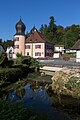
Fountain and castle

Place de la Fontaine


Web links
- Official website of the municipality of Fontenais (French)
- Dominique Prongué: Fontenais. In: Historical Lexicon of Switzerland .
Individual evidence
- ↑ Permanent and non-permanent resident population by year, canton, district, municipality, population type and gender (permanent resident population). In: bfs. admin.ch . Federal Statistical Office (FSO), August 31, 2019, accessed on December 22, 2019 .
All | La Baroche | Basse-Allaine | Beurnevésin | Boncourt | Bonfol | Bure | Clos du Doubs | Coeuve | Cornol | Courchavon | Courgenay | Courtedoux | Damphreux | Fahy | Fontenais | Grandfontaine | Haute-Ajoie | Lugnez | Porrentruy | Vendlincourt
Former parishes: Asuel | Bressaucourt | Buix | Charmoille | Chevenez | Courtemaîche | Damvant | Fregiécourt | Miécourt | Montenol | Montignez | Montmelon | Montvoie | Ocourt | Pleujouse | Réclère | Roche-d'Or | Rocourt | Seleute | Saint-Ursanne
Canton of Jura | Districts of the Canton of Jura | Municipalities of the Canton of Jura