
Beurnevésin
| Beurnevésin | |
|---|---|
 |
|
| State : |
|
| Canton : |
|
| District : | Porrentruy |
| BFS no. : | 6773 |
| Postal code : | 2935 |
| Coordinates : | 577.31 thousand / 260454 |
| Height : | 422 m above sea level M. |
| Height range : | 414-534 m above sea level M. |
| Area : | 5.09 km² |
| Residents: | 123 (December 31, 2018) |
| Population density : | 24 inhabitants per km² |
| Website: | www.beurnevesin.ch |
 Beurnevésin |
|
| Location of the municipality | |
  |
|
Beurnevésin is a municipality in the Porrentruy district in the canton of Jura in Switzerland . The former German name Brischwiler is no longer used today.
geography
Beurnevésin is 422 m above sea level. M. , 10 km north-northeast of the district capital Porrentruy (air line). The farming village extends in the valley of the brook Vendline in the north of the Ajoie (German Elsgau ).
The area of the 5.1 km² municipal area includes the undulating table Jura landscape of the Ajoie, which is traversed by the Vendline valley. In the north, the area extends to the wooded heights of Les Toyers ( 512 m above sea level ) and Le Mont , at 530 m above sea level. M. the highest elevation in the community. The border between Switzerland and France also runs above these heights . The area is drained from the Vendline to the Allaine . In 1997, 5% of the municipal area was in settlements, 38% in forests and woodlands, 56% in agriculture and around 0.5% was unproductive land.
Several individual farms belong to Beurnevésin. Neighboring municipalities to Beurnevésin are Lugnez , Damphreux and Bonfol in the canton of Jura and Pfetterhouse and Réchésy in France.
population
With 123 inhabitants (as of December 31, 2018), Beurnevésin is one of the smaller communities in the canton of Jura. 83.4% of the residents are French-speaking, 15.9% German-speaking and 0.6% Italian-speaking (as of 2000). The population of Beurnevésin was 347 in 1850, compared to 248 in 1900. There was an overall downward trend over the course of the 20th century.
economy
Beurnevésin is still predominantly agricultural . There are few jobs outside of the agricultural sector in the village. Many workers (more than 50%) are therefore commuters and work mainly in the Porrentruy region.
traffic
The municipality is located off the major thoroughfares in the border region of the northeastern Ajoie, but has one border crossing to the neighboring French municipalities. The village is connected to public transport by a bus line that runs from Porrentruy via Coeuve and Lugnez to Beurnevésin.
history

Beurnevésin is first mentioned in 1270 as Brunnevisin , which is interpreted as being near a well . The village shared the eventful history of the Ajoie, which first came to the Duchy of Basel in 1271 . It was under the Meieramt Coeuve from the 16th to the 18th century . From 1793 to 1815, Beurnevésin belonged to France and was initially part of the Département du Mont-Terrible , from 1800 connected to the Département Haut-Rhin . By decision of the Congress of Vienna , the place came to the canton of Bern in 1815 and on January 1, 1979 to the newly founded canton of Jura.
Attractions
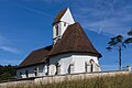
Above the village stands the Saint-Jacques church, which until 1802 belonged to the parish of Damphreux . The church has a late Gothic choir with wall paintings that were created around 1500. The current nave dates from 1829.
In the forest of Les Côtes north of the municipality is the boundary stone Borne des Trois Puissances , which marks the point that marked the triangle between Switzerland, France and Germany (to which Alsace belonged during this time) in 1871–1920 and 1940–1944 .
photos

Saint-Jacques church

Beurnevésin

At the roundabout
Saint Jacques Church

Church window (Hans Stocker)


Web links
- Information about Beurnevésin
- Bernard Prongué: Beurnevésin. In: Historical Lexicon of Switzerland .
Individual evidence
- ↑ Permanent and non-permanent resident population by year, canton, district, municipality, population type and gender (permanent resident population). In: bfs. admin.ch . Federal Statistical Office (FSO), August 31, 2019, accessed on December 22, 2019 .
All | La Baroche | Basse-Allaine | Beurnevésin | Boncourt | Bonfol | Bure | Clos du Doubs | Coeuve | Cornol | Courchavon | Courgenay | Courtedoux | Damphreux | Fahy | Fontenais | Grandfontaine | Haute-Ajoie | Lugnez | Porrentruy | Vendlincourt
Former parishes: Asuel | Bressaucourt | Buix | Charmoille | Chevenez | Courtemaîche | Damvant | Fregiécourt | Miécourt | Montenol | Montignez | Montmelon | Montvoie | Ocourt | Pleujouse | Réclère | Roche-d'Or | Rocourt | Seleute | Saint-Ursanne
Canton of Jura | Districts of the Canton of Jura | Municipalities of the Canton of Jura