
Three-country corner of Europe
Of the 178 “ tripoints ” recorded by the United Nations worldwide, there are 48 points in Europe where three countries border one another . Not internationally recognized European countries such as Transnistria and Kosovo are listed here .
Current triangle

.jpg)


.jpg)
.jpg)
.jpg)


Overview map
|
Missing triangles on the map of Europe can be found in the Balkans section:
|

_location_map.svg)
Remarks
- ↑ Land triangle since the establishment of the Prussian-Dutch condominium in 1815, politically revised by the independence of Belgium from the Netherlands in 1830, Luxembourg from Belgium in 1839 and the establishment of the German Empire in 1871. The exact course of the border lines through the main arm of the Moselle , the extension of the FD crossing of the northern part of the lock island and the further course, was determined by the agreement between Germany and Luxembourg on December 19, 1984 (see Community German-Luxembourg territory ).
- ^ Boundary by the valley path of the Rhine since the First Peace of Paris in 1814 . In 1818 boundary stones were erected, which also declared the line to Switzerland on the north bank of the Rhine port of Kleinhüningen. The striking monument stands 150 m southeast on Swiss soil. The three-country bridge ( French Passerelle de trois Pays ) crosses the Rhine 200 m north and connects Germany ( Weil am Rhein ) with France ( Huningue ). About 36 km west-southwest near Beurnevésin you can still find the former tri-border area " Borne des Trois Puissances ".
-
↑ Unfixed triangle since the Bavarian assignment of Vorarlberg in Austria in the signed on June 3, 1814 Paris Convention . With the establishment of the German Empire in 1871, the current political format was established, which focused on a hypothetical equidistant point in Lake Constance. The lake is administered as a condominium , see also territorial affiliation of Lake Constance .
There is also an agreed between the neighboring states administrative boundary which triangle at about 47 ° 31 ' N , 9 ° 34' O is located. - ↑ Trojmezí : an important point of the Bohemian Forest is the Trojmez, the former border of Bohemia , Austria and Bavaria since 1765, which was revived by the dismemberment of Austria-Hungary in 1919. After the dissolution of Czechoslovakia, the point was remonumented in 1993. The original triangular landmark from 1765 has been replaced by new boundary stones. See: Šumava. In: stara-sumava.cz. Retrieved April 13, 2020 (Interesting historical photos and images). Šumava. In: stara-sumava.cz. Retrieved April 13, 2020 (images from 1930). . Not to be confused with the triangle at Trojmezí , see → Historical triangle (D-DDR-ČSSR)
- ↑ The current political constellation has existed since the breakup of Czechoslovakia in 1993. The triangle formed at the confluence of the Ullersbach in the Lusatian Neisse as a result of the separation of the German eastern areas by the Potsdam Conference in 1945 and the definition of the Polish western border on the Oder-Neisse line . The border triangle Germany-Poland-Czech Republic was previously 280 km southeast of the 1919 position near Bohumín ( German Oderberg ). There are plans to connect the three countries with bridges over the water, see Die Brücke and An Seilen over the Neisse , Sächsische Zeitung of February 15, 2018.
- ↑ With the independence of Luxembourg from Belgium in 1839 through the partition of Belgium, the border point to the German Empire was created. The border line along the western bank of the Our and the Ribbach, which flows in at right angles, form the meeting point. The entire width of the Our river bed forms the Lëtzebuerg-Deutschland condominium ( joint German-Luxembourg sovereign territory ) from the triangle (Georges Wagner Bridge ). On the bank you can find the German-Belgian border stone № 1 from 1922 and a - probably older - stone № 52 on the corner of Luxembourg.
- ↑ When the Austrian Netherlands (formerly Burgundian , then Spanish Netherlands ) became independent from the Netherlands in 1830 and became the Kingdom of Belgium , a three-country point was created between independent states.Formerly also the condominium border point of the Dutch-Prussian territory Neutral-Moresnet from 1816 to 1919 and thus the four-country corner. The current political format dates from 1920, marked by an octagonal obelisk as a monument with the number 193, which is attributed to the original demarcation from 1818 and is a replacement for the official boundary stone from 1926 . 150px | left | Formerly the highest point in the Netherlands Until October 10, 2010 it was also the highest mountain in the Netherlands. The 322.4 m NAP high Vaalserberg lost this status when, with the dissolution of the Netherlands Antilles, the Caribbean island of Saba with the 877 m high volcano Mount Scenery was incorporated into the national territory of the Netherlands as a “ special municipality ”.
- ↑ The border point is in the middle of the water. Already in the 14th century it was the border between Austria, Moravia and Hungary. When Czechoslovakia broke up in 1991, the course according to the agreement of 1928 started again.
- ↑ Since the independence of Slovakia in 1993, successor to the tri-border region Austria - ČSSR - Hungary, which existed since 1947. In 1921, when “German West Hungary” was brought to Austria as Burgenland, a border point was created. Then the border between Czechoslovakia and Hungary was moved seven kilometers. As a result of the expansion of the Bratislava bridgehead , an additional small area fell from Hungary to Czechoslovakia on October 16, 1947.
-
↑ Successor to the triangle Austria-Hungary-Yugoslavia created by the independence of Slovenia in 1991, which was created in 1921 by the cession of Burgenland from Hungary to Austria through treaties of Saint Germain & Trianon. The dates are recorded on the memorial.
- Bojan Flander: Tromejnik - KRAJI - Slovenia. In: KRAJI. Retrieved on April 13, 2020 (private photo website, with panorama and detailed views).
- ↑ In 1955, the historical boundary line at markers 135 & 136 was precisely defined in the central channel of the straightened Alpine Rhine. Border point since the collapse of the German Confederation in 1866
- ↑ Dreiländereck since 1866. The summit cross (2571 m) marks the three-country point. The ascent of the height is a bit tedious.
-
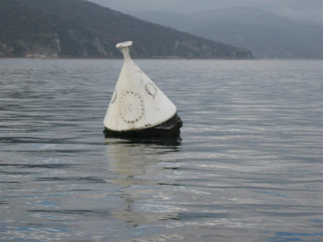
↑ It is the southernmost triangle in Europe.
An ordinary buoy in the lake marks the boundary point. - ↑ South of Prizren ; 4.7 km south of the Kallabak (2174 m). In June 2008 an approx. 2 m large, white boundary stone was inaugurated.
-
↑ on September 3, 1945 the autonomous region "Kosovo and Metohija" in Yugoslavia was integrated as part of Serbia. After the unification of Serbia and Montenegro in 2006, there was a binational administrative three-point. With the establishment of the Republic of Kosovo, a three-country triangle was created on the summit of Tromeda. The point is marked by a cairn .
- Road trip Albania and Montenegro , April 5, 2017, German with illustration
- Trekufiri / Tromedja summit book with interesting pictures
- Ascensión a el Pic de Medacorba (2914 m) por PEPINTO, July 18, 2004.
- ↑ Not officially declared as a triangle until 1993, but described as such since 1862. At the summit a cairn with an iron post as an informal marker.
-
↑ Portella Blanca has been a used pass crossing since 1278, later marked by the Spanish-French border stone № 427. Officially declared a triangle in 1993.
It is the westernmost triangle of Europe. -
↑ The area around the border triangle is easily accessible from Luxembourg via a junction of the N5F , but the exact point of the border triangle is difficult because this is in a steep and densely overgrown depression of the stream. The border point is marked by a slender, white cone overgrown by bushes. In addition, there have been cast iron markings № 1 between Belgium and Luxembourg since 1843.
- ' Grenspaal 001-010 ', illustrated description in Flemish
- ↑ 2 km north-north-west of Dubravka and 700 m west-south-west of the "Granični prijelaz Sitnica" border crossing between Serbia and Bosnia-Herzegovina. Not yet clearly defined (see Treaty on the State Border between the Republic of Croatia and Bosnia and Herzegovina , UN , July 30, 1999), marked by a barely recognizable stone pyramid.
- ^ The confluence of the Sava valley path (border with Bosnia-Herzegovina) north of the mouth of the Lukavac brook from the south as an extension (Serbia / Croatia border); between the places Bijeljina- Novo Naselje (BIH), Račinovci (HR) and Jamena (SRB). Since the independence of Bosnia-Herzegovina in 1992, agreed in 1999 and set in 2006 at the point that had existed since 1945 as a result of the meeting of the administrative borders of the three Yugoslav republics. Border marks are not recognizable.
- ↑ The triangle since the separation of Serbia and Montenegro in 2006. At the former meeting point of the Yugoslav republics, which has been shown on maps since 1945 or earlier. There is currently no binding intergovernmental regulation. The point is not conspicuously marked.
- ↑ A land point that was created for the independence of Macedonia in 1991 on the basis of a definition of 1913 by the Treaty of Bucharest , in which the Ottoman Vilayet Saloniki was distributed among its three occupiers. The exact location of the original country triangle was undoubtedly elsewhere, but in 1919 the Treaty of Neuilly-sur-Seine in favor of Bulgaria moved it from its actual location on the Belasiza ridge to the Tumba summit. It was demarcated from Bulgaria on one side as early as 1813 and was fixed prematurely by the boundary stone number 1. The summit is marked by a three-country stone that needs to be restored.
-
↑ The border point offered to tourists is directly south of the border crossing. A whitewashed concrete tetrahedron crowned with the three national flags marks the place somewhat modestly. Access is only allowed one way. On the small island 700 m southwest in the Mariza and southeast of the border point there is another, more representative monument next to the Greek-Bulgarian boundary stone № 1 and the Turkish-Bulgarian boundary stone № 320B. It is not freely accessible.
- photo
- Fronteras que pasan por donde quieren. Abundant illustration on whimsical borders
- Dilofos: The village of the miners during the triumph of Evros Photo of the landmark Bulgaria, Greece, Turkey
-
↑ Item since the independence of Macedonia in 1991 following the Yugoslav border crossing to Bulgaria from 1945 or since 1919. The international border was established or reinforced in 2001 according to the agreement of 1922, in 1922 the Yugoslav-Bulgarian boundary stone No. 106 was erected here and in November 2002 it was replaced by a three-part marker stone. Occasionally it is stated that it is also the westernmost point of Bulgaria, which is wrong - this point is near Makresch , i.e. 330 m further west!
- Picture gallery
- Inauguration of the Dreiländerstein (see 4th and 5th articles, English)
- ↑ Three-country triangle since the 14th century with interruptions within the Ottoman Empire , which connected other borders after Romania's independence in 1878. First as Romania - Serbia - Turkey until Bulgaria's independence in 1908 and then Bulgaria - Romania - Yugoslavia until 2003. This treaty established the valley route of the Danube as the border with Romania to the mouth of the Timok, which separates Bulgaria and Yugoslavia - since 2003 Serbia.
-
↑ The historic three-country corner, which has been restored since Estonia gained independence in 1991, inherited the three-country corner of the Soviet republics , which emerged in 1945 from the original three-country corner of Estonia, Latvia and Russia. This was created for the first time in 1920 with the independence of Latvia and until the Second World War it lay on the center line of the Pededze River about 90 m above the Laikupe estuary. Until the middle of the 20th century, the border lay on the west bank, which is marked by the Estonian-Latvian boundary stone № 46plus1379. The Latvia-Russia border meets it with a bearing of 40 °.
- Eesti ja Läti piir document on demarcation
- Country triangle map
- Robežsardzes izveidošana 1919-1940 , Border Guard Establishment ( Latvian )
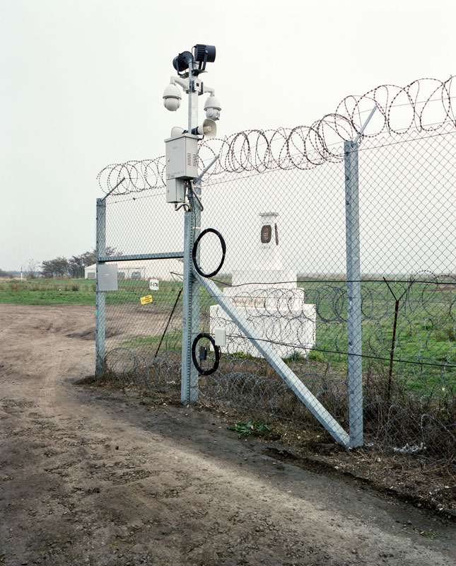
- ↑ a b c d e Entering Russian soil threatens sensitive measures on the part of the Russian border troops . Even simply going around the three-country point and thus crossing the border to Russia can be punished as an illegal border violation.
-
^ Border between Finland - Norway - USSR since the armistice of Moscow on September 19, 1944, after the Pechenga district was ceded by Finland to the Soviet Union. The configuration was changed by various trilateral protocols from 1947 to 1953. For the first time in 1846 this point was marked with a pile of stones as boundary stone number 94. The current demarcation on the Korgfjellet or Muotkavaara (145 m) got its current political significance in 1991 with the fall of the Soviet Union. Currently there is a white tetrahedron on the cairn , which is labeled with the names of the neighboring countries. The pile of stones is surrounded by various prohibition signs.
- Interesting video from 2003. The situation is now less inviting.
- The trifinium Norway - Finland - Russia , well illustrated, English
-
↑ The three-country point, the northernmost three-country corner in Europe and worldwide, was historically very changeable and at times interrupted. The story begins in the 18th century between Denmark, Russia and Sweden on the swampy, changeable south- eastern shore of Lake Goldajärvi. After the conquest by the Swedes, the independence of Norway and the independence of Finland, the constellation changed several times. Currently you can see an artificial small peninsula near the shore with a concrete block in the form of a yellow painted truncated cone that can be surrounded on a jetty . At the top there is a stone that indicates the residents by name and coat of arms.
- Jan S. Krogh's Geosite : Finland - Norway - Sweden (FINOSE), description (English) and illustration
- ↑ Today's tri-border area was established in 1815 at the Congress of Vienna . The fixed point is not the top of Mont Dolent (3750 m), but a point about 70 m below and 160 m northwest of the summit. There are no known reports of tourist visits, especially since there is a general misunderstanding that the summit is assumed as a border connection.
-
↑ The three-country point was relocated in 1919 about 36 km north of the original position from the 16th century, the three-language peak near Stilfs . When the fascists came to power in Italy in 1922, South Tyrol was effectively taken over from Austria by Italy. Now the point is on the north shoulder of Piz Lad.

-
↑ Successor after Slovenia's independence in 1991 to the original Austria-Italy-Yugoslavia border triangle, which was established in 1919 by the Treaty of St. Germain on the summit of Peč / Ofen / Monte Forno at the transition from the Carnic to the Julian Alps , the Canal Valley , was established. 3.69 m east of the existing triangulation point, a square stone pillar was erected in 1924 with the inscriptions “1, Ö, XXVII, 294, P-519 over RI” on the side and the indicated angle of the borders on the top.
- Hike to the border triangle Slovenia - Austria - Italy Die Weltbummler 2014
- ↑ An inconspicuous triangle between eastern Kosovo with the trunk of Serbia and the adjacent North Macedonia on an unnamed summit of the Glinja ridge with a height of 1056 m
-
↑ The course of the border in this area is very controversial, as the neighbors have different territorial claims. However, the terrain is swampy, inaccessible and hardly useful. Therefore, open conflicts are not worthwhile.
The demarcations established in 1919 were adopted by the Yugoslav republics, are currently located in the valley path of the Danube between Croatia and Serbia and have been marked since 1920 with the Hungarian-Yugoslav boundary stones № 415 and № 420. However, Croatia claims a border along the Ferenc Canal , which would move the three-country point about 6 km east to the boundary stone № 465. -
↑ The course of the border has been controversial since Slovenia gained independence in 1991. Originally, the borders of 1929 that were taken over by Yugoslavia were between the federated republics. Slovenia sees the valley path of the Mur (river) as a border, the Croatians claim to draw a border north of it, for example along the Kerka / Ledava. Allegedly there were some illegal land transfers around 1956 that are now leading to border disputes.
- see MURA , p. 37
- Card 1 - Card 2
- The Depiction of International Boundaries on Topographic Maps , Gerald Blake, p. 4
-
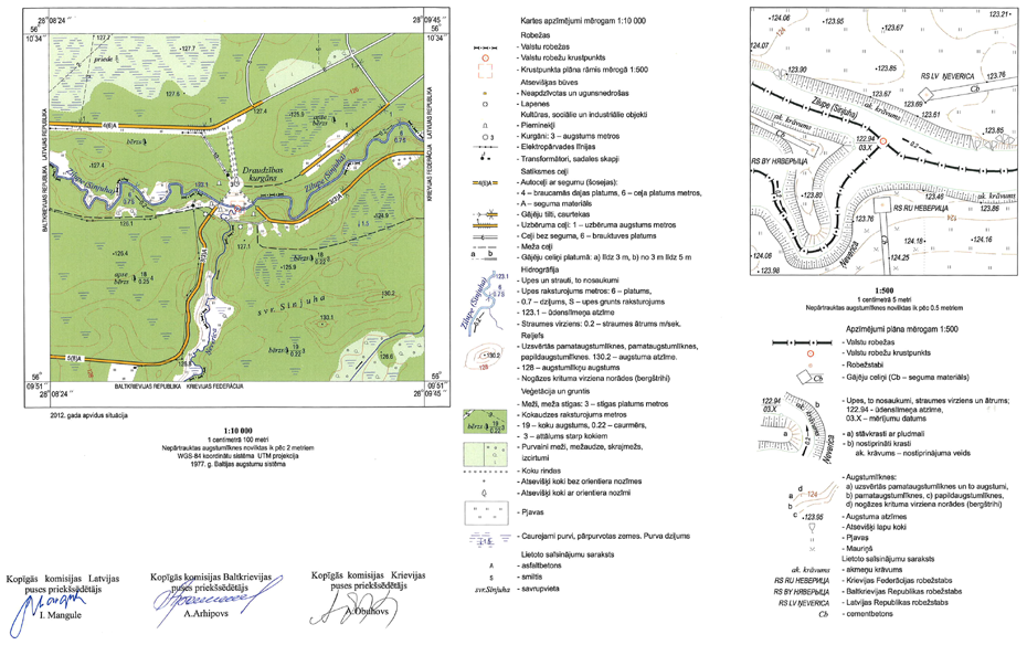
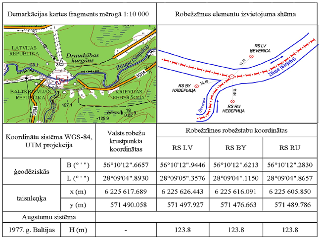
↑ a b The exact three-country point lies in the middle of the confluence of the Neveritsa in the Zilupe. A conspicuously marked point ("Hill of Friendship") was built in Soviet times 99 m north on what is now Latvian territory. From 1959 to 1990 this hill was the tri-border area of the Latvian SSR , Belarusian SSR and the Russian SFSR . Three memorial stones in Latvian, Belarusian and Russian still commemorate the heroic partisans of these three republics who sacrificed themselves for the Soviet motherland (analogous translation) . In the past, song and music festivals were often held there.
Around the measured three-country point there are border steles on the banks of Latvia, Belarus and Russia. A pedestrian bridge spans the Zilupe between Latvia and Russia. The bridge is marked on both sides with two border posts and may only be used by officially authorized persons (border officials) or under supervision. The bridge from Latvia to Russia is also blocked by barriers.
On the border with Latvia, Russia and Belarus, celebrations are held every year to commemorate the glorious Soviet heroes of World War II (analogous translation) . A typical Russian spectacle that is hosted by the Latvians. Participants from neighboring countries must enter via Burachki / Terehova (31 km, Russia) or via Grigorovshchina / Paternieki (78 km, Belarus).- Byelorussia (BY) - Latvia (LV) - Russia (RU) trifinium
- Latvia - Russia - Belarus
Map triangle 1 - Map triangle 2
-
Latvijas Republikas, Baltkrievijas Republikas un Krievijas Federācijas valsts robežu krustpunkta State Treaty in Latvian
Video Friendship Hill , May 18, 2018 by Ivar Zviedris. - Photo gallery
-
↑ Only accessible from Lithuania.
From the border crossing at Grivočka (LV, also the southernmost point of Latvia) drive southeast on the road № 5318 in the direction of Skirna (LT). After approx. 950 m behind a wide right-hand bend, a simple gravel path goes off to the left (east). The junction is not signposted (as of 2018). After 800 m in the forest, keep half left and follow the mostly unpaved path for another 2.2 km until the triangle of three countries is visible in a clearing. Because of the bad road, a hike is preferable. The tri-border area was made attractive a few years ago, but there is no tourist infrastructure.
The way from Latvia is arduous, especially since the border area is only passable for locals or with special permission. Access from Belarus is only possible for rare, controlled events. -
↑ The three-country triangle that has historically changed several times and was re-established in 1990 with the independence of Lithuania. Until 1991 the border point Poland-USSR was visible or as the triangle VR Poland - Russian SFSR - Lithuanian SSR . The point was created by the Potsdam Conference in 1945 at a former version location that was established in 1919 by the Treaty of Versailles . It was changed by the division of East Prussia between Poland and Russia and marked for the first time in 1946. In 1987 this point was politically fixed again and made representative in 2010.
If various internal territories or administrative units are taken into account, the result is a quadrilateral triangle, since the Polish Voivodeships of Podlasie and Warmia-Masuria meet with the Kaliningrad Oblast (exclave of Russia) and Lithuania.- Ruszył remont znaków granicznych na trójstyku , May 11, 2010, GOLDAP.INFO, Polish, well illustrated
-
↑ The former border triangle of the German Empire, Lithuania and the USSR from 1939 to 1940 was revived in 1990 when Lithuania gained independence. Since Belarus became independent at the end of 1991, the middle line of the Marycha River (in Lithuanian Seina , Belarusian Марыха ) has been the border. The only Lithuanian border stone from 1947 was recently removed, while in 2011 a comprehensive trilateral agreement was concluded and the triangle was made a little more attractive. There are currently three boundary posts around an imaginary boundary point in the watercourse. On the east side of Marycha is the Lithuanian gene stake. On the southwest side are the markings of Poland and Belarus. The border between the two states is marked by a wide swath. The Belarusian border fortifications are hidden in the forest. There are no significant border fortifications between Poland and Lithuania.
Jan S. Krogh's Geosite : Byelorussia (BY) - Lithuania (LT) - Poland (PL)- Jak zdobyliśmy trójstyk POLSKO-LITEWSKO-BIAŁORUSKI , Polish forum post at Camper Team, well illustrated
- ↑ Since the collapse of the USSR in 1991, the country triangle established by the founding of the Moldavian SSR in 1945 in a territory ceded by Romania to the Soviet Union. This was determined in 1991 by Soviet mapping on the Prut in accordance with the 1940 treaty. A demarcation between Moldova and Ukraine has been visible since 2004 with the boundary stones № 0001 and № 0002. The tri-border point is located 600 m southeast of the Mamalyha border crossing
- ↑ Since the collapse of the USSR in 1991, the country triangle established by the founding of the Moldavian SSR in 1945 in a territory ceded by Romania to the Soviet Union. This was determined in 1991 by Soviet mapping at the mouth of the Prut into the Danube (in the middle of each river) in accordance with the 1940 treaty between Romania and the USSR. The boundary stones № 1335 and № 1336 from 1949 were replaced in 2004 by Ukrainian-Romanian markings.
-
↑ Since the dissolution of Czechoslovakia in 1993 as a result of the binational triangle that was created in 1920 when the Duchy of Teschen was divided between Poland and Czechoslovakia. In 2007 the point was marked by a small obelisk in the mostly dry stream bed. All three residents have set up a number of interesting markings on the area around 50 m around the point. It is a tourist attraction.
Until 1918, the historical border between Silesia and Galicia ran over the ridge of the Silesian Beskids along today's border between the districts of Teschen ( Cieszyń ) and Saybusch ( Żywiec ). The historic triangle between Silesia ( Duchy of Teschen ), the Kingdom of Galicia and the Kingdom of Hungary (Slovakia) was about 10 km further east on Trojaki Mountain (646 m) northwest of Zwardoń. -
↑ At the ridge crossing of the Kremenez summit since the cession of Ruthenia from Czechoslovakia to the Soviet Union in 1945. After Slovakia separated from the Czech Republic in 1993, the tri-border point Poland - Slovakia - Ruthenia from 1919 was re-established. In fact, Galicia met here with the Hungarian counties of Semplin and Ung since the 11th century. It is marked by a monument from the late 20th century. Several steles and the border posts of the neighboring countries mark the triangle. Access is difficult. Therefore it is not interesting for tourists.
- Hiking the Kremenec , 2005, English report with illustration
- ↑ Dreiländereck since the collapse of the Soviet Union in 1991 as a result of a binational transition that came about in 1939 when Germany and the Soviet Union agreed to the Curzon Line originally proposed in 1919 , which was restored by Poland and the Soviet Union in 1946. An agreement from 1998 defined the triple intersection of the center line of the western bow and the extension of the southern bank of Kanał Mościckiego and the line of sight between the Polish-Soviet bank markers № 1123. There are now some markings and restrained tourism.
-
↑ Dreiländereck, which was established in the Treaty of Trianon in 1920 at an originally undefined location. It was fixed by the multinational commission at the beginning of 1921 and then apparently moved about 10 km to the southwest in 1923 according to the Romanian-Yugoslav protocol. Today it is marked by a so-called “Triplex Confinium Monument”, which is still considered No. 1 of the Hungarian-Romanian and Romanian-Yugoslav numbering of the boundary stones.
With the erection of the Hungarian border fence , the attractiveness of the place is massively disturbed.- The end of the fence at the end of the world , ARD Vienna, August 28, 2015
- Photo by Patrick Galbats: Dreiländereck - Hungarian border security , see also The photographer Patrick Galbats: Art and witness
- ^ Condition before the construction of the Hungarian border fence .
-
↑ The triangle originally linked Czechoslovakia - Hungary - Romania according to the Trianon Peace Treaty of 1920, which, however, provided for the border point about 10 km north of the present position. In 1921 international commissioners erected the boundary stone near the current location, before it was transferred from Czechoslovakia to the Soviet Union when Carpathian Russia was surrendered in 1945 and became the triangle of the USSR - Hungary - Romania. With the independence of Ukraine in 1991, the point was fixed at the central intersection of the main canalized canal and the natural side canal of the River Túr. The boundary markings remained unchanged. Access from Garbolc is possible on a 3.5 km bad road.
There are a few boundary stones and a monument on land in the immediate vicinity: boundary stone 1 , boundary stone 2 , boundary stone 3 - ↑ Easternmost point of Hungary at the triangle
-
↑ The easternmost triangle of Europe is located in the roundabout (triangular!) With three border crossings on the access roads. In the middle is a tall monument. The residents of neighboring areas call it "Joint" ( Russian Стык ) .
During the Soviet era, the monumental monument of the "Three Sisters" ( Russian: "Три сестры" ) was built for the friendship of the three East Slavic peoples. Some believe that the point is located within a radius of about three miles in a neutral zone that does not belong to any state. However, this is not the case: there are no neutral zones between the areas of the three residents . The state borders of Russia and Ukraine are determined by the 2004 border treaty between the two countries. The state border between Ukraine and Belarus is not precisely defined, as the National Assembly of Belarus has not yet ratified the international treaty, in contrast to the Verkhovna Rada of Ukraine, which did so in 1997.- Terminus Belarus , Deutsche Welle
- Image of the border triangle in the roundabout
- Международный фестиваль славянских народов "Славянское единство" у монумента Дружбы "Drei" ("Три сестры") International Festival of the "Slawischen Peoples" ( German ) ( German ) Festival of the "Slaws" . Report (Russian), well illustrated
- ^ The triangle since the cession of Carpathian Russia and small parts of Slovakia in 1945 by Czechoslovakia to the Soviet Union. A somewhat indeterminate location, apparently without priority, at the intersection of a former branch and the current course of the Tisza was specified in Article 30 of the 1920 Treaty of Trianon . There is a marking by the Slovak-Ukrainian boundary stone pair № 375 from 1946 and the Czechoslovak demarcation to the USSR, also from Hungary-Ukraine and Hungary-Slovakia markings of unknown series.
Historic triangle of three countries
Historically, a triangle is when, due to political changes, three states no longer meet at the same point. In most cases, a state now collides with the internal administrative borders of the other state (federal states, cantons, associations, departments, etc.). In many cases the border point is still marked and recognizable. Some of the historic three-country corners are still of touristic importance. In addition, there are many three-country corners that have existed for so long that they are historical, but are listed here with the current ones.
The numerous borders of earlier politically and administratively independent kingdoms, principalities and city-states that are now part of today's states are not recorded.
As a reminder: Up until the founding of the German Empire in 1871, there were partially sovereign states, each with their own citizenship, their own national borders and, consequently, a large number of three-country corners:
|
Grand Duchy of Mecklenburg-Schwerin Grand Duchy of Mecklenburg-Strelitz Principality of Reuss older line |
Grand Duchy of Saxony-Weimar-Eisenach Principality of Schaumburg-Lippe Principality of Schwarzburg-Rudolstadt |
In addition, many of these small states have no contiguous national territory, which increases the number of triangles. In other European countries, too, there used to be many sub-states.
| Tri-border region | position | place | from ... to | Remarks | image |
|---|---|---|---|---|---|
|
|
50 ° 10 '57.9 " N , 6 ° 1' 29.3" E | "An der Schmiede" ( Schmëtt in Luxembourg ) , district of Huldingen | 1839-1920 | The three-country corner from the division of Luxembourg to the connection of Eupen-Malmedy to Belgium.
Commons : Dreiländereck Schmätt - Collection of images
|

|
|
|
50 ° 19 '5.6 " N , 12 ° 6' 3.6" E | 3.3 km northwest of Trojmezí | 1949-1990 |
Commons : Dreiländereck BRD-DDR-ČSSR - collection of pictures
|

|
|
|
50 ° 13 '45.7 " N , 19 ° 9' 27.8" E | Dreikaisereck | 1815-1846 | The place was named "Dreikaisereck" because the three neighboring states were ruled by an emperor.
At the confluence of the Black and White Przemsa near Myslowitz in today's Poland
Commons : Triangle of three emperors - collection of images
|
 
|
|
|
1846-1858 | ||||
|
|
1858-1867 | ||||
|
|
1867-1871 | ||||
|
|
1871-1883 | ||||
|
|
1883-1914 | ||||
|
|
1914-1915 | ||||
|
|
1915-1917 | ||||
|
|
1917-1918 | ||||
|
|
49 ° 36 '49.5 " N , 19 ° 28' 2.6" E | " Modralová " (1150 m) | 1939-1945 |
Commons : Koszarawa - collection of images
Commons : Oravská Polhora - collection of images
|
|
|
|
49 ° 31 '0.5 " N , 18 ° 51' 3.6" E | see the triangle of Poland, the Czech Republic and Slovakia | 1939-1945 | ||
|
|
49 ° 29 '48.6 " N , 5 ° 53' 36.3" E | at the "Adlergrund" | 1871-1918 | West of Redingen , south of Oberkorn (L), east of Hussingen-Godhaben (F). |

|
|
|
1919-1920 | ||||
|
|
47 ° 30 '10.7 " N , 7 ° 7' 48.9" E | "Borne des Trois Puissances" near Beurnevésin | 1871-1918 | southeast of the Burgundian Gate
Commons : Borne des Trois Puissances - Collection of images
|
|
|
|
1919-1920 | ||||
|
|
53 ° 54 '43.1 " N , 18 ° 52' 45" E | west of Biała Góra ( German Weißenberg ) | 1920-1939 |
Commons : Biała Góra - collection of images ||
|
|
|
|
55 ° 42 ′ 40 " N , 26 ° 24 ′ 28" E | 1920-1939 | |||
|
|
46 ° 31 '51.2 " N , 10 ° 27' 9.4" E | Trilingual peak | 1866-1867 | on the Stilfserjoch, the triangle of three countries to the annexation of South Tyrol by Italy
Commons : Trilingual peak - collection of images
|

|
|
|
1967-1918 | ||||
|
|
1918-1919 | ||||
|
|
1919-1920 | ||||
|
SHS state German Austria Kingdom of Hungary |
46 ° 50 '7.4 " N , 15 ° 59" 46.5 " E | Sankt Anna am Aigen | 1918-1919 |

|
|
|
|
48 ° 11 '7.4 " N , 26 ° 19" 59.9 " E | Novoselyzja , near Herza ( Ukrainian Герца ) | 1812-1918 | In the valley path of the Pruth between Austrian Nowosielitza and Russian Nowosielitza |
|
|
|
44 ° 41 ′ 46 " N , 22 ° 29 ′ 41.6" E | at the Iron Gate | until 1919 | ||
|
|
48 ° 8 ′ 17.7 " N , 17 ° 7 ′ 2" E | Bratislava bridgehead | 1921-1946 |

|
|
|
|
1946-1947 |
.jpg)
.jpg)


Overview map
|
|


See also
Web links
- Tripoint spotting - a personal diary , Rolf Palmberg
- tricountry 2012 Official United Nations Tripoint Registry Yearbook, 4th Edition
- Dreiländerecke , on dieweltenbummler.de
- Geografia random , “Fronteras que pasan por donde quieren”, various photos of strange borders
- TRIPOINT GURU - a geography quiz , Rolf Palmberg, 2010
- 9 Famous International Tripoints Around The World
Remarks
-
↑ At the end of the village in the Schmiede / Schmätt district on the Route de Stavelot and behind ALDI there is still a high cone (Belgian-Luxembourg border marker LB 286) and on the right-hand side of the road the German-Luxembourg border stone number 75. Also the northernmost point of Luxembourg.
Now the border triangle BLD is 10 km southeast at 50 ° 7 '47.5 " N , 6 ° 8" 15.7 " E - ↑ Until reunification , the triangle was located at the point where Bavaria , Saxony and Bohemia ( Czech Republic ) meet. The triangle is called "Trojmezí" in Czech . The Czech town of Trojmezí , a good 3 km away , was named after it; it used to be called Gottmannsgrün. Now Saxony, Bavaria and Czechs are coming together here.
- ↑ Bismarck Tower at Dreikaisereck , Panorama 360 °
-
↑ a b Due to the Munich Agreement and the subsequent takeover of foreign territories by Germany, Poland and Hungary, there were frequently changing triangles, which, however, mostly remained without sustainable historical significance.
- Sudeten German areas were incorporated into the German Reich (Munich Agreement September 30, incorporation October 1 and 2, 1938)
- Poland occupied the area around Teschen ( Czech Těšín , Polish Cieszyn ) on October 2, 1938 , which was annexed by Czechoslovakia on January 23, 1919, after it came to Poland for the time being after the collapse of the Austria-Hungarians (see also Polish- Czechoslovak border war )
- On November 2, 1938, Hungary occupied border areas, some of which were of Hungarian ethnicity (see Vienna dictation ).
- On March 15, 1939, Hungary occupied the Ruthenian- speaking Carpathian Ukraine (see Viennese dictation).
- On March 15, 1939, the “remaining Czech Republic ” was effectively annexed by the German Reich and declared a protectorate of Bohemia and Moravia .
- From Czechoslovakia only the satellite state Slovakia remains .
- ↑ On the Modralová mountain between Koszarawa in the district of Saybusch ( Polish Powiat Żywiecki ), Oravská Polhora (Slovakia) and Babia Góra National Park ( Polish Babiogórski Park Narodowy ). Developed as a result of arbitrary political acts and the annexation of Poland
- ^ Originated as a result of arbitrary political acts and the annexation of Bohemia and Moravia. Now it is the triangle between the Czech Republic, Poland and Slovakia
- Jump up to the cession of Alsace-Lorraine to France
-
↑ In the forest of Les Côtes (Bois-Défendu)
between the places Pfetterhausen (Alsace), Röschlitz (France) and Brischweiler (Switzerland) is the three- power stone ( Borne des Trois Puissances ), which was built from 1871-1920 (until the cession of Alsace -Lothringen to France) and from 1940 to 1944 formed the triangle of Germany, France and Switzerland. Today the French departments Territoire de Belfort and Haut-Rhin and the Swiss canton of Jura, created on January 1, 1979, meet here. - ^ Originated from the Peace Treaty of Versailles and the Polish Corridor
-
↑ The former border triangle Latvia - Lithuania - Poland lies next to the last Latvian-Lithuanian boundary stone from the pre-war period. The exact position can only be determined from historical maps. On September 17, 1939, the Soviet Union occupied eastern Poland as planned by the German-Soviet border and friendship treaty . In October Lithuania was able to appropriate the formerly Polish Vilnius area. Thus the new triangle also shifted to the south (now LV / LT / BY).
- Jan S. Krogh: Mateikiškė, LT / Grendze, LV. Latvia - Lithuania Boundary Points. Jan S. Krogh's Geosite, December 25, 2012, accessed June 24, 2019 .
- ↑ To this day, there is still a “three-language corner” with Italian ( Lombardy ), German ( South Tyrol ) and Romansh ( Graubünden ). When the fascists came to power in Italy in 1922, South Tyrol was effectively taken over from Austria by Italy. Now the new triangle is on the north shoulder of Piz Lad.
- ↑ "Kraljevstvo Srba, Hrvata i Slovenaca", subsequently the Kingdom of Yugoslavia
- Jump up to the occupation of Bukovina and Bessarabia by Romania
- ↑ west of the Iron Gate , east of the island of Ada Kaleh in the valley path of the Danube , which has been flooded since 1971 .
-
↑ From 1921 to October 15, 1947 (transfer of three Hungarian communities to Czechoslovakia / Bratislava bridgehead ) the triangle was about 7 km north of today's triangle with Slovakia .
This position results from several descriptions, but has not yet been confirmed by any official information or reliable map.- See also " The area of the Bratislava bridgehead around 1873 " (recording sheet of the Franzisco-Josephinische Landesaufnahme . Attention, very large, long loading time )
swell
- ↑ United Nations Tripoint Registry Yearbook 4th Edition , only full members of the UN are recorded
- ^ Kuvendi i Republikës së Kosovës: Ligji No. 04 / L - 087 për Parkun Kombëtar Sharri . December 13, 2012, p. 2 ( kuvendikosoves.org [PDF; accessed March 15, 2019]): "[…] deri të pika kufitare e tri shteteve (Kësula e Priftit), Kosovës me Maqedoninë dhe Shqipërinë."
- ↑ Macedonia - Kosovo demarcation officially starts. In: MINA. June 30, 2008, accessed March 15, 2019 .
- ↑ a b The tripoints of Andorra
-
↑ The western Tripoint of Andorra
La vallée du Campcardos -
↑ The eastern tripoint of Andorra
La vallée du campcardos
Video Portella Blanca - ↑ Jamena, selo na tromeđi: Na pijacu samo preko EU (Serbian), illustrated report from the border area in
- ↑ Photo border crossing