
Save


The Save (also Sau , Sawe ; in the South Slavic languages Sava , Serbian - Cyrillic Сава , ancient / Latin name Savus ) is the largest river in Slovenia and Croatia . It rises in the Triglav ( Julian Alps ) area near the Slovenia-Austria border and flows into the Danube from the right near Belgrade after 940 km . Its main tributaries are the Krka , the Kupa , the Una , the Vrbas , the Bosna and the Drina .
The Sava connects the capitals of three of the successor states of Yugoslavia, Ljubljana from Slovenia, Zagreb from Croatia and Belgrade from Serbia. In the middle course it forms the border between Croatia and Bosnia-Herzegovina.
With an average discharge of over 1600 m³ per second, the Save is the most water-rich tributary of the Danube - even before the Tisza , the Inn and the Drava . Among them it has the second largest catchment area (95,419 km²) and with 940 km the third largest river length among the tributaries of the Danube (after Tisza and Pruth ) (without the source river Savica: 712 km).
geography
Springs and upper reaches (Savetal)
The Sava Dolinka ("Lower Save", Wurzener Save ) rises near Rateče (Ratschach) in the municipality of Kranjska Gora , not far from the Rateče Pass to Tarvisio . It actually rises further above, south of Rateče in the Planica Valley, above Tamar , as the Nadiža waterfall (Izvir Nadiža) on the Ponce (Znadja Ponca / Ponza di Dietro 2242 m ), but then drains away again immediately. Then it appears again as a spring waterfall (Izvir Save) at Lake Zelenci above Podkoren . To the northwest, through Rateče, there is the Trebiza from the three-country corner (Monte Forno, Peč , 1508 m above sea level ), but which flows into a saddle wetland without drainage , the Ledine . The Sava Dolinka flows southeast between the Karawanken and the Julian Alps via Jesenice . At Radovljica it merges with the Sava Bohinjka. It is often referred to as the upper reaches of the Save.
The two source streams Velika Savica and Mala Savica (“Big Little Save”, “Little Little Save”) arise near Bohinj (Wochein) in the Triglav National Park in the Julian Alps near the border triangle of Slovenia with Italy and Austria , not far from the mountain Dreiländereck . At the source of the Velika Savica, which is also known as the upper reaches of the Savica, is the Savica waterfall .
The Velika Savica unites with the Mala Savica to the Savica ("Small Save") and flows through the Bohinjsko Jezero (Wocheiner Lake) , leaves it as Sava Bohinjka ( Wocheiner Save ), and merges at Radovljica with the Sava Dolinka to the Save.
From Radovljica the Sava first flows east-south-east via Kranj to the Slovenian capital Ljubljana , then eastwards. The Savinja flows into Zidani Most ( Steinbrück ) from the left. About 120 km east of Ljubljana (50 km as the crow flies) the Sava emerges from the mountains and flows through Croatia's capital Zagreb 10 km further . The Odra Canal was built here for flood protection .
Lower reaches to the Danube (Sava lowlands)
In the Zagreb plain, the river takes a more south-easterly course and has only a very slight gradient, so that it begins to meander in Turopolje (Save lowlands) . Part of this plain to the left and right of the Sava is called Posavina . Where the Kupa joins at Sisak from the south , the Save becomes navigable . From the inflow of the Una it follows the border between Croatia and Bosnia-Herzegovina (mainly its part of the country Republika Srpska ) and passes shortly after the edge of the mountain Slavonski Brod .
In the subsequent plain, from the height of Vukovar on the Danube, which is called Syrmia and in the far east Batschka , it runs roughly parallel to the 50–70 km north flowing Drava , forms huge meanders from Šamac to Brčko and finally flows after another 100 or so km in Belgrade in the Danube .
The river marks the northern border of the Balkan Peninsula up to its mouth in Belgrade .
Bigger cities
(downstream)
- Jesenice
- Kranj
- Ljubljana
- Litija
- Krško
- Zagreb
- Sisak
- Bosanska Gradiška
- Slavonski Brod
- Samac
- Brčko
- Sremska Mitrovica
- Sabac
- Belgrade

The Savica waterfall is located at the source of Velika Savika .

The picture shows the confluence of the source rivers Mala Savica (left) and Velika Savica (right) into the Savica ("small Sava").

Sava Bohinjka

The Sava between Gobovce and Podnart

Sava Gorge between Ljubljana and Trbovlje

The Sava near Slavonski Brod
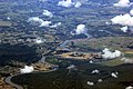
Aerial view of the Sava meander on the Croatian-Bosnian border


Hydrometry
The flow rate of the Sava was measured over 58 years (1926–84) in Sremska Mitrovica almost 100 kilometers above the mouth (in m³ / s).

Web links
Individual evidence
- ↑ a b GRDC - The Save in Sremska Mitrovica
- ↑ Nadiža waterfall. kranjska-gora.si, accessed October 1, 2015.
- ↑ Zelenci. kranjska-gora.si, accessed October 1, 2015.
- ↑ The Periodic Lake Ledine. kranjska-gora.si, accessed October 1, 2015.
- ^ Peter Jordan: Croatia and European integration . In: Albert Hofmayer (Ed.): Contributions to service geography and applied regional economic geography. Festschrift for Univ.-Prof. Dr. Christian Staudacher on his 60th birthday (= Economic Geography Studies . Volumes 30–31). Verlag facultas.wuv / maudrich, 2005, ISBN 3-85114-935-1 , Fig 2.Conventional names (map), p. 80 ( limited preview in Google Book Search - full article, pp. 73–84).