
Syrmia
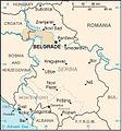
Syrmia ( Serbian Срем Srem , Croatian Srijem , Hungarian Szerémség ) is a landscape between the Danube and Sava rivers . It begins west of Novi Beograd and ends roughly on the length of the mouth of the Drau in the Danube. It is now politically divided between Serbia and Croatia , with the greater part belonging to Serbia. In Serbia, Syrmia is one of the three regions in Vojvodina, along with the Banat and the Batschka, and forms one of the 30 Okruzi . The Croatian part forms the Vukovar-Syrmia County, adjoining the Posavina to the west. In Syrmia there is also the only north Serbian mountain range, the Fruška Gora with the Fruška Gora National Park with its numerous Serbian Orthodox monasteries .
geography

Syrmia extends as an elongated tip of land delimited by the rivers Danube , Save , Vuka and Bosut on the southern edge of the Pannonian lowlands . Despite the modest relief, Syrmia is also a topographically diverse area. Four landscape areas form the Syrmian intercurrent land: the Pannonian island mountains of the Fruška Gora rising up to 541 m , the eastern Syrmian loess plateau and the loess plain in the extreme eastern corner with the terraced plains above the flood plains and finally the alluvial lowlands of the Danube, Sava and Bosut. Geologically, Quaternary aeolian loosens and Holocene alluvial alluvial loam and loess dominate.
history


The name of the region comes from the Roman Sirmium , today Sremska Mitrovica in Serbia.
Roman Empire
The late Roman royal seat of Sirmium was one of the most important cities in the Roman Balkans , seat of the province of Pannonia inferior and during the Tetrarchy also an imperial residence under Galerius . The Danube Limes was a contested border region to the barbarians in late Roman times, and Sirmium remained a key town on the northern Byzantine border of Southeast Europe until the late 6th century.
Avars, Bulgarians and Croats
After the invasion of the Avars and the conquest of Sirmium in 582, as well as the immigration of Slavic tribes in the 7th century, Bulgarians , Byzantines and Avars claimed the fertile region. After 635 it was ruled by the Bulgarian Khan Kuber . Around 688 the native population rose against the Avar supremacy with the Khan, without success.
At the beginning of the 9th century the region was under the rule of Ljudevit of Posavia , Prince of the Pannonian Principality of Croatia .
Byzantine Empire
Under the Macedonians the Byzantines ruled, who established the administrative district of Syrmia under Basil II (10th century) .
Between the 11th and 12th centuries Syrmia was fought over between Byzantium and Hungary , in 1167 Manuel I Komnenus defeated the Hungarians in the battle of Sirmium .
Kingdom of Hungary and Despotate of Serbia
Hungary ruled Syrmia from the 13th century until 1540, but the Serbian King Stefan Dragutin secured a partial kingdom in Upper and Lower Syrmia (today Syrmia or Mačva ) in the late 13th century . The Serbian despots , succeeding Đurađ Branković, resided in the Syrmian town of Kupinovo on Obedska bara . This Syrmian despotate , founded in 1471 under Matthias Corvinus , existed until around 1540. The numerous Serbian Orthodox monasteries of Fruška Gora , founded in the 15th century, became centers of renewal of a Serbian national movement in the 18th century (see Dositej Obradović ).
Ottoman Empire
With the Ottoman subjugation of Hungary, Syrmia became part of the Ottoman Empire .
Habsburg Monarchy
After the Great Turkish War (1683 to 1699), the Austrian Habsburgs ruled , who at the Battle of Peterwardein thwarted the last Turkish effort to recapture Hungary. The Habsburgs assigned the greater part of Syrmia to the military border or the Kingdom of Croatia and Slavonia and settled in several places as well as in the Banat and the Batschka . a. Danube Swabians . At the time of Austria-Hungary , Vukovar was the seat of the Vukovar and Syrmia County (Hungarian "Szerém vármegye") from 1745 .
Yugoslavia
From 1918 Syrmia belonged to the Kingdom of Yugoslavia . 1941-1944 it was annexed to the Independent State of Croatia of the Ustaše . In 1944, in the course of the Belgrade operation and the withdrawal of Army Group E to the position on the Syrmian front , the most costly fighting between the Yugoslav partisans and the German Wehrmacht took place.
In 1945, the Federal Assembly's border determination commission, headed by Milovan Đilas, determined the future course of the border between the Yugoslav republics of Croatia and Serbia on the basis of ethnic criteria in the division of Syria.
Serbia and Croatia
The battle for Vukovar on the territory of the Croatian part of Syrmia, which led to the occupation of Croatian territory and the establishment of the Serbian Autonomous Region of Eastern Slavonia, Baranja and Western Syrmia as part of the Republic of Serbian Krajina , was one of the toughest battles of the entire Yugoslav wars in the 1990s led. In 1998 the occupied territory of western Syrmia was peacefully returned to Croatia in the Erdut Agreement . Many places in the Croatian part of Syrmia are still marked by the armed conflict in 1991.
Population groups
The former multiethnic region of Syrmia arose from the Ottoman and Habsburg settlement policy as well as the migration movements in the aftermath of the World Wars and the Yugoslav Wars of Disintegration. After the formerly important group of Danube Swabians had left their settlement areas in the course of the withdrawal of the Wehrmacht or were expelled, colonists from the poorer karst regions of Yugoslavia (in particular from the Lika , Kordun , Herzegovina and Montenegro ) settled in the fertile region of Syrmia.
During the Yugoslav Wars of Disintegration, Croatian and Serbian war displaced persons left the disputed areas of Syrmia, on the other hand, victims of the war in Bosnia and Croatia in 1994/1995 moved to Syrmia.
Cities and larger municipalities in Syrmia
Croatia : Ilok , Vinkovci , Vukovar , Županja
Serbia : Zemun , Batajnica , Bečmen , Dobanovci , Inđija , Novi Banovci , Nova Pazova , Novi Sad (formerly Petrovaradin and Sremska Kamenica ), Ruma , Sremska Mitrovica , Sremski Karlovci , Stara Pazova , Surčin , Šid , Zemun
District subdivision of the Hungarian county
In the early 20th century, the county consisted of the following chair districts (named after the name of the administrative center):
| Chair districts (járások) | |
|---|---|
| Chair district | Administrative headquarters |
| Ireg | Ireg, today Irig |
| Szávaszentdemeter / Mitrovica | Szávaszentdemeter / Mitrovica, today Sremska Mitrovica |
| Ópázova | Ópázova, today Stara Pazova |
| Sid | Sid, today Šid |
| Újlak | Újlak, today Ilok |
| Vinkovce | Vinkovce, today Vinkovci |
| Vukovár | Vukovár, today Vukovar |
| Zimony | Zimony, today Zemun |
| Zsupanya | Zsupanya, today Županja |
| City district (törvényhatósági jogú város) | |
| Zimony, today Zemun | |
| City districts (rendezett tanácsú városok) | |
| Karlóca, today Sremski Karlovci | |
| Pétervárad, today Petrovaradin | |
| Szávaszentdemeter, today Sremska Mitrovica | |
The places Ilok , Vinkovci , Vukovar and Županja are in present-day Croatia , all the rest in Serbia .
gallery
Syrmia

Division of Syrmia between Croatia and Serbia


See also
- Vojvodina
- Okrug Srem
- Croatia in the Danube Monarchy
- List of historical counties of Hungary
- Viticulture in Serbia
Web links
swell
- ↑ Josef Breu (ed.): Atlas of the Danube countries . Vienna 1970–1989, p. 132.

![]() Central Croatia |
Dubrovnik |
Dalmatia |
Istria |
Slavonia
Central Croatia |
Dubrovnik |
Dalmatia |
Istria |
Slavonia![]()
![]()
![]()
![]()
Other regions
Banovina |
Baranja |
Bilogora |
Bukovica |
Gorski kotar |
Cordun |
Krbava |
Lika |
Međimurje |
Moslavina |
Neretvanska dolina |
Podravina |
Pokuplje |
Posavina |
Prigorje |
Croatian Littoral (Primorje) |
Ravni kotari |
Syrmia |
Zagora |
Zagorje |
Žumberak
Coordinates: 45 ° 10 ′ N , 19 ° 17 ′ E