Virovitica-Podravina County
|
Virovitica-Podravina County Virovitičko-podravska županija |
|||||
|
|||||
| map | |||||
|---|---|---|---|---|---|
| Basic data | |||||
| State : |
|
||||
| Seat : | Virovitica | ||||
| Area : | 2,024 km² | ||||
| Residents : | 84,836 ( 2011 ) | ||||
| Population density : | 42 inhabitants per km² | ||||
| Biggest City : | Virovitica | ||||
| Telephone code : | 033 | ||||
| ISO 3166-2 : | HR-10 | ||||
| NUTS3 code4 : | HR022 | ||||
| Coordinates | 45 ° 52 ′ N , 17 ° 30 ′ E | ||||
| Structure and administration (as of 2013) |
|||||
| Cities : | 3 | ||||
| Municipalities : | 13 | ||||
| Settlements : | 189 | ||||
| Gespan : | Tomislav Tolušić ( HDZ ) | ||||
| Coalition partner : | HSS, HSLS, HSP AS, BUZ | ||||
| Postal address : | Trg Ljudevita Patačića 1 33 000 Virovitica |
||||
| Website : | |||||
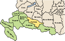
The Virovitica-Podravina County [ ˈʋirɔʋititsa ˈpɔdraʋina ] (Croatian Virovitičko-podravska županija ) is a county in the Croatian region of Slavonia . It is located in northern Slavonia along the Drava on the border with Hungary . It has an area of 2,021 km² and a population of 84,836 (2011 census). The administrative seat is Virovitica .
population
Composition of the population by nationality (data from 2011 census ):
| Ethnicity | number | percent |
|---|---|---|
| Croatians | 77,897 | 91.82% |
| Serbs | 5,144 | 6.06% |
| Albanians | 234 | 0.28% |
| Hungary | 200 | 0.24% |
| Czechs | 104 | 0.12% |
cities and communes
The Virovitica-Podravina County is divided into 3 towns and 13 municipalities. These are listed below with the population at the time of the 2011 census.
Cities
| city | Pop. |
|---|---|
| Orahovica | 5,304 |
| Slatina | 13,686 |
| Virovitica | 21,291 |
Communities
| local community | Pop. |
|---|---|
| Crnac | 1,456 |
| Čačinci | 2,802 |
| Čađavica | 2,009 |
| Gradina | 3,850 |
| Lukač | 3,634 |
| Mikleuš | 1,464 |
| Nova Bukovica | 1,771 |
| Pitomača | 10,059 |
| Sopje | 2,320 |
| Suhopolje | 6,683 |
| Špišić Bukovica | 4.221 |
| Voćin | 2,382 |
| Zdenci | 1,904 |


