
Herzegovina

The Herzegovina ( Bosnian / Croatian / Serbian Херцеговина / Hercegovina ) is a region in the southwest of the state of Bosnia and Herzegovina . With 12,276 km², it covers around a quarter of the national territory , with partly variable borders with Bosnia . The main town of Mostar is located in the catchment area of the Neretva River .
Characterized by Dinarics with its karst landscape and the embedded fertile valleys ( Polje ) that Herzegovina is bordered to the north of Bosnia, the south and southwest of Croatia and in the south-east of Montenegro . It has access to the Adriatic Sea at Neum .
Since the Dayton Agreement of 1995, Herzegovina has been administratively divided between the Federation of Bosnia and Herzegovina in the west with a predominantly Croatian population and the Republika Srpska in the east with a predominantly Serbian population, each mixed by Bosniaks .
The historical landscape was created by the union of the two principalities of Zahumlje (west with the Neretva valley) and Travunia (east) under the ruler Sandalj Hranić Kosača († 1435). His subsequent nephew, Stjepan Vukčić Kosača , took on the title of duke in 1448 , from whose German name Herzog (in the national languages: herceg ) the name Hercegovina (" Herzogsland ") is derived. Its territory, the Duchy of St. Sava ( Latin: Ducatus Sancti Sabae ), was after the conquest by the Ottoman Empire (1465-1470) in Turkish with Hersek Sancağı (German: Sandschak Herzegovina , Bosnian: Sandžak Hercegovina ) and from 1833 Hersek Eyaleti and also referred to as Turkish (es) Dalmatia in German .
geography

The original territory of Herzegovina as part of the Ottoman Empire comprised the 15 districts ( Nahiya or Kadiluks ) in the 19th century : Duvno ( Županjac ), Ljubuški, Konjic, Mostar, Blagaj , Počitelj , Stolac, Trebinje (with Ljubinje), Nevesinje, Gacko, Nikšić , Foča , Čajniče , Plevlje (with Kolašin ), and Prijepolje . Since that time, peripheral districts and border landscapes have been partly with Montenegro ( Grahovo , Banjani , Nikšić, Piva , Drobnjak and Šaranci ), with the Sanjak Novi Pazar (Plevlje, Prijepolje, Bijelopolje and Kolašin) and with Bosnia (Foča, Goražde and Čajničde) been united.
The territory of Herzegovina can currently be determined geographically on the basis of historical, economic, social and cultural criteria. According to this, the municipalities Berkovići , Bileća , Čapljina , Čitluk , Gacko , Grude , Jablanica , Konjic , Kupres and Kupres (RS) , Livno , Ljubinje , Ljubuški , Međugorje , Mostar and Istočni Mostar , Neum , Nevesinje , Posušje , Proz Rama , Ravno , Stolac , Široki Brijeg , Tomislavgrad and Trebinje . The naming of these municipalities (with the exception of Kupres) coincides with the law on the division of the territory of the People's Republic of Bosnia and Herzegovina passed in 1952 by the National Assembly of Bosnia and Herzegovina; Even then, the communities of Tomislavgrad (then Duvno) and Livno were assigned to Herzegovina. In the Great Geographical Atlas of Yugoslavia 1987, the region is also identified with these aforementioned municipalities (with the exception of Kupres).
Herzegovina is a mountainous country that is characterized by the barren mountain ranges of the Dinaric Mountains . Extensive karst landscapes with oasis-like fertile lowlands ( polje ) are typical . The climate is influenced by the Mediterranean , but the amount of precipitation is greater than in other regions of this climate. The winters are mild; In contrast to Bosnia to the north, it rarely snows in the valleys of Herzegovina. Summers are dry and hot, especially in July and August.
mountains

The Volujak (2336 m) is the country's second highest mountain in Herzegovina, more precisely in the Gacko community . Other high mountains are the Čvrsnica (2226 m) near Posušje and the Prenj (2226 m) near Mostar.
Lakes

Hercegovina is characterized by smaller lakes in the Poljen (karst plains), which are or were sometimes surrounded by extensive swamps. The largest and at the same time the highest natural lake is the Blidinje jezero (3.2 km²), which is 1180 m above sea level on a plateau in the municipalities of Posušje and Tomislavgrad. Other important lakes are the Hutovo Blato wetland and the Jablaničko jezero , Ramsko jezero and Buško jezero reservoirs .
Rivers
The only larger river is the Neretva , which rises north of Gacko and then flows through the whole of Herzegovina in a wide arc over a length of 218 km. The southern part of the country lies in the catchment area of the smaller Trebišnjica , which arises on the Montenegrin border and disappears after 96.5 km near Hutovo in the Karst.
Cities
Significant places in Herzegovina are Bileća , Čapljina , Gacko , Stolac and Trebinje in the south and Čitluk , Grude , Ljubuški , Međugorje , Široki Brijeg , Mostar and Posušje in the west of Herzegovina. The largest towns in the north are Jablanica and Konjic ; the east and the center of the landscape are very sparsely populated.
history
antiquity
The earliest known inhabitants of the Herzegovina area were the Illyrians , who were mainly cattle breeders and as such lived mainly on sheep, pigs and goats. In the 1st and 2nd centuries, the Romans conquered the Illyrian territories. In 9 AD they put down the last uprising of the Daesitates tribe in central Bosnia and from then on they had the area under their control. A Roman network of roads and settlements was created, which was primarily used for military operations, but also for the extraction of natural resources in Bosnia. The area of the later Herzegovina was part of the Roman province of Dalmatia . Settlers came to Dalmatia from all over the Roman Empire, including Italy, Africa, Spain, Gaul, Germania, Greece, Asia Minor, Syria, Palestine and Egypt. Asian names are also found in documents found in the Neretva valley. The Christianity reached the Roman towns in Herzegovina early. Coins from the 4th century were found in the remains of a Roman basilica near Stolac - an indication that the phase of this early Christianity ended with the penetration of the Goths in the 3rd century. The territory of Herzegovina then belonged to the Ostrogoth kingdom . Justinian was only able to drive out the Goths again in the 6th century .
middle Ages

The Avars and Slavs immigrated in the 6th century . In the 7th century the Slavic tribes of Croatians and Serbs immigrated. The Croats because they were called by the Byzantine Emperor to drive out the Avars, the Serbs because they were connected with the Croats and therefore immigrated with them. The Avars were eventually driven from the Balkan Peninsula by Byzantine, Croatian and Bulgarian armies in the 7th century. Since the immigration of the Slavs, the region of Herzegovina, between the 7th and 11th centuries, was mostly under the influence of the Byzantine Empire .
In the Middle Ages, the Duchy of Zahumlje was in the area of central Herzegovina , depending on Byzantium, Bosnia and Serbia , and in eastern Herzegovina and northern Montenegro the Duchy of Travunia , which became part of Croatia in the 11th century , and Serbia from 1180 to 1321 (" Raszien ") belonged and was divided between Bosnia and Serbia from 1322 to 1377. Saint Sava , founder of the Serbian Orthodox Church , was governor of Hum before he renounced worldly life and became a monk. The western part, on the other hand, belonged to Croatia for almost the entire Middle Ages and is still largely inhabited by Croats.
In 1326, the Bosnian prince Stjepan II. Kotromanić annexed the land of Hum and thus united Bosnia for the first time with the heartland of the later Herzegovina to form a political unit. Travunia remained with the Serbia of the Nemanjids . With the collapse of the Serbian Empire , Prince Nikola Altomanović established himself in Travunia , who claimed the Serbian tsar's crown for himself. Altomanović conquered large areas in western central Serbia before he was defeated in 1373 by a joint action of the Bosnian prince and later king Tvrtko I and the Serbian prince Lazar and his territory was divided between the victors; Travunia itself fell to Bosnia. In 1388, for the first time, a division of the Ottomans advanced into Hum, ruled by Bosnia, in order to plunder. It was destroyed by troops led by the local nobleman Vlatko Vuković , who only one year later also led the strong Bosnian army in the battle of the Blackbird Field.
.jpg)
In the 15th century , the Ottoman military incursions into Bosnia increased, which led to an increase in power for Stjepan Vukčić Kosača , the ruler of Hum. After the death of the Bosnian king Tvrtko II in 1443, he refused to recognize his successor Stjepan Tomaš . After a subsequent war of several years, an agreement was reached in 1446. However, Vukčić continued to support the Serbian ruler Đurađ Branković , who, as a semi-independent vassal of the Ottomans, fought with the Bosnian king for the area of Srebrenica . To emphasize his independence, Vukčić gave himself in 1448 the title "Duke of Hum and the Coast", which he later changed to "Duke of St. Sava ". The current name of the country goes back to the title of duke adopted by Vukčić . In the early 1450s, Vukčić was not only involved in a war with Ragusa , but also in a civil war with his eldest son. Before the spring of 1453, the head of the Bosnian Church left the territory of Bosnia to flee with 40 followers to Stjepan Vukčić Kosača in Herzegovina and to convert to the Orthodox Church in the same year. In 1462 the civil war between Vukčić and his eldest son flared up again after he had asked the Ottomans to attack Herzegovina when they planned to attack Bosnia.
Modern times and Ottoman era

In 1463, the last Bosnian king Stjepan Tomašević submitted to the Ottoman Empire and was executed. His wife Katarina Kosača-Kotromanić fled to Rome , where she died in 1478. In her will she left Bosnia to her children in case they returned to the Catholic faith; otherwise their land should fall to the Holy See , the latter then occurred.
An increasingly smaller core of Herzegovina also held out against the Ottomans after 1463. In 1465, Herzegovina was also largely conquered by the Ottoman Empire. The "Herceg" Stjepan Vukčić Kosača had to take refuge in the fortified port of Novi, where he died in 1466. The port was renamed Herceg Novi in his honor . His second son Vlatko inherited the title of duke and tried to defend the remnants of Herzegovina with Hungarian and Ragusan help. From the 1470s he had to pay tribute to the Ottomans and in 1481 or 1482 the Ottomans took the last fortress on Herzegovinian territory. As early as 1470, Herzegovina became part of the Eyâlet Rumelia within the Ottoman Empire as a Sandschak , like the Sandschak Bosnia before . This Sanjak Herzegovina ( Hersek Sancağı ) with the capital Mostar, became part of the Paschalik Bosnia ( Bosna Eyâleti ) in 1580 . From 1833 to 1851, Herzegovina was again separated from Bosnia and elevated to Paschalik Herzegovina ( Eyâlet-i Hersek ), with a certain degree of independence. After it had been re-annexed to Bosnia in the meantime, Herzegovina again became an administrative unit of equal value as Vilayet Herzegovina ( Hersek Vilayeti ) alongside Vilayet Bosnia through the Ottoman administrative reform in 1864 . Cities like Mostar and Stolac formed important trading posts between Dubrovnik and the interior.
Austro-Hungarian occupation to this day


.svg)
As a result of the Berlin Congress in 1878, most of Herzegovina came under Austro-Hungarian administration as part of Bosnia-Herzegovina . The easternmost part of the former Ottoman province Herzegovina, however, came to Montenegro , to which this area, the so-called Old Herzegovina ( Stara Hercegovina ), still belongs today. In 1908 Austria-Hungary annexed Bosnia and its part of Herzegovina. In terms of administrative law, Herzegovina was then one of six districts in Bosnia. This so-called Mostar district comprised ten districts with 219,511 inhabitants on 9119 square kilometers. The international tensions, which were exacerbated by the annexation, can be seen as an important step on the way to the First World War . (See also: Bosnian annexation crisis .)
Herzegovina was part of Yugoslavia since 1918 . During the time of the Kingdom of Yugoslavia (1929 to 1941) and its predecessor, the Kingdom of Serbs, Croats and Slovenes (1918 to 1929), Herzegovina was divided between the newly formed Zeta and Coast banks after 1929 . From 1939 to 1941 the coast and with it the western Herzegovina belonged to the Croatian bank , while the eastern Herzegovina remained in the Zeta bank. After the Balkan campaign of the German Empire and the capitulation of the Kingdom of Yugoslavia in 1941, Herzegovina became part of the Independent State of Croatia . After the Second World War , the whole of Herzegovina became part of the Socialist Republic of Bosnia and Herzegovina within what is now communist Yugoslavia.

In the Balkans conflict , Herzegovina was one of the main theaters of war. In 1991 Dubrovnik was bombed from the south of the country by troops of the Yugoslav People's Army (JNA). When the Bosnian War broke out in 1992 , there were bloody clashes, at first only between Serbs on one side and Bosniaks and Croats on the other. However, when the Croatians of Bosnia and Herzegovina proclaimed the Republic of Herceg-Bosna , there was also fighting between Bosniaks and Croats, resulting in so-called ethnic cleansing . During these fighting, the famous Old Bridge of Mostar was probably destroyed by Croatian HVO forces in 1993 . Since then, Mostar has become a divided city and communication between the Bosniak East and the Croatian West Mostar was almost completely cut off. The reconstruction of the bridge began in 1996 and was completed in 2004.
It was not until January 2004, at Paddy Ashdown's insistence, that a regulation was made through which Mostar became a single administrative unit again, albeit with a special status and strict protection conditions.
Today Herzegovina is politically divided into three parts: The east around Trebinje is part of the Republika Srpska . West, middle and north belong to the Federation of Bosnia-Herzegovina , with the west forming the Croatian canton West-Herzegovina and north and center around Mostar the binational (Bosniak-Croatian) canton Herzegovina-Neretva .
gallery

Mostar, with the bridge over the Neretva ( Stari most )

Mostar, eastern old town with a view of a war-torn building

Kravica waterfalls near Ljubuški
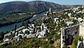
Počitelj , view of the city


.jpg)


See also
- Bosnia
- Herzegovinians
- Vilâyet Herzegovina (Province of the Ottoman Empire, from 1864)
- Paschalik Herzegovina (Province of the Ottoman Empire, 1833–1851)
- History of Bosnia and Herzegovina
literature
- Holm Sundhaussen : Herzegovina . In: Lexicon on the history of Southeast Europe . 2nd expanded and updated edition. Böhlau Verlag, Vienna / Cologne / Weimar 2016, ISBN 978-3-205-78667-2 , p. 385 ff .
- Heiner Grunert: Faith in the hinterland. The Serbian Orthodox in Habsburg Herzegovina 1878–1918 . V&R, Göttingen 2016, ISBN 978-3-525-31029-8 .
- NIRO “Privredni vjesnik” (Ed.): Hercegovina . Zagreb 1981.
- Mato Njavro: Hercegovina: Povijest, kultura, umjetnost, prirodne znamenitosti, turizam . Privredni vjesnik, Zagreb 1985.
- Noel Malcolm: History of Bosnia . S. Fischer Verlag, Frankfurt am Main 1996, ISBN 3-10-029202-2 .
- Hrvatski institut za povijest (ed.): Hum i Hercegovina kroz povijest . Zagreb 2011, ISBN 978-953-6324-96-5 .
Web links
Individual evidence
- ↑ a b Map of Herzegovina on redah.ba. REDAH ( Regionalna razvojna agencija za Hercegovinu = Regional Development Agency for Herzegovina) is an organization that promotes economic development in the region. It was founded in 2003 by the mayors of 23 municipalities and local business representatives (see information on REDAH )
- ↑ So already determined geographically by Ivan Bertić (ed.): Veliki geografski atlas Jugoslavije . Sveučilišna naklada Liber, Zagreb September 1987, p. 10 f . , with the exception of Kupres.
- ↑ Sundhaussen 2016, p. 385 (see literature).
- ^ Franz Heinrich Ungewitter: Turkey in the present, future and past . Verlag by JJ Palm and Ernst Enke, Erlangen 1854, p. 11-12 .
- ^ Carl Patsch: From Herzegovina's last feudal period . In: Communications from the Geographical Society in Vienna . Vienna 1921, p. 155.
- ^ Službeni list Narodne republike Bosne i Hercegovine . Vol. VIII, No. 11 , May 5, 1952, pp. 69 . Quoted from Adnan Velagić: Administrativno uredjenje Hercegovine od 1945. do 1952. godine . In: Most: časopis za obrazovanje, nauku i kulturu . 191 (102 new). Mostar 2005, p. 82-84 ( most.ba ).
- ↑ Ivan Bertić (Ed.): Veliki geografski atlas Jugoslavije . Sveučilišna naklada Liber, Zagreb September 1987, p. 10 f .
- ^ Noel Malcolm: History of Bosnia . S. Fischer Verlag, Frankfurt am Main 1996, p. 20 ff.
- ^ Noel Malcolm: History of Bosnia . S. Fischer Verlag, Frankfurt am Main 1996, p. 35.
- ^ Noel Malcolm: History of Bosnia . S. Fischer Verlag, Frankfurt am Main 1996, p. 38.
- ^ Noel Malcolm: History of Bosnia . S. Fischer Verlag, Frankfurt am Main 1996, p. 40 f.
- ^ Noel Malcolm: History of Bosnia . S. Fischer Verlag, Frankfurt am Main 1996, p. 60 f.
- ^ Noel Malcolm: History of Bosnia. S. Fischer Verlag, Frankfurt am Main 1996, p. 63 f.
- ^ Noel Malcolm: History of Bosnia . S. Fischer Verlag, Frankfurt am Main 1996, p. 70.