
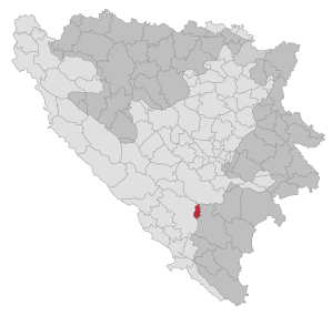
Istočni Mostar
|
Istočni Mostar Источни Мостар |
|||
|
|||
| Basic data | |||
|---|---|---|---|
| State : | Bosnia and Herzegovina | ||
| Entity : | Republika Srpska | ||
| Municipality : | Istočni Mostar | ||
| Coordinates : | 43 ° 25 ' N , 18 ° 0' E | ||
| Height : | 810 m. i. J. | ||
| Area : | 88 km² | ||
| Residents : | 243 (2018) | ||
| Population density : | 3 inhabitants per km² | ||
| Structure and administration (as of 2016) | |||
| Mayor : | Božo Sjeran ( SDS ) | ||
  |
|||

Istočni Mostar ( Serbian - Cyrillic Источни Мостар ), previously Srpski Mostar (Српски Мостар) is an Opština (union community) in the southern part of the Republika Srpska in Herzegovina . The municipality was created when the districts east of the Velež mountain range were separated from Mostar as a result of the 1995 Dayton Treaty .
The name translates into German as "East Mostar", but should not be confused with the East Mostar district in Mostar itself. The name Srpski Mostar (Serbian Mostar), which the municipality carried until 2004, was banned by the Constitutional Court of the Republic of Bosnia and Herzegovina due to its ethnic reference.
Geography and infrastructure
The municipality consists of three spatially separated areas: In the north the largest and most populous Zijemlje (187 inhabitants in 2013) with the administrative center and the two exclaves Kamena (67 inh.) And Kokorina (3 in.) Further south.
The district of Zijemlje is located 17 kilometers northeast of the city center of Mostar in Vilino polje , but is separated from the city by the almost 2000 m high Velež mountain range and cannot be reached via paved roads.
There is no school in the community; the children attend school in Nevesinje, 30 kilometers away .
population
In 1991 the district of Zijemlje had 153 inhabitants, 95 of whom referred to themselves as Serbs and 57 as Bosniaks.
Since the local elections on October 7, 2012, seven representatives of the SDS , three of the DP and one representative of the SDA have been on the municipal council .
Web link
Individual evidence
- ↑ http://rzs.rs.ba/front/article/3630/ Updated population figures for 2018 from the Institute for Statistics of the Republika Srpska. Retrieved June 9, 2019.

Banja Luka | Banovići | Berkovići | Bihać | Bijeljina | Bileća | Bos. Krupa | Bos. Brod | Bos. Petrovac | Šamac | Bos. Grahovo | Bratunac | Brčko | Breza | Bugojno | Busovača | Bužim | Cazin | Centar | Čajniče | Čapljina | Čelić | Čelinac | Čitluk | Derventa | Drvar | Doboj | Doboj Istok | Doboj Jug | Dobretići | Domaljevac-Šamac | Donji Vakuf | Donji Žabar | Foča | Foča-Ustikolina | Fojnica | Gacko | Glamoč | Goražde | Gornji Vakuf-Uskoplje | Gračanica | Gradačac | Gradiška | Grude | Hadžići | Han Pijesak | Ilidža | Ilijaš | Istočna Ilidža | Istočni Drvar | Istočni Mostar | Istočni Stari Grad | Istočno Novo Sarajevo | Jablanica | Jajce | Jezero | Kakanj | Kalesija | Kalinovik | Kiseljak | Kladanj | Ključ | Kneževo | Konjic | Kostajnica | Kotor Varoš | Kozarska Dubica | Kreševo | Krupa na Uni | Kupres | Kupres (RS) | Laktaši | Livno | Ljubinje | Ljubuški | Lopare | Lukavac | Maglaj | Milići | Modriča | Mostar | Mrkonjić degree | Neum | Nevesinje | Novi Grad | Novi Grad (Bos. Novi) | Novi Travnik | Novo Sarajevo | Odžak | Olovo | Orašje | Osmaci | Oštra Luka | Pale | Pale-Prača | Pelagićevo | Petrovac | Petrovo | Posušje | Prijedor | Prnjavor | Prozor-Rama | Ravno | Ribnik | Rogatica | Rudo | Sanski Most | Sapna | Sokolac | Srbac | Srebrenica | Srebrenik | Stari Grad | Stanari | Stolac | Šekovići | Šipovo | Široki Brijeg | Teočak | Teslić | Tešanj | Tomislavgrad | Travnik | Trebinje | Trnovo (RS) | Trnovo (FBiH) | Tuzla | Ugljevik | Usora | Ustiprača | Vareš | Velika Kladuša | Visoko | Višegrad | Vitez | Vlasenica | Vogošća | Vukosavlje | Zavidovići | Zenica | Zvornik | Žepče | Živinice