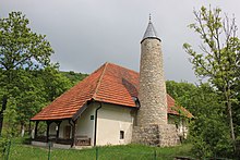
Trnovo
|
Trnovo Трново |
||
|
|
||
| Basic data | ||
|---|---|---|
| State : | Bosnia and Herzegovina | |
| Entity : | ||
| Canton : | ||
| Coordinates : | 43 ° 40 ' N , 18 ° 27' E | |
| Height : | ||
| Area : | 135 km² | |
| Residents : | 4,022 (2013) | |
| Population density : | 30 inhabitants per km² | |
| Telephone code : | +387 (0) 58 | |
Trnovo ( Cyrillic Трново ) is a place in the east of Bosnia and Herzegovina . The unified parish of the same name was separated into several parts in 1995 by the entity boundary set out in the Dayton Treaty . While the northern and southern parts of the municipality today belong to the municipality of Trnovo (RS) in the Republika Srpska , the middle part forms the municipality of Trnovo (FBiH) in the canton of Sarajevo . The place Trnovo itself is also divided between the two entities.
The place name comes from the Serbo-Croatian word trnov for "thorny".
geography
The place Trnovo lies in the valley basin of the Željeznica between the mountain ranges of the Jahorina in the east, the Treskavica in the south and the Bjelašnica in the west at an altitude of 800 to 850 m. The community extends from 600 to 1700 m altitude. Parts of the northern municipality belong to the Jahorina National Park .
The municipality of Trnovo (RS) consists of two spatially separate parts of the municipality. The northern part of the municipality around Jablanica and Kijevo and the southern part of the municipality around Trnovo are separated from each other by the federation's area corridor, which is about 6 km wide . The corridor is the connection between Goražde and the rest of the Federation.
The northern part of the municipality borders on the municipalities of Istočna Ilidža ( East Ilidža ) and Istočno Novo Sarajevo ( East New Sarajevo ) in the north, Pale in the east and Trnovo (FBiH) in the south. The southern part of the municipality borders on Trnovo (FBiH) in the north and Kalinovik in the south.
Trnovo (RS) in the north and south, Pale in the north-east, Foča-Ustikolina in the far east, Konjic in the south-west and Ilidža and Hadžići in the north-west border the municipality of Trnovo (FBiH) .
Community structure
The municipality of Trnovo (RS) includes the settlements Bogatići, Grab, Jablanica, Kijevo, Klanac, Milje, Podivič, Rajski Do, Tošići, parts of Trnovo, Turovi, Ulobići and Vrbovnik. The remaining 50 settlements belong to the Trnovo municipality (FBiH).
population
At the 1991 census, the entire municipality of Trnovo (6 village communities) had 6,991 inhabitants; 4,790 (68.81%) of these were Bosniaks and 2,059 (29.45%) Serbs .
At the 2013 census there were 2,192 inhabitants in the municipality of Trnovo (RS) and 1,830 in the federation municipality.
history
During the Bosnian War , the area of the Trnovo municipality was fought over. On the one hand, the army of the Republika Srpska used the M18 coming from the south during the siege of Sarajevo as a supply route for their troops in the main combat areas on the Igman and Jahorina ; on the other hand, the domination of the Trnovo valley meant the control of the southern access to Sarajevo.
From May to July 1992 the VRS held the place before it was captured by the ARBiH after heavy fighting . In the summer of 1993, the Serbian armed forces were able to recapture parts of it. After the end of the war, all places in the municipality were largely destroyed.
economy
Industry traditionally does not play a major role in the wooded, mountainous area south of Sarajevo. The main industries before the war were forestry and wood processing . Many residents commuted to Sarajevo every day.
traffic
Trnovo is located on the M18 trunk road about 35 km south of Sarajevo and 50 km west of Foča. At the southern border of the municipality, the road crosses the 1161 m high Rogoj pass . The Sarajevo airport is located 25 km from Trnovo.
Cultural monuments
The old Umoljani mosque and six medieval necropolises with Stećci in Delijaš, Prečani, Ledići and Umoljani are recognized as national cultural monuments in the Trnovo municipality .


