Lyubinje
|
Ljubinje Љубиње |
||
|
|
||
| Basic data | ||
|---|---|---|
| State : | Bosnia and Herzegovina | |
| Entity : | Republika Srpska | |
| Coordinates : | 42 ° 57 ' N , 18 ° 5' E | |
| Height : | ||
| Area : | 321 km² | |
| Residents : | 3,187 (2018) | |
| Population density : | 10 inhabitants per km² | |
| Telephone code : | +387 (0) 59 | |
| Postal code : | 88380 | |
| Structure and administration (as of 2016) | ||
| Mayor : | Darko Krunić ( DNS ) | |
| Website : | ||
Ljubinje ( Serbian - Cyrillic Љубиње ) is a municipality in Bosnia-Herzegovina . It is located in the south of the Republika Srpska and borders the municipalities of Trebinje , Bileća and Berkovići in the Republika Srpska and Stolac , Neum and Ravno in the Federation of Bosnia and Herzegovina . The municipality of Ljubinje has almost 3,800 inhabitants on an area of 326 km². In the city center is the Serbian Orthodox Church of the Nativity , built in 1866 .
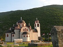
In 2000 it was decided to have a new Serbian Orthodox Church built in honor of Jesus Christ. On June 11, 2000, the foundation stone of the church designed by the architect Ljubiša Folić was laid. After 4 years of construction, the church (see picture above) was consecrated on September 21, 2004.
The municipalities of Ljubinje include the villages Bančići, Vlahovići, Vođeni, Gleđevci, Srbac-Grablje, Gradac, Dubočica, Žabica, Žrvanj, Ivica, Kapavica, Krtinje, Kruševica, Krajpolje, Mišljen, Obzir, Pocrnje, Pustipci and Ubuskoos.
The area around Ljubinje has been settled for a long time and is mentioned in writing in documents as early as the end of the 14th and beginning of the 15th century. Important trade routes from Dubrovnik and the Neretva Basin ran through this area to the north and east.
Web links
Individual evidence
- ↑ http://rzs.rs.ba/front/article/3630/ Updated population figures for 2018 from the Institute for Statistics of the Republika Srpska. Retrieved June 9, 2019.


