
Vlasenica
|
Vlasenica Власеница |
|||
|
|
|||
|
|||
| Basic data | |||
|---|---|---|---|
| State : | Bosnia and Herzegovina | ||
| Entity : | Republika Srpska | ||
| Coordinates : | 44 ° 11 ' N , 18 ° 56' E | ||
| Height : | 500 m. i. J. | ||
| Area : | 220 km² | ||
| Residents : | 10,283 (2018) | ||
| Population density : | 47 inhabitants per km² | ||
| Telephone code : | +387 (0) 56 | ||
| Postal code : | 75440 | ||
| Structure and administration (as of 2016) | |||
| Mayor : | Miroslav Kraljević ( SNSD ) | ||
| Website : | |||
  |
|||


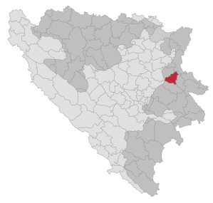
Vlasenica ( Serbian - Cyrillic Власеница ) is a city and the administrative seat of the municipality of the same name in the east of the Republika Srpska in Bosnia and Herzegovina . The place name comes from the Serbo-Croatian word vlas (in German "hair"). Vlasenica means something like "hairpin". The trunk road to Sarajevo climbs on the southern edge of the city in tight hairpin bends in the direction of the Pogled Pass.
geography
The municipality of Vlasenica is located in a mountainous area by the Tišća river , a tributary of the Drinjača . The municipality extends from the ridge of the Javor Mountains in the south to the Donji Birač ridge and the Drinjača in the north over a width of about 20 km between 400 (in the east) and 1400 m in height (in the south).
The municipality is bounded by the association municipalities Šekovići and Zvornik in the north, Bratunac and Milići in the east, Han Pijesak in the south and Kladanj in the west. The border to the municipality of Kladanj is also the inner Bosnian entity border .
Community structure
The municipality includes 38 settlements, which are assigned to the 9 local communities Cerska, Cikote, Donji Zalukovik, Gorni Zalukovik, Gradina, Mišari, Piskavice, Simići and Vlasenica. Until 1992, the neighboring municipality of Milići with 5 local communities and 54 settlements belonged to Vlasenica. It split off on April 21, 1992 after the referendum on the country's independence in the run-up to the Bosnian War .
population
At the 1991 census, the municipality (with Milići) had 33,942 inhabitants. Of these, 18,727 identified themselves as Bosniaks (55.17%) and 14,359 as Serbs (42.3%). 856 residents (2.52%) stated other affiliations. Without Milići, the municipality had 17,904 inhabitants, including 12,573 Bosniaks (70.22%) and 6,752 Serbs (37.71%).
At that time, 7,909 people lived in the town of Vlasenica itself. Here, too, the Bosniaks made up the absolute majority with 4800 inhabitants (60.69%). 2743 inhabitants described themselves as Serbs (34.68%). Local communities with a Serb majority were Gornji Zalukovik (97.26%), Mišari (74.36%) and Simići (94.58%).
Today the population of the structurally weak municipality is almost a third lower than in 1991.

history
The area around Vlasenica belonged to the Kingdom of Bosnia from the first half of the 13th century ; The important Borač castle was located in the vicinity of the town .
After the annexation of Bosnia by Austria-Hungary in 1878, Vlasenica became a garrison town . Here was the 1st Battalion of the Hungarian Infantry Regiment No. 62 “Ludwig III. King of Bavaria ”stationed.
During the Bosnian War , Vlasenica initially belonged to the areas with an insecure majority of the population. In January 1992, various Serbian personalities from the region declared several municipalities - including Vlasenica - to be the Serbian Autonomous Region of Birač . Milenko Stanić from Vlasenica was appointed "Prime Minister" of this self-appointed state. Between April 20 and 26, 1992, the JNA and Serbian militias took control of the city. Shortly afterwards, 83 Bosniaks were murdered in the eastern district of Zaklopača.
The Bosniak population group, which previously made up the majority, was almost without exception expelled between May and October 1992 in the direction of Kladanj and Tuzla or deported to the front by bus. Bosniaks who refused to leave the city were arrested and held in the Sušica camp . Vlasenica was also the headquarters of the VRS Drina Corps . After the war, the community was initially inhabited exclusively by Bosnian Serbs, among them about 7000 refugees from other parts of the country. The main battle line ran through the western part of the community. Larger areas there are still mined . The villages around Cerska in the northeast of the municipality as well as the Jarovlje settlement suffered the greatest destruction.
The first witness interview carried out on October 9, 1995 at the ICTY in The Hague dealt with the Šušica camp in Vlasenica in connection with the indictment against its guard commander Dragan Nikolić (1957-2018).
In December 1998, following the arrest of VRS General Radislav Krstić by SFOR in Vlasenica, there were temporary demonstrations and tumultuous gatherings.
Today Austrian EUFOR soldiers are stationed in Vlasenica .
economy
Large parts of the municipality - around four fifths - are densely forested. Agriculture is only possible to a limited extent. However, the city was an industrial site before the war. The largest employer was the ALPRO aluminum processing plant , which depended on the bauxite mine in Milići.
traffic
Vlasenica is connected to Sarajevo (84 km) and Zvornik (50 km) via the M19 trunk road . The first road on this route opened in 1879. In the city, the M19.2 branches off in a north-westerly direction to Tuzla (85 km). There is no railway connection.
Personalities
- Flory Jagoda (* 1925), singer of Sephardic music, grew up in Vlasenica
- Radislav Krstić (* 1948), commandant of the VRS Drina Corps at the time of the Srebrenica massacre
- Velibor Đurić (* 1982), football player
- Vedad Ibišević (* 1984), football player
swell
- Report by the Federal Commissioner for Bosnia ( Memento from 23 August 2009 in the Internet Archive )
- James Gow : The Serbian project and its adversaries ; C. Hurst & Co. 2003; Pages 124, 127, 129, 133, 134.
- ↑ http://rzs.rs.ba/front/article/3630/ Updated population figures for 2018 from the Institute for Statistics of the Republika Srpska. Retrieved June 9, 2019.
- ↑ Calculations from the results of the 1991 census
- ↑ Vjekoslav Klaic: Bosnian history , page 26th
- ↑ Ivana Nizich: War crimes in Bosnia-Hercegovina. Helsinki Watch 1992, p. 35
- ^ Friedrich Jäger: The international tribunal on war crimes in the former Yugoslavia , LIT Verlag Berlin-Hamburg-Münster 2005, page 118.
Web links

Banja Luka | Banovići | Berkovići | Bihać | Bijeljina | Bileća | Bos. Krupa | Bos. Brod | Bos. Petrovac | Šamac | Bos. Grahovo | Bratunac | Brčko | Breza | Bugojno | Busovača | Bužim | Cazin | Centar | Čajniče | Čapljina | Čelić | Čelinac | Čitluk | Derventa | Drvar | Doboj | Doboj Istok | Doboj Jug | Dobretići | Domaljevac-Šamac | Donji Vakuf | Donji Žabar | Foča | Foča-Ustikolina | Fojnica | Gacko | Glamoč | Goražde | Gornji Vakuf-Uskoplje | Gračanica | Gradačac | Gradiška | Grude | Hadžići | Han Pijesak | Ilidža | Ilijaš | Istočna Ilidža | Istočni Drvar | Istočni Mostar | Istočni Stari Grad | Istočno Novo Sarajevo | Jablanica | Jajce | Jezero | Kakanj | Kalesija | Kalinovik | Kiseljak | Kladanj | Ključ | Kneževo | Konjic | Kostajnica | Kotor Varoš | Kozarska Dubica | Kreševo | Krupa na Uni | Kupres | Kupres (RS) | Laktaši | Livno | Ljubinje | Ljubuški | Lopare | Lukavac | Maglaj | Milići | Modriča | Mostar | Mrkonjić degree | Neum | Nevesinje | Novi Grad | Novi Grad (Bos. Novi) | Novi Travnik | Novo Sarajevo | Odžak | Olovo | Orašje | Osmaci | Oštra Luka | Pale | Pale-Prača | Pelagićevo | Petrovac | Petrovo | Posušje | Prijedor | Prnjavor | Prozor-Rama | Ravno | Ribnik | Rogatica | Rudo | Sanski Most | Sapna | Sokolac | Srbac | Srebrenica | Srebrenik | Stari Grad | Stanari | Stolac | Šekovići | Šipovo | Široki Brijeg | Teočak | Teslić | Tešanj | Tomislavgrad | Travnik | Trebinje | Trnovo (RS) | Trnovo (FBiH) | Tuzla | Ugljevik | Usora | Ustiprača | Vareš | Velika Kladuša | Visoko | Višegrad | Vitez | Vlasenica | Vogošća | Vukosavlje | Zavidovići | Zenica | Zvornik | Žepče | Živinice