
Sarajevo
|
Sarajevo Сарајево |
|||
|
|
|||
|
|||
| Basic data | |||
|---|---|---|---|
| State : | Bosnia and Herzegovina | ||
| Entity : | Federation of BiH | ||
| Canton : | Sarajevo | ||
| Coordinates : | 43 ° 52 ' N , 18 ° 26' E | ||
| Height : | 511 m. i. J. | ||
| Area : | 141.5 km² | ||
| Residents : | 291,422 (2013) | ||
| Agglomeration : | 515,368 (2013) | ||
| Population density : | 2,060 inhabitants per km² | ||
| Telephone code : | +387 (0) 33 | ||
| Postal code : | 71000 | ||
| Structure and administration (status: 2018) | |||
| Community type: | city | ||
| Mayor : | Abdulah Skaka, SDA ( SDA / SBB ) | ||
| Postal address : | Hamdije Kreševljakovića 3 71000 Sarajevo |
||
| Website : | |||
| Others | |||
| City Festival : | April 6th ("Sarajevo City Day") | ||


Sarajevo ( Cyrillic Сарајево; German also Sarajewo ; pronunciation: [ ˈsarajeʋo ]) is the capital and seat of government of Bosnia and Herzegovina , the Federation of Bosnia and Herzegovina ( Federacija Bosne i Hercegovine / FBiH) and the canton of Sarajevo .
The city has 291,422 inhabitants in its four municipalities, Stari Grad ( old town ), Centar ( center ), Novi Grad ( new town ) and Novo Sarajevo ( new Sarajevo ). In Greater Sarajevo about 555,000 inhabitants (census 2013). Due to the number of inhabitants and its economic and political importance, Sarajevo is the only Bosnian metropolis.
The southeastern part of Sarajevo belongs administratively to the city of Istočno Sarajevo in the Republika Srpska . According to Article 9 of the RS Constitution, the entire city is also the capital of the Republika Srpska, although the seat of government has been in Banja Luka since 1998 .
Three events in particular made the city known worldwide: the assassination attempt in Sarajevo on June 28, 1914, in which Gavrilo Princip murdered the Austro-Hungarian heir to the throne Franz Ferdinand , the 1984 Winter Olympics and the siege by troops of the Vojska Republike Srpske during the Bosnian War in 1992 until 1995.
geography
The city extends in a west-east direction in the Sarajevo plain in the middle of the Dinaric Mountains . The Miljacka River runs through the city; the Bosna rises from a karst spring west of the city in the municipality of Ilidža . The plain is dominated by the mountains of Bjelašnica and Igman in the southwest and the Jahorina and Trebević in the southeast.
The city center is 511 meters above sea level. The suburbs reach up to over 900 meters. The mountains around the city are mostly forested and up to 2,000 meters high.
Directly east of Sarajevo is the town of Pale , which was a center of the Bosnian Serbs during the war from 1992 to 1995.

climate
The climate in Sarajevo is temperate and slightly continental . The annual average temperature is 9.5 ° C; the average annual rainfall is 932 mm. The warmest month is August, the coldest January. Most precipitation falls in June and November; February is the driest month. Snowfalls are possible until April.
The lowest temperature ever recorded was −21.8 ° C (on January 24, 1963), the highest at 37.4 ° C (on July 24, 1987).
| Sarajevo | ||||||||||||||||||||||||||||||||||||||||||||||||
|---|---|---|---|---|---|---|---|---|---|---|---|---|---|---|---|---|---|---|---|---|---|---|---|---|---|---|---|---|---|---|---|---|---|---|---|---|---|---|---|---|---|---|---|---|---|---|---|---|
| Climate diagram | ||||||||||||||||||||||||||||||||||||||||||||||||
| ||||||||||||||||||||||||||||||||||||||||||||||||
|
Average monthly temperatures and rainfall for Sarajevo
Source: wetterkontor.de
|
|||||||||||||||||||||||||||||||||||||||||||||||||||||||||||||||||||||||||||||||||||||||||||||||||||||||||||||||||||||||||||||||||||||||||||||||||||||||||||||||||||||
history


In 1238/39, a Slavic settlement called Vrhbosna was mentioned for the first time in a document from the Croatian-Hungarian King Béla IV in connection with the construction of the Saint Peter Cathedral . From 1463, with the beginning of Ottoman rule under Isa-Beg Ishaković , a Bosnian who converted to Islam , the city was expanded. Towards the end of the 15th century a Turkish governor set up his domicile on the banks of the Miljacka . After that Saray (Turk. Palace ) the rapidly burgeoning city of Sarajevo was soon named. The Turkish sarây or saray ova also corresponds to the term seraglio .
In the Ottoman Empire , Sarajevo had been the capital of the province of Bosnia since 1850. In 1878 the city and the entire country were occupied by the Austro-Hungarian monarchy.
On June 28, 1914, the city was the scene of the assassination attempt on Archduke Franz Ferdinand and his pregnant wife Sophie , which was one of the main causes of the First World War . After 1918, Sarajevo and Bosnia became part of the Kingdom of Serbs, Croats and Slovenes .
During the Second World War , Bosnia was part of the Independent State of Croatia . In Sarajevo, from 1941 to April 6, 1945, Villa Luburić was converted into an internment and execution camp, in which hundreds of Serbs and Jews were interned, tortured and murdered by the fascist Ustaša . After the collapse of the Ustaše state and the end of World War II , Sarajevo became the capital of the Republic of Bosnia and Herzegovina within Yugoslavia in 1945 .
One of the most significant events in the Yugoslav era was the Winter Olympics , which took place in the mountains around the city in 1984 and brought Sarajevo worldwide attention. After the declaration of independence in the course of the break-up of Yugoslavia, Sarajevo became the capital of the sovereign state of Bosnia and Herzegovina. The three-year war in Bosnia began shortly after the declaration of independence .
War in Bosnia

During the Bosnian War, Sarajevo was divided into a Bosniak-Croatian part controlled by the Bosnia and Herzegovina government and a Serbian part controlled by the Republika Srpska. The part controlled by government troops, which included the city center and the old town, was besieged for 1,425 days by the troops of the then Bosnian Serb army .
The siege of Sarajevo began on April 5, 1992 and was the longest siege in the city's history. The city center of Sarajevo was completely surrounded. According to the government of Bosnia-Herzegovina, 10,615 people of all ethnic groups fell victim to the siege and fighting, including 1,601 children. Around 50,000 people were injured, some seriously, by grenades, mines or snipers.
The barracks "Viktor Bubanj" served during the Bosnian war as a military prison the Bosnian government forces tortured the civilians were mistreated or killed.
population

The inhabitants of Sarajevo are known as Sarajlije (singular: Sarajlija ). In the 1991 census, 50.5% of Sarajevo's residents identified themselves as Muslims , 25.5% as Serbs , 13% as Yugoslavs and 6.7% as Croats .
At the beginning of the war, most of the Serbian and Croatian inhabitants fled the city, also because of the upcoming siege of the city by the army of the "Republika Srpska" VRS . With the Dayton Agreement , more Serbian-inhabited parts of the city were also administratively outsourced and are no longer part of Sarajevo proper, which led to further homogenization. At the 2013 census, 80.7% of the population identified themselves as Bosniaks, 4.9% as Croats and 3.8% as Serbs. 8.2% indicated a different affiliation, e.g. ethnically neutral.
The canton of Sarajevo has a population of 438,443. It is the most populous agglomeration in the country and after Belgrade , Zagreb and Skopje the fourth largest metropolitan area in the former Yugoslavia .
religion
Sarajevo is the seat of the Grand Mufti of Bosnian-Herzegovinian Muslims , the Metropolitan of the Serbian Orthodox Church and an Archbishop of the Roman Catholic Church .
In Sarajevo, with its traditionally mixed-religious population, mosques , churches and synagogues are not far from each other. That is why the city is sometimes called Little Jerusalem or European Jerusalem . The King Fahd Mosque in Sarajevo is the largest mosque in the Balkans.
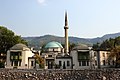
The Sunni Imperial Mosque


politics


Sarajevo Definitions of Sarajevo
The former area of the city of Sarajevo lies on both sides of the inner-Bosnian entity border between the Federation of Bosnia and Herzegovina and the Republika Srpska . While the largest part of the built-up area - the old town ( Stari grad ) and the new town ( Novi grad ) - is located on the territory of the Federation, some of the suburbs in the south that are being developed are part of the Republika Srpska.
In the Federation, the city of Sarajevo is divided into four municipalities. These are Stari Grad ( old town , 7), Centar ( center , 1), Novi Grad ( new town , 5) and Novo Sarajevo ( New Sarajevo , 6). The communities Vogošća and Ilidža do not belong to the actual city, neither historically nor structurally.
The part of Sarajevo belonging to the Republika Srpska is known as Istočno Sarajevo ( East Sarajevo ). It is divided into seven municipalities, of which only Istočno Novo Sarajevo can be described as belonging to the actual urban area. The remaining six communities are predominantly rural and separated from the city of Sarajevo by mountain ranges and / or forests. Nevertheless, Istočno Sarajevo has the status of a city.
City administration
The city of Sarajevo in the Federation is an administrative unit made up of four municipalities, each with its own administration. The head of the city administration is the mayor, since February 2017 Abdulah Skaka (* 1983). His predecessors in office were Ivo Komšić (2013–2017), Alija Behmen (2009–2013), Semiha Borovac (2005–2009) and Muhidin Hamamdžić (2000–2005). A city council ( Gradsko vijeće ) with 28 deputies acts as the legislature , whose voting proportions are based on the election results in all four municipalities.
Twin cities
Sarajevo maintains international city partnerships with the following cities:
|
|
Economy and Infrastructure

The Bosnian War largely brought the economy in Sarajevo to a standstill. However, it is gradually recovering at the same time as the entire market in the country.
Before 1992, Sarajevo was the commercial and industrial center of Bosnia and Herzegovina. In the post-war period there were almost no active industrial complexes in the city. The Volkswagen Sarajevo automobile factory , which produces VW vehicles for the Southeast European market , is located in Sarajevo . The city is also the seat of the automotive supplier Prevent .
The city is the seat of the central bank of Bosnia and Herzegovina, founded in 1997, and the country's largest stock exchange. The largest resident companies include BH Telecom , Bosnalijek , Energopetrol , Fabrika Duhana Sarajevo tobacco factory and Sarajevska pivara brewery .
traffic
Road traffic


Sarajevo is the center of road traffic in Bosnia and Herzegovina. Seven major main roads connect the capital with the other parts of the country. The M5 (towards Travnik , Banja Luka , Bihać ), the M17 (towards Zenica and Doboj ) and the M18 (towards Tuzla ) lead to the north . The M5 (to Višegrad and Goražde ) and the M19 (to Zvornik ) run to the east . In the south, the M18 leads via Foča to Dubrovnik or Montenegro . The M17 leads to the west (towards Mostar ).
Since 2003, Sarajevo has had its own motorway connection to the A1 , which connects the city with Visoko and Zenica . An expansion to the north towards Budapest and south towards Mostar is being planned. An urban motorway is also under construction, which will connect the districts of Ciglane and Pofalići over a distance of 2.6 km. Even before the Olympic Games, two tunnels (700 m) were built for this, but the rest of the motorway was put on hold due to financial problems. Only one tunnel is used today.
Public transport

In 1882, with the opening of the Bosnabahn, the city was connected to the railway network. The Narentabahn , which was also narrow - gauge, followed in 1891 . Today there are daily connections on the Sarajevo – Šamac railway to Zenica , Doboj and Bihać and the Sarajevo – Ploče railway over the Ivan Pass to Mostar . The connection with the Croatian port city of Ploče was discontinued with the 2013/14 timetable change. The trains via Mostar now end in the Bosnian Čapljina . The connection to Budapest was resumed in spring 2002, but has since been discontinued. Until the 1970s there was also a connection to Belgrade via the Bosnian Eastern Railway , the former route of which is now partially used for the southern bypass of the city center (Put Mladih Muslimana) .
The city can be reached via a well-developed network of bus connections. Buses from Belgrade go almost exclusively to the Serbian part of the city, Istočno Sarajevo.

As public transportation that exist in the city tram Sarajevo (since 1885) with seven lines, the trolley bus Sarajevo with five lines and several bus and - Minibus - lines . Local public transport is operated by the transport company JKP GRAS Sarajevo . Before the Bosnian War, a metro was planned, but never built.
A cable car (Trebevićka žičara) leads from the district of Bistrik to the slopes of the local mountain Trebević.
Airport

Sarajevo International Airport is located in the Dobrinja district . It has a 2,600 m long runway and was opened on June 2, 1969.
There are regular connections to Berlin , Zurich , Munich , Vienna , Düsseldorf , Cologne , Copenhagen , Ljubljana , Zagreb , Budapest , Istanbul and Belgrade .
During the Bosnian War, the airport was occupied by Bosnian Serbs on the night of April 4th and 5th, 1992. In June 1992 the airport was taken over by UNPROFOR . It was badly damaged in the 1992-1995 war. It was reopened to civil traffic on August 16, 1996. In 2001 the airport was completely renovated and in June 2005 received the award “Best European Airport” from the Airport Council International in the category: Airport with less than 1,000,000 passengers.
From June 1992 to 1996 the airport was only used by military aircraft. Humanitarian aid for Sarajevo, foreign journalists, artists, politicians, negotiators, diplomats and residents with UN, press or UNHCR ID cards were processed here. The airport operation depended very much on the political goals and military activities of the besiegers. In truth, it was not the French blue helmets that controlled the airport, but the besiegers. Before the completion of the Sarajevo tunnel in 1993, the residents could only leave and reach the besieged city via the runway. The airport was secured by barbed wire, trenches and other UNPROFOR obstacles. The fleeing residents had to escape not only the snipers, but also the white UN transport and patrol vehicles that wanted to prevent them from crossing the runway. The number of fatalities and injuries on the runway was announced daily on the radio. Several times during the siege , UNPROFOR organized transports for civilians across the runway.
education

In Sarajevo there are 46 primary schools (grades 1–8) and 33 high schools (grades 9–13).
The University of Sarajevo has existed since the 1940s. There are also various other universities. The city is home to around 40,000 students. The National Library, which was badly damaged in the Bosnian War, previously housed one of the most important literary collections in Eastern Europe.
Culture and sights


There are numerous theaters , museums and cultural institutions in Sarajevo , whereby the most famous and most important museum, the National Museum of Bosnia and Herzegovina (Bosnian: Zemaljski Muzej Bosne i Hercegovine) was closed since October 2012 for financial, but also for political reasons. September 2015 opened again.

Various important cultural events take place in the city every year: the Sarajevo Film Festival , the Jazz Festival, “Baščaršijske noći”, the “MESS” cultural festival and “Sarajevska Zima” (Sarajevo Winter).
Sarajevo has a beautiful, oriental-style old town with several mosques and churches, Baščaršija Square ( bazaar ) and numerous shops. The old town was renovated after the war.
Museums
- National Museum of Bosnia and Herzegovina
- Sarajevo Museum
- Historical Museum of Bosnia and Herzegovina
- War Childhood Museum
- Museum of Crimes against Humanity and Genocide (Muzej Zločina protiv čovječnosti i genocida)
Buildings

Sacred buildings
- Gazi Husrev Beg Mosque , built 1530–1531 by builder Adzem Esija Ali
- Ali Pasha Mosque , built in 1560/1561
- Imperial Mosque , 1566
- Old Orthodox Church, 16th century
- Roman Catholic Cathedral , 1889
- Orthodox Cathedral , 1882
- Jewish cemetery , since 1630
Other structures
- Academy of Fine Arts (formerly Protestant Church), 19th century
- University building, 19th century
- Despića kuća (Despića house, traditional house of a Serbian merchant family, now a museum)
- Latin Bridge (formerly Princip Bridge)
- Goat Bridge east of the old town

- Vijećnica , built in the 19th century as the town hall of Sarajevo, used as the national and university library since 1948, badly damaged in the war in 1992, a detailed reconstruction took place from 1996 to 2014
- National Museum , 19th century
- Historical Museum of Bosnia and Herzegovina , built in 1963 by Boris Magaš
- Markale City Market Hall , 19th century
- Brusa bezistan, built in 1551 as a market hall for clothing, now houses an exhibition of the Sarajevo City Museum
- Sebilj , oriental fountain in the old town
- Olympic Hall Juan Antonio Samaranch (Olympic Hall Zetra)
- Hotel Holiday (formerly Holiday Inn), built in 1983 by Ivan Štraus


- Sarajevo City Center, built in 2014, large shopping center opposite the Parliament building
- UNIS towers, built in 1986 by Ivan Štraus
- Bosmal City Center , was until 2008 the tallest skyscraper in the Balkans with a height of 118 meters
- Avaz Business Center
- Avaz Twist Tower , at 172 meters the tallest building in the Balkans
- Parrot House (Papagajka) , built from 1988-1990 by Dragan Bijedić and Mladen Gvozden
Sports centers
- Otoka Stadium
- Stadium Koševo (home stadium of FK Sarajevo)
- Skenderija , 1969
music
Sarajevo was considered an important center of Yugoslav rock music. From the city came u. a. the nationwide popular bands Indexi (since the 1960s), Bijelo dugme (around band leader Goran Bregović from 1974), Divlje Jagode and Zabranjeno pušenje (with Emir Kusturica , among others ), Crvena Jabuka , Plavi orkestar and Hari Mata Hari in the 1980s. Then there were the hard rock and heavy metal band Vatreni Poljubac ( German: Feuriger Kuss ) and the folk rock group Nervozni poštar ( nervous postman ).
Well-known pop-rock singers are Jadranka Stojaković and Jasna Gospić , as well as Ismeta Dervoz-Krvavac , who also worked regularly for television.
Sports
The 1984 Winter Olympics were held in Sarajevo . Several buildings erected in this context can be visited in the city and the surrounding area, some of them in a ruinous state, such as the Juan Antonio Samaranch Olympic Hall , the bobsleigh and toboggan run on Trebević , the Olympic ski jumps on Igman and other facilities in the mountains Jahorina and Bjelašnica. Sarajevo had applied for the 2010 Winter Olympics, but was not considered as a candidate city.
In September 2001 Sarajevo was the venue for the 17th European Junior Championships in amateur boxing ; In July 2016, the U18 women’s European basketball championship took place in the city.
From February 10-15, 2019, Sarajevo and Istočno Sarajevo jointly hosted the European Youth Olympic Festival , which took place in the city and on the surrounding mountains.
There are several football clubs in the city. The most popular are the FK Sarajevo and the FK Željezničar Sarajevo . There is also the second division club FK Olimpic Sarajevo .
The basketball club Košarkaški Klub Bosna Sarajevo won the 1979 European Cup.
Sarajevo in art
literature
- Semezdin Mehmedinović : Sarajevo Blues. 1992.
- Miljenko Jergović : Sarajevo Marlboro (Sarajevski Marlboro). 1994.
- Dževad Karahasan : Sara and Serafina (Sara i Serafina). 1999.
Movie
Since the 1990s in particular, Sarajevo has been the setting and / or location of several internationally acclaimed feature films, which mainly dealt with the Bosnian war and its consequences. Films made in Sarajevo before 1991 achieved notoriety, with a few exceptions, only within Yugoslavia.
Selection of films:
- Valter brani Sarajevo (1972; Director: Hajrudin Krvavac )
- Do you remember Dolly Bell? ( Sjećaš li se Doli Bel?; 1981; Emir Kusturica )
- Dad is on a business trip ( Otac na službenom putu ; 1985; Emir Kusturica )
- Welcome to Sarajevo (1997; Michael Winterbottom )
- Golden Valley Sarajevo ( Ljeto u zlatnoj dolini ; 2003; Srđan Vuletić )
- Esma's secret - Grbavica ( Grbavica ; 2006; Jasmila Žbanić )
- Paradise between us ( Na putu ; 2010; Jasmila Žbanić )
- In the Land of Blood and Honey (2011; Angelina Jolie )
- Twice Born ( venuto al mondo ; 2013; director: Sergio Castellitto leading actress: Penélope Cruz Sánchez )
Personalities
literature
- Erich Rathfelder : intersection Sarajevo. Bosnia and Herzegovina ten years after Dayton: Muslims, Orthodox, Catholics and Jews are building a common state. Schiler, Berlin 2006, ISBN 3-89930-108-0 .
- Marko Plesnik: Sarajevo. With Ilidža, Butmir, Rakitnica Gorge and the winter sports areas . Trescher, Berlin 2013, 1st edition, ISBN 978-3-89794-246-2 .
- Robert J. Donia: Sarajevo. A biography. Hurst, London 2006, ISBN 1-85065-765-3 (English).
- Emily Greble: Sarajevo 1941-1945. Muslims, Christians, and Jews in Hitler's Europe. Cornell University Press, Ithaca, NY 2011, ISBN 978-0-8014-4921-5 (English).
- Holm Sundhaussen : Sarajevo. The history of a city , Böhlau, Cologne 2014, ISBN 978-3-205-79517-9 .
Web links
- Website of the city of Sarajevo (Bosnian / Croatian / Serbian, English)
- Sarajevo city guide with a presentation of the history of the city
- Sarajevo Panorama Virtual Tour 360 ° (Bosnian, English)
- Sarajevo 1984-2004: 20 years after the Olympic Games (pictures including panoramic shots)
- Documentation of a report trip by young journalists to Sarajevo
- Another list of contemporary buildings in Sarajevo
Individual evidence
- ↑ a b c Preliminary Results Of the 2013 Census of Population, Households and Dwellings in Bosnia and Herzegovina (PDF; 752 kB; English / Bosnian). Agency for Statistics of Bosnia and Herzegovina, November 5, 2013. Accessed December 9, 2013.
- ↑ Vatrometom završeno obilježavanje dana grada Sarajeva (Bosnian)
- ↑ Archived copy ( memento of the original from September 6, 2018 in the Internet Archive ) Info: The archive link was inserted automatically and has not yet been checked. Please check the original and archive link according to the instructions and then remove this notice.
- ↑ Constitution in the original text
- ↑ Temperatures And Precipitations ( Memento of the original from September 24, 2015 in the Internet Archive ) Info: The archive link was inserted automatically and has not yet been checked. Please check the original and archive link according to the instructions and then remove this notice.
- ↑ Gerhard Herm : The Balkans. The powder keg of Europe. Econ Verlag GmbH, Düsseldorf / Vienna / New York / Moscow 1993, p. 193, ISBN 978-3-430-14445-2 .
- ↑ United States Commission for the Preservation of America's Heritage Abroad: Jewish Heritage Sites of Bosnia-Herzegovina - “Luburica Villa” - Ustashe Prison and Execution Place . 2011, p. 20.
- ↑ Human Rights Watch Report on Abuse at Viktor Bubanj Barracks, 10/1994
- ^ Results of the 1991 census for the four municipalities of Stari Grad, Centar, Novi Grad and Novo Sarajevo
- ↑ Agencija za statistiku Bosne i Hercegovine: Popis stanovništva, domaćinstava i stanova u Bosni i Hercegovini, 2013. Rezultati popisa. (pdf, 19.7 MB) Sarajevo, June 2016; P. 56ff
- ↑ Primary Education & Secondary Education data of the canton Sarajevo (PDF document)
- ↑ The Parrot Building. Retrieved May 16, 2018 .
- ↑ Full Schedule of the 2016 FIBA U18 Women's European Championship Division B - FIBA.com. In: FIBA.com. Retrieved July 22, 2016 .