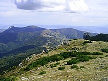
Jahorina

The Jahorina ( Serbian - Cyrillic Јахорина ) is a mountain range in the east of Bosnia and Herzegovina . It stretches from Trebević on the southern outskirts of Sarajevo over 30 kilometers to the Prača valley cut northwest of Goražde . The Jahorina is part of the Dinaric mountain system . Its highest point is the Sjeništa at 1913 m. i. J.
The western part of the mountain is protected as the Jahorina National Park.
geography
The Jahorina mountain range is bounded in the northwest by Sarajevo polje and the Miljacka river . At the Vitez Pass east of Pale the mountains merge into the Romanija . The boundary to the north and east is the Prača gorge ; to the south are the Drina and Bistrica valleys . In the west, the Jahorina is separated from the Bjelašnica massif by the Željeznica valley .
history
The western foothills of the Jahorina formed strategically important attack positions for the artillery of the troops of the Republika Srpska during the siege of Sarajevo during the Bosnian War . The mountains were fiercely contested for almost all of the war; Large areas are still mined today .
The border between the entities Republika Srpska and Federation of Bosnia and Herzegovina runs across the mountains.
traffic
All major transport connections bypass the Jahorina Mountains in the north or south. Thus, the use of main road 5 (Sarajevo- Višegrad ) as well as the route of the former Bosnian Eastern Railway to Belgrade the valleys of Miljacka Praca, while the trunk road M18 (Sarajevo- Foča - Nikšić ) runs through the southern valleys of the Željeznica and Bistrica.
Winter sports
The second Winter Universiade took place here in 1955 . During the 1984 Winter Olympics in Sarajevo, the Jahorina was used as a venue for the women's alpine skiing competition . In advance, a modest tourism infrastructure was built in the mountains, which can currently only be used to a limited extent due to the precarious mine situation. However, many ski slopes have been reopened in recent years. The Jahorina is relatively snow-sure in winter, there is usually more than a meter of snow in the summit locations.
Individual evidence
- ↑ Universiade 2011 Shenzhen, Statistics and Dates ( Memento of the original from August 8, 2010 in the Internet Archive ) Info: The archive link was inserted automatically and has not yet been checked. Please check the original and archive link according to the instructions and then remove this notice. ; As of August 4, 2009.
Web links
Coordinates: 43 ° 42 ′ 0 ″ N , 18 ° 39 ′ 0 ″ E


