M5 (Bosnia and Herzegovina)
| Magistralna cesta / Magistralni put M5 in BiH | ||||||||||||||||||||||||||||||||||||||||||||||||||||||||||||||||||||||||||||||||||||||||||||||||||||||||||||||||||||||||||||||||||||||||||||||

|
||||||||||||||||||||||||||||||||||||||||||||||||||||||||||||||||||||||||||||||||||||||||||||||||||||||||||||||||||||||||||||||||||||||||||||||
| |
||||||||||||||||||||||||||||||||||||||||||||||||||||||||||||||||||||||||||||||||||||||||||||||||||||||||||||||||||||||||||||||||||||||||||||||
| map | ||||||||||||||||||||||||||||||||||||||||||||||||||||||||||||||||||||||||||||||||||||||||||||||||||||||||||||||||||||||||||||||||||||||||||||||
| Basic data | ||||||||||||||||||||||||||||||||||||||||||||||||||||||||||||||||||||||||||||||||||||||||||||||||||||||||||||||||||||||||||||||||||||||||||||||
| Operator: | ||||||||||||||||||||||||||||||||||||||||||||||||||||||||||||||||||||||||||||||||||||||||||||||||||||||||||||||||||||||||||||||||||||||||||||||
| Overall length: | 505 km | |||||||||||||||||||||||||||||||||||||||||||||||||||||||||||||||||||||||||||||||||||||||||||||||||||||||||||||||||||||||||||||||||||||||||||||
| Departure to Bihać from the direction of Bosanski Petrovac | ||||||||||||||||||||||||||||||||||||||||||||||||||||||||||||||||||||||||||||||||||||||||||||||||||||||||||||||||||||||||||||||||||||||||||||||
|
Course of the road
|
||||||||||||||||||||||||||||||||||||||||||||||||||||||||||||||||||||||||||||||||||||||||||||||||||||||||||||||||||||||||||||||||||||||||||||||
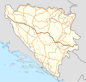
The M5 ( Bosnian / Croatian Magistralna cesta or Serbian Магистрални пут / Magistralni put ) is a main road in Bosnia and Herzegovina . It leads from the Croatian border near Bihać through the cantons / regions Una-Sana , Banja Luka , Central Bosnia , Zenica-Doboj , Sarajevo , Sarajevo-Romanija , Bosnian Podrinje and Foča . It is part of the European route E 761 Bihać - Zaječar .
course
The M5 begins at the Izačić border crossing to Croatia, where it connects to the D217 or D1 to Karlovac . The first larger city is Bihać , where the M5 runs directly past the old town and crosses the Una . In the eastern part of the city, the M4-2 branches off to Velika Kladuša . The M5 now turns south in order to approach the 790 m high Brusovac Pass behind Dubovsko - first in the Una valley, then on a serpentine route . After crossing it, the road descends to Bosanski Petrovac . There the M14-2 coming from Drvar joins from the right .
Over two 797 and 717 m high passes (Grla and Lanište) and through the Bravsko polje , the main road reaches the valley of the Sana near Ključ , where it meets the M15 coming from Prijedor . Behind the city begins the Republika Srpska , up to this point the M5 runs on the territory of the Federation of Bosnia and Herzegovina . A serpentine route leads over the foothills of the Dimitor to Mrkonjić Grad . Before Jajce the section ends in the Republika Srpska and the M5 passes the Pliva Lakes.
In Jajce the road crosses the Vrbas , turns right and now runs on a common route with the M16 through its gorge to the south, while the left branch of the M16 leads to Banja Luka . In Donji Vakuf the two roads separate again and the M5 leads north-east over the 927 m high Komar Pass into the Lašva valley and to Travnik ; the M16 continues towards Bugojno . Behind Travnik leaving the road the Lašvatal, during which she is very busy and performs on Busovača and Kiseljak and the 625 m high pass Kobiljača after Ilidža and Sarajevo .
Within the Bosnian capital, Magistralstrasse 5 runs on the inner-city one-way street ring, forming the Sniper Alley to the east, which was notorious during the Bosnian War . The road leaves Sarajevo through several tunnels and reaches the Republika Srpska and the city of Pale again over inclines of 10% .
Between Pale and Višegrad , the M5 now mainly uses the old route of the Bosnian Eastern Railway . In the Prača valley, which is used as a transport corridor, it crosses around 40 single-lane railway tunnels alone, which are up to 900 m long and unlit. This route has not yet been expanded on the unpaved 20 kilometers between Prača and the connection to the M19-3 south of Rogatica , although the M5 is consistently marked as a trunk road on some current road maps.
When you reach the M19-3 from Rogatica, the route is paved again and the tunnels are illuminated and have two lanes. In Ustiprača the M20 branches off towards Foča and Trebinje ; the M5 turns to the north and is now well developed to Višegrad on the left bank of the dammed Drina . Below the Ottoman Drina Bridge , it crosses the river via a new road bridge. The main road through the Rzav valley reaches the Serbian border station Kotroman 20 km after Višegrad .


