
Canton of Una-Sana
| Canton of Una-Sana | |
|---|---|

|
|
| Residents | 299,343 pop (2013) |
| Population density | 72.6 inhabitants / km² |
| surface | 4125 km² |
| Administrative headquarters |
Bihać
|
| Head of government | Mustafa Ružnić |
| Communities | 8th |
| ISO-3166-2 code |
BA-BIH
|
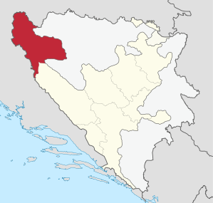  Location of the canton in Bosnia and Herzegovina |
|
The canton of Una-Sana ( Bosn. Unsko-Sanski canton , Croat . Unsko-sanska županija , often also abbreviated as USK ) is one of the ten cantons in the Federation of Bosnia and Herzegovina . It is located in the northwest of the country and has its administrative headquarters in Bihać .
The canton has an area of 4,125 km².
geography

The canton borders the Croatian Sisak-Moslavina County in the north, the Republika Srpska in the east and southeast , Canton 10 in the south , and the Zadar and Lika-Senj counties in the west . Historically, it includes the western part of the so-called Bosanska Krajina ( Bosnian border region ). Numerous castle ruins remind of the important strategic location of the area.
The two largest rivers are Una and Sana , which give the canton its name. The smaller bodies of water include the Sanica in the east and the Glina , which marks the border with Croatia in the north .


The canton of Una-Sana is topographically divided into four. The north-west is dominated by the forested low mountain ranges of the Banija , which rise up to 630 m on the Croatian border near Bužim . In the east and south, the mostly gorge-like valley of the Una connects. The main town of the canton, Bihać, is located in its most extensive plain . Again to the south-east is the impassable and sparsely populated Grmeč Mountains, the highest point of which is the Crni Vrh (“Black Peak”) at 1604 m . The easternmost part of the canton is formed by the Sana valley with the towns of Sanski Most and Ključ .
West of Bihać - on the Croatian border - part of the Plješevica Mountains is part of the Una-Sana canton. Its 1649 m peak is also the highest point in the canton. South of Bihać, a narrow, approximately 30 km long strip of territory with the towns of Kulen Vakuf and Martin Brod belongs to the canton. Here is the Una National Park with numerous waterfalls.
population
The canton had around 299,000 inhabitants in 2013. It is one of the federation's five mostly Bosniak cantons.
Municipalities in the canton of Una-Sana
- Cazin (69,411 inhabitants)
- Bihać (61,186 inhabitants)
- Velika Kladuša (44,770 inhabitants)
- Sanski Most (47,359 inhabitants)
- Bosanska Krupa (29,659 inhabitants)
- Ključ (18,741 inhabitants)
- Bužim (20,298 inhabitants)
- Bosanski Petrovac (7,946 inhabitants)
traffic
The main traffic routes are main roads 4-2, 5 , 14 and 15 . The M4-2 begins on Bosnian territory at the Maljevac border crossing and leads via Velika Kladuša and Cazin , before joining the M14 coming from the east at Ostrožac . It is the busiest connection between Croatia and Bihać.
The M5 begins at the Izačić border crossing and leads to Ključ via Bihać and Bosanski Petrovac . From there it continues towards Jajce and Sarajevo . So it connects the western with the eastern part of the canton. The M14 runs through the Una Gorge and connects Bosanska Krupa with Bihać, while the M15 runs through the Sana Valley and connects Ključ with Sanski Most .
With the Una-Bahn a railway line - coming from Knin - runs in the valley of the Una and has stations u. a. in Martin Brod , Kulen Vakuf , Bihać , Bosanska Krupa and Bosanska Otoka . However, since the Bosnian War , it has only been served by passenger trains temporarily and only on the section from Bihać to Novi Grad .
Web links
Individual evidence
- ^ Federacija Bosne i Hercegovine. Federalni zavod za statistiku: Federacija Bosne i Hercegovine u brojkama , Sarajevo 2008 ( Memento of the original from September 8, 2008 in the Internet Archive ) Info: The archive link was inserted automatically and has not yet been checked. Please check the original and archive link according to the instructions and then remove this notice. (PDF; 278 kB), p. 11.
- ↑ Preliminary results of the 2013 census (PDF; 752 kB)
- ↑ The population figures are based on the official estimate for June 30, 2007 ( PDF ( Memento of the original from September 27, 2007 in the Internet Archive ) Info: The archive link has been inserted automatically and has not yet been checked. Please check the original and archive link according to instructions and removed then this note. )
_-_colored.svg)
Coordinates: 44 ° 44 ' N , 16 ° 12' E