
Canton 10
| Canton 10 | |
|---|---|
| Residents | 84,127 pop (2013) |
| Population density | 17 inhabitants / km² |
| surface | 4,934.1 km² |
| Administrative headquarters | Livno |
| Communities | 6th |
| ISO-3166-2 code |
BA-10
|
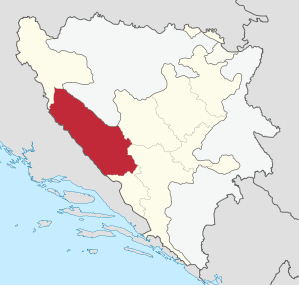  Location of the canton in Bosnia and Herzegovina |
|
The Canton 10 (also Canton Livno / Livanjski canton / Hercegbosanska županija / Zapadnobosanski CANTON called; alternatively Herceg-Bosna or western Bosnia ) is one of the ten cantons of the Federation of Bosnia and Herzegovina , one of the two entities of the State of Bosnia and Herzegovina .
The name of the canton has long been controversial between the representatives of the Croatian and Bosniak ethnic groups. In official documents it is therefore usually referred to as canton 10 after the serial number . The canton has an area of 4,934.9 km², but only about 84,000 inhabitants, making it the largest in area and the least populated canton in the Federation. The administrative seat is in Livno .
Expansion and History
The canton extends over the southwestern part of Bosnia . The area around Livno, Tomislavgrad and Kupres did not belong to the then Sanjak Herzegovina during the Ottoman period , but first to the Sanjak Klis (in Dalmatia) and then, after this became largely Venetian , to Bosnia. It was called Završje . Its cities, especially Livno, had a Bosnian-influenced urban cityscape.
population
The canton had around 84,000 inhabitants in 2013 and is very sparsely populated with fewer than 20 inhabitants per square kilometer. It is one of the three cantons of the Federation of Bosnia-Herzegovina with a predominantly Croatian population: Almost 77% of the population stated in the 2013 census that they were Croatians .
Communities
.png)
The canton comprises the following six municipalities (2013 population figures):
- Bosansko Grahovo (2,449)
- Drvar (7,036)
- Glamoc (3,860)
- Kupres (5,057)
- Livno (34,133)
- Tomislavgrad (31,592)
Web links
- Government of the canton
- Statistical information on Canton 10 on the website of the Statistical Office of the Federation of Bosnia and Herzegovina
Individual evidence
- ^ Federacija Bosne i Hercegovine. Federalni zavod za statistiku: Federacija Bosne i Hercegovine u brojkama , Sarajevo 2008 ( Memento of the original from September 8, 2008 in the Internet Archive ) Info: The archive link was inserted automatically and has not yet been checked. Please check the original and archive link according to the instructions and then remove this notice. (PDF; 278 kB), p. 11.
- ↑ a b Agencija za statistiku of Bosnia and Herzegovina: Description stanovništva, domaćinstava stanova i u i Bosni Hercegovini, 2013. Rezultati popisa. (pdf, 19.7 MB) Sarajevo, June 2016; P. 55
_-_colored.svg)
Coordinates: 43 ° 50 ' N , 17 ° 0' E