Kulen Vacuf
|
Kulen Vakuf Кулен Вакуф |
||
|
|
||
| Basic data | ||
|---|---|---|
| State : | Bosnia and Herzegovina | |
| Entity : | Federation of BiH | |
| Canton : | Una-sana | |
| Municipality : | Bihać | |
| Coordinates : | 44 ° 34 ' N , 16 ° 5' E | |
| Height : | 340 m. i. J. | |
| Residents : | 487 (2013) | |


Kulen Vakuf (previously also Novoselo ) is a place in Bosnia and Herzegovina belonging to the Bihać community . It is located in the north-west of the country in the Una-Sana canton of the Federation of Bosnia and Herzegovina , near the Croatian border.
The name part Vakuf comes from the Arabic Waqf . These were foundations financed by private individuals. The original meaning of the word kulen is unclear.
geography
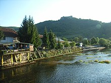
The place is about 3 km from the border in a small basin belonging to the Una valley . The mountains surrounding the place rise up to more than 1100 m on both sides. Most of the village (including the center) is on the left bank, i.e. south of the river. Kulen Vakuf is located about 40 km southeast of Bihać and 20 km west of Bosanski Petrovac .
history
The area around Kulen Vakuf was already settled in the Bronze Age . This is proven by grave finds from this time. In Roman times the place was called Cleuna . Due to its location on the military border and at the crossing over the Una, Kulen Vakuf was of great strategic importance at the time of the Ottoman rule over Bosnia. On May 19, 1835, there was a battle between Ottoman and Austrian troops. In 1878 the place burned down several times during the fighting for the occupation of the country by Austria-Hungary . In September 1941 there was a massacre of native Muslims by Chetnik units in Kulen Vakuf in revenge for acts of violence committed by the Ustasha . Over 1000 people were murdered.
Bosnian War
On October 29, 1994, Bosniak forces under General Dudaković advanced to Kulen Vakuf. But the Serbs were able to recapture the town on November 6th. During the Serbian occupation, the place was called Srbobran to avoid the original Turkish name. In the last major ARBiH operation , Kulen Vakuf was retaken on September 14, 1995. With the Dayton Treaty , the Federation of Bosnia and Herzegovina came into being.
Culture and sights
The castle ruin Ostrovica (from Slav. Ostr for "sharp" or "pointed") towers over the place and represents one of the largest fortifications in the region. The terraces of the houses on the banks on stilts above the Una are characteristic of the place itself. Something similar can also be found in Bihać and Bosanska Krupa . The mosque is located in the center of the village.
population
In the 1991 census, 770 of 1063 inhabitants (72.4%) identified themselves as Bosniaks , 182 (17.1%) as Serbs , 99 (9.3%) as Yugoslavs and 12 (1.1%) as members of other ethnic groups . At the 2013 census, Kulen Vakuf only had 487 inhabitants.
economy
Kulen Vakuf is the modest tourist center on the upper Una. The majority of local and international guests who come to the region for water sports or fly fishing stay here.
traffic
An asphalt road leads north via Orašac to Magistral Road 5 to Bihać . An unpaved, but easily passable gravel road runs to the 10 km south of Martin Brod at the entrance of the Unac gorge.
The place has a train station on the Una-Bahn , which is currently not served by passenger trains (as of 2016).
swell
- ↑ Peter König: Late Bronze Age hoards from Bosnia and Herzegovina , Franz Steiner Verlag 2004.
- ^ LW Seider-Sohn: Occupation of Bosnia and Hercegovina by Kk troops in 1878 , 1879.
- ^ Steven L. Burg, Paul S. Shoup: The War in Bosnia-Herzegovina: Ethnic Conflict and International Intervention , ME Sharpe 1999.
- ↑ Results of the 2013 census on statistika.ba


