Vrbas (river)
|
Vrbas Врбас |
||
| Data | ||
| location | Bosnia and Herzegovina | |
| River system | Danube | |
| Drain over | Save → Danube → Black Sea | |
| source | Vranica | |
| Source height | 1780 m | |
| muzzle |
Save coordinates: 45 ° 6 ′ 28 " N , 17 ° 30 ′ 49" E 45 ° 6 ′ 28 " N , 17 ° 30 ′ 49" E |
|
| Mouth height | 93 m | |
| Height difference | 1687 m | |
| Bottom slope | 7.2 ‰ | |
| length | 235 km | |
| Catchment area | 5023 km² | |
| Drain |
MQ |
102 m³ / s |
| Left tributaries | Pliva | |
| Right tributaries | Ugar , Vrbanja | |
| Big cities | Bugojno , Donji Vakuf , Jajce , Banja Luka | |
| Navigable | not navigable | |
|
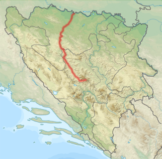
Course of the Vrbas highlighted in red |
||
|
The Vrbas river at the Bočac hydroelectric power station |
||
|
The Vrbas in Krupa |
||
The Vrbas ( Serbian - Cyrillic Врбас ; from Serbo-Croatian vrba for "pasture") is a right tributary of the Save in the west of Bosnia and Herzegovina . It rises in the Vranica Mountains , about 20 kilometers east of Gornji Vakuf-Uskoplje , and flows into the Save near Srbac . The Vrbas is about 235 kilometers long from the source to the confluence with the Save.
Important tributaries of the Vrbas are the Pliva , which flows into the Vrbas from the left with a waterfall at Jajce , the Ugar , which flows into the Vrbas a good 10 kilometers below Jajce, and the Vrbanja , which comes from the Vlašić at Banja Luka in the Vrbas empties. Larger towns on the Vrbas are Gornji Vakuf-Uskoplje , Bugojno , Donji Vakuf , Jajce and Banja Luka.
Between Jajce and Banja Luka, the Bočac hydropower plant (Hidroelektrana Bočac) dams the Vrbas with a 66 meter high wall to form a reservoir (Jezero Bočac) over 20 kilometers long. The power plant has been in operation since 1982 and has an output of 110 MW.
The Vrbas with its rapids is suitable for rafting . The world and European championships in rafting have already been held several times on the Vrbas.
Hydrology
With an average discharge rate of 102 m³ / s at the mouth, the Vrbas ranks sixth among the largest rivers in the country.


