Vlašić (mountains)
| Vlašić | ||
|---|---|---|
|
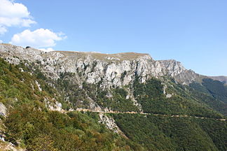
The southern flank of the Vlašić above Paklarevo |
||
| Highest peak | Paljenik ( 1943 m. I. J. ) | |
| location | Bosnia and Herzegovina | |
| part of | Dinarides | |
|
|
||
| Coordinates | 44 ° 18 ′ N , 17 ° 38 ′ E | |
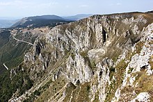
The Vlašić ( Serbian - Cyrillic Влашић ) is the northernmost of the high mountain ranges in the center of Bosnia and Herzegovina . The highest peak is the Paljenik ( 1943 m ). The mountain range is located near Travnik and flanks the north side of the Lašva valley with its distinctive cliffs, especially the Devečanske stijene.
The name of the mountain comes from the Vlachen ( vlasi ), semi-nomadic cattle breeders who used the higher elevations of the Dinarides as pasture in the summers .
geography
The Vlašić massif is located north of the town of Travnik on the territory of the municipality of the same name. It is bounded in the south by the Lašva valley, which is about 1,400 meters below, and overlooks the localities of Turbe and Paklarevo . In the east the valley of the Bila forms a natural boundary, in the north that of the Ugar, which rises here . The Vlašić represents the watershed between the catchment areas of the Vrbas in the west and the Bosna in the east, both of which flow into the Save .
Due to the altitude, cold, snowy winters and cool summers prevail on the Vlašić.
On the highest peak of the Vlašić there is a radio and television mast .
Infrastructure
Most regional traffic routes bypass the mountain range, especially since the region north of the Vlašić is relatively sparsely populated. The only road that leads over the mountains is the R413a, which branches off from the M5 in Travnik , and with the help of several serpentines and a route along the steep slope up to the 1,300-meter-high winter sports resort Babanovac. From there it continues to Kneževo (Skender Vakuf) and on towards Banja Luka .
Nowadays the heights of the Vlašić are mainly used for local recreation in addition to cattle breeding and forestry in the middle areas. On the mountain plateau around the higher peaks there are numerous weekend houses and huts from various mountaineering associations. On the north-west side there is also a small winter sports area, which also includes the Vlašić Skakaonica ski jump .
Vlašić herder cheese, which is made from fresh sheep's or cow's milk, is known nationwide.
history

During the Bosnian War , the mountains were fiercely contested due to their strategically important location overlooking the Lašva Valley, but were held for most of the time by the Vojska Republike Srpske , while the nearby Travnik was in the hands of the ARBiH . Shortly before the Dayton Agreement , the mountain was conquered by the Bosniak forces in the course of the Maestral military operation , so that the inner-Bosnian border with the Republika Srpska now runs north of the Vlašić. To date, some areas have been mined, especially on the southern slopes of the mountains.
Web links
- Official tourism site (Bosnian)


