
M20 (Bosnia and Herzegovina)
| Magistralna cesta / Magistralni put M20 in BiH | |

|
|
| map | |
 |
|
| Basic data | |
| Operator: | |
| Overall length: | 240 km |
The M20 ( Croatian / Bosnian Magistralna cesta or Serbian Магистрални пут / Magistralni put ) is a main road in Bosnia and Herzegovina . It leads from Ustiprača via Goražde , Foča , Gacko and Trebinje to the Croatian border at Ivanica .
course
The main road branches off from the M5 in Ustiprača to the south and initially runs through Goražde, Ustikolina and Foča in the Drina valley, always remaining on the western side of the river. For long stretches it runs parallel to the former branch line of the Bosnian Eastern Railway . In Brod na Drini it crosses with the M18 , which leads in a north-westerly direction via Trnovo to Sarajevo or in a south-easterly direction on the other side of the Drinaufer to the Montenegrin border.
The M20 leaves the Drina valley south of Brod and crosses into the Sutjeska valley . Here she passes the monument to the Battle of the Sutjeska in Tjentište, before entering the narrow gorge of the river, which is part of the Sutjeska National Park .
A new section of the M20 near Čemerno between Foča and Gacko was opened on August 5, 2013. The project with the start of construction was carried out by the construction company Integral Inzenjering PLC based in Republika Srpska in September 2008. The new section has a length of approx. 9.5 km and is therefore approx. 6 km shorter than the current traffic route. It also saves road traffic an ascent and descent of several hundred meters in altitude. The new section consists of a. from the longest tunnel in Bosnia and Herzegovina with 2019 m, another tunnel, five smaller bridges and a 394 m long high bridge. The planned construction period was from September 2008 to June 30, 2013 and the project budget was EUR 37 million. The reason for the new building were landslides on the old route.
After the new construction section, the M20 passes the Klinje reservoir and reaches Gacko, located in the Gatačko polje plateau . Here the M6.1 branches off to Nevesinje , while the M20 crosses the plateau in a southerly direction. Via Bileća the road continues to Trebinje and finally to the Croatian border crossing at Ivanica, from where it is only ten kilometers to the city center of Dubrovnik.

The M20 between Ivanica (near the border with Croatia) and Volujac

M20 high bridge under construction near Čemerno (2010)
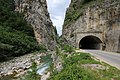
Tunnel in the Sutjeska gorge between Foča and Gacko


Individual evidence
- ↑ M20 at Wegenwiki
- ↑ Dodik open road over Čemerno saddle ( Memento of October 2, 2013 in the Internet Archive )
- ↑ Permanent solution for the landslide Čemerno at the trunk road M-20 Gacko-Foča. Archived from the original on July 24, 2013 ; accessed on May 9, 2017 .
- ↑ Archived copy ( Memento from September 23, 2015 in the Internet Archive )