Ustiprača
|
Ustiprača Устипрача |
||
|
|
||
| Basic data | ||
|---|---|---|
| State : | Bosnia and Herzegovina | |
| Entity : | Republika Srpska | |
| Coordinates : | 43 ° 41 ' N , 19 ° 5' E | |
| Height : | 320 m. i. J. | |
| Area : | 123 km² | |
| Residents : | 2,555 (2018) | |
| Population density : | 21 inhabitants per km² | |
| Telephone code : | +387 (0) 58 | |
| Structure and administration (as of 2016) | ||
| Mayor : | Mila Petković ( SNSD ) | |
| Website : | ||
Ustiprača (Cyrillic Устипрача; also Novo Goražde / Ново Горажде, from 1995 to 2002 Srpsko Goražde / Српско Горажде) is a place and seat of the association of the same name in Bosnia and Herzegovina . The municipality is located on the Prača and Drina rivers and belongs to the Republika Srpska , one of two entities of the south-east European state.
After the end of the Bosnian War , the municipality was initially referred to as Srpsko Goražde , before the Constitutional Court banned place names with ethnic attributes (according to the judgment U 44/01 of September 22, 2004 by the Constitutional Court of Bosnia and Herzegovina, as well as the previous judgment U 44 / 01 of February 27, 2004.). Since then, the name Ustiprača has mainly been in use, occasionally also Novo Goražde .
geography
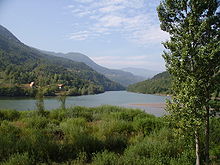
The municipality is located between the steep slopes of the east Bosnian mountains Vučevica and Jahorina ; the highest mountains in the Jahorina reach heights of more than 1400 m. The municipality seat Ustiprača is located at the mouth of the Prača river, which leaves one of the largest gorges in the country here into the dammed Drina . Goražde is about 12 km west, Višegrad 28 km northeast and Rogatica 19 km northwest.
Community structure
The municipality includes the settlements Bašabulići, Bogdanići, Borak Brdo, Borova, Bosanje, Bučje, Dragolji, Dragovići, Džuha, Đakovići, Gojčevići, Gradac, Hajradinovići, Hladila, Hrid, Hrušaniovi, Kopikiovi, Karauzlići, Kosten Krašići, Ljeskovik, Mašići, Milanovići, Nevorići, Novakovići, Odžak, Podhomara, Podkozara Gornja, Podmeljine, Pribjenovići, Prolaz, Pršeši, Radmilovići, Ropovići, Rusanj, Seoca, Surlahovi, Zaprašemi, Rusanj, Seoca ,es, Vegripjej, Vegrišemi, Rusanj, Zaprašaj, Vegripovij, Vegripovij, Vegripjej, Zakevišemi, Zakevišemi , Zidine, Zorlaci, Zubovići, Zubovići u Oglečevi, Žitovo and Živojevići as well as parts of Blagojevići, Donje Selo, Hubjeri, Podkozara Donja, Radijevići, Sopotnica, Uhotići and Žuželo.
history
The municipality of Ustiprača consists of the eastern part of the former municipality of Goražde , separated by the Dayton Treaty by the inner-Bosnian border , the greater western part of which is now part of the Federation .
population
The community had a total of 3,117 inhabitants at the 2013 census. Of these, 1618 identified themselves as Serbs (51.9%), 1459 as Bosniaks (46.8%) and two as Croats .
38 indicated different or no affiliation. At the 1991 census, the actual place Ustiprača had 498 inhabitants; 448 (90%) of them identified themselves as Bosniaks and 37 (7.4%) as Serbs. After the war, due to expulsions and flight, the place was almost exclusively inhabited by Serbs at times.
Economy and Infrastructure
Ustiprača is located at the intersection of the two main roads M5 ( Sarajevo - Višegrad ) and M20 (to Foča and Dubrovnik ), which were modernized in this section in 1989-91. The fastest connection to Sarajevo, however, is the M 19-3 that runs via Rogatica . The settlements in the higher elevations can only be reached via poor roads.
Ustiprača was a station on the Bosnian Eastern Railway , a narrow-gauge line from Sarajevo to Užice , until 1978 . A branch line to Goražde and Foča also branched off here, so that the place served as a railway junction and transfer station. The railway line was closed and most of it was dismantled.
Web links
Individual evidence
- ↑ http://rzs.rs.ba/front/article/3630/ Updated population figures for 2018 from the Institute for Statistics of the Republika Srpska. Retrieved June 9, 2019.
- ↑ Agencija za statistiku Bosne i Hercegovine: Popis stanovništva, domaćinstava i stanova u Bosni i Hercegovini, 2013. Rezultati popisa. (pdf, 19.7 MB) Sarajevo, June 2016; P. 62


