
Milići
|
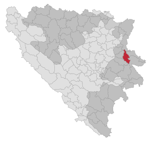
Milići Милићи |
|||
|
|
|||
|
|||
| Basic data | |||
|---|---|---|---|
| State : | Bosnia and Herzegovina | ||
| Entity : | Republika Srpska | ||
| Coordinates : | 44 ° 10 ' N , 19 ° 5' E | ||
| Height : | 273 m. i. J. | ||
| Area : | 279.13 km² | ||
| Residents : | 10,171 (2018) | ||
| Population density : | 36 inhabitants per km² | ||
| Telephone code : | +387 (0) 56 | ||
| Postal code : | 75446 | ||
| Structure and administration (as of 2016) | |||
| Mayor : | Momir Lazarević ( SNSD ) | ||
| Website : | |||
  |
|||
.svg)

Milići ( Serbian - Cyrillic Милићи ) is a place and the associated municipality (opština) in the east of Bosnia and Herzegovina . From 1962 to 1992 the municipality belonged to Vlasenica , then the municipality Milići was re-established from 5 local communities with a total of 54 settlements.
geography
The municipality is located in eastern Bosnia on Magistral Road 19 from Sarajevo via Zvornik to Belgrade at an altitude of 200 to 1500 meters. The brooks Studeni Jadar and Zeleni Jadar flow through the municipality and unite in the village to form the Jadar .
Neighboring municipalities are Bratunac and Srebrenica in the east, Rogatica and Han Pijesak in the south and Vlasenica in the west.
Boksit has been mining bauxite in the south of the municipality since 1959 .
Community structure
The municipality of Milići includes the settlements Bačići, Bešići, Bijelo Polje, Bišina, Bukovica Donja, Bukovica Gornja, Buljevići, Derventa, Donje Vrsinje, Dubačko, Dubnica, Dukići, Đile, Đurđevići, Gerovi, Glušrsje, Golijaci , Kokanovići, Koprivno, Kostrača, Krajčinovići, Lukavica, Lukići, Maćesi, Milići, Mišići, Nova Kasaba, Nurići, Pavkovići, Podbirač, Podgora, Pomol, Rajići, Raševo, Raškovići, Ristijevićičovo, Raškovići, Ristijevići , Štedra, Toljevići, Višnjica, Vitići, Vrtoče, Vukovići, Vukšići, Zabrđe, Zagrađe and Zaklopača.
history
On April 21, 1992 - two weeks after the referendum on Bosnia's independence from Yugoslavia and in the course of the JNA's move into Vlasenica - five local communities with a majority Serb population split off from the Bosniak-dominated municipality of Vlasenica and re-established the municipality of Milići, which was dissolved in 1962.
In the 1990s, a sports center and a large cultural complex were built in the center of the village. The local football club FK Boksit Milići (now FK Milići ) became champions of the first division of the Republika Srpska in 1996 and 2000 .
During the war in Bosnia , in connection with the Srebrenica massacre , there were also shootings in the municipality of Milići. After the war, mass graves were discovered especially around Nova Kasaba.
population
In contrast to the entire municipality of Vlasenica, the local community Milići had a Serbian population majority of 81% at the 1991 census. In the entire area of the newly established municipality, however, the Serbs only made up a narrow majority of 50.8%, while 47.3% of the residents described themselves as Bosniaks .
At the 2013 census, out of a total of 11,141 inhabitants, 7,180 were Serbs (62.8%) and 4,199 Bosniaks (36.9%).
traffic
Milići is connected to Sarajevo (91 km) and Zvornik (34 km) via the M19 trunk road . The first road on this route opened in 1879. There is no railway connection.
Individual evidence
- ↑ http://rzs.rs.ba/front/article/3630/ Updated population figures for 2018 from the Institute for Statistics of the Republika Srpska. Retrieved June 9, 2019.
- ↑ Agencija za statistiku Bosne i Hercegovine: Popis stanovništva, domaćinstava i stanova u Bosni i Hercegovini, 2013. Rezultati popisa. (pdf, 19.7 MB) Sarajevo, June 2016; P. 62
Web links

Banja Luka | Banovići | Berkovići | Bihać | Bijeljina | Bileća | Bos. Krupa | Bos. Brod | Bos. Petrovac | Šamac | Bos. Grahovo | Bratunac | Brčko | Breza | Bugojno | Busovača | Bužim | Cazin | Centar | Čajniče | Čapljina | Čelić | Čelinac | Čitluk | Derventa | Drvar | Doboj | Doboj Istok | Doboj Jug | Dobretići | Domaljevac-Šamac | Donji Vakuf | Donji Žabar | Foča | Foča-Ustikolina | Fojnica | Gacko | Glamoč | Goražde | Gornji Vakuf-Uskoplje | Gračanica | Gradačac | Gradiška | Grude | Hadžići | Han Pijesak | Ilidža | Ilijaš | Istočna Ilidža | Istočni Drvar | Istočni Mostar | Istočni Stari Grad | Istočno Novo Sarajevo | Jablanica | Jajce | Jezero | Kakanj | Kalesija | Kalinovik | Kiseljak | Kladanj | Ključ | Kneževo | Konjic | Kostajnica | Kotor Varoš | Kozarska Dubica | Kreševo | Krupa na Uni | Kupres | Kupres (RS) | Laktaši | Livno | Ljubinje | Ljubuški | Lopare | Lukavac | Maglaj | Milići | Modriča | Mostar | Mrkonjić degree | Neum | Nevesinje | Novi Grad | Novi Grad (Bos. Novi) | Novi Travnik | Novo Sarajevo | Odžak | Olovo | Orašje | Osmaci | Oštra Luka | Pale | Pale-Prača | Pelagićevo | Petrovac | Petrovo | Posušje | Prijedor | Prnjavor | Prozor-Rama | Ravno | Ribnik | Rogatica | Rudo | Sanski Most | Sapna | Sokolac | Srbac | Srebrenica | Srebrenik | Stari Grad | Stanari | Stolac | Šekovići | Šipovo | Široki Brijeg | Teočak | Teslić | Tešanj | Tomislavgrad | Travnik | Trebinje | Trnovo (RS) | Trnovo (FBiH) | Tuzla | Ugljevik | Usora | Ustiprača | Vareš | Velika Kladuša | Visoko | Višegrad | Vitez | Vlasenica | Vogošća | Vukosavlje | Zavidovići | Zenica | Zvornik | Žepče | Živinice