
Kupres (RS)
|
Kupres (RS) Купрес (РС) |
|||
|
|||
| Basic data | |||
|---|---|---|---|
| State : | Bosnia and Herzegovina | ||
| Entity : | Republika Srpska | ||
| Municipality : | Kupres (RS) | ||
| Coordinates : | 44 ° 5 ' N , 17 ° 9' E | ||
| Height : | 1120 m. i. J. | ||
| Area : | 89 km² | ||
| Residents : | 268 (2018) | ||
| Population density : | 3 inhabitants per km² | ||
| Structure and administration (as of 2016) | |||
| Mayor : | Gojko Šebez ( SNSD ) | ||
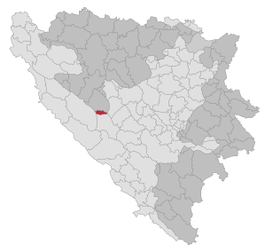 _in_BiH.svg) |
|||

Kupres (RS) ( Serbian - Cyrillic Купрес (РС) ; after the Bosnian War initially Srpski Kupres ) is one of the smallest communities in Bosnia and Herzegovina . It is located in the western part of the Republika Srpska and was created by the Dayton Agreement from three former districts of the unitary municipality Kupres , which today belongs to the Federation of Bosnia and Herzegovina . The administrative seat is Novo Selo .
geography
The places Novo Selo and Mrđanovci are located on the northern edge of the Kupresko polje at an altitude of 1100 to 1200 meters above sea level. Due to its geographical location, it can get cold there in winter as low as −30 °. However, as in all of Bosnia and Herzegovina, the summers are quite warm here, 40ºC and more are not uncommon.
population
Before the Bosnian War , Novo Selo had 320 inhabitants (including 319 Serbs ) and Mrđanovci 281 (274). Some villages in the south also had a Serb majority, but the entity boundaries were determined in 1995 by the front lines. At the 2013 census, Kupres (RS) had 300 inhabitants and was one of the poorest communities in the country. 299 of them called themselves Serbs. In addition, the average age of 53.7 years was the highest in all of Bosnia.
Infrastructure
The remote municipality is connected by a road with the neighboring municipality in the Republika Srpska, Šipovo , 30 km away , and with the small town of Kupres, 17 km away.
Individual evidence
- ↑ http://rzs.rs.ba/front/article/3630/ Updated population figures for 2018 from the Institute for Statistics of the Republika Srpska. Retrieved June 9, 2019.
- ↑ Agencija za statistiku Bosne i Hercegovine: Popis stanovništva, domaćinstava i stanova u Bosni i Hercegovini, 2013. Rezultati popisa. (pdf, 19.7 MB) Sarajevo, June 2016; P. 61
- ↑ Agencija za statistiku Bosne i Hercegovine: Popis stanovništva, domaćinstava i stanova u Bosni i Hercegovini, 2013. Rezultati popisa. (pdf, 19.7 MB) Sarajevo, June 2016; P. 41

Banja Luka | Banovići | Berkovići | Bihać | Bijeljina | Bileća | Bos. Krupa | Bos. Brod | Bos. Petrovac | Šamac | Bos. Grahovo | Bratunac | Brčko | Breza | Bugojno | Busovača | Bužim | Cazin | Centar | Čajniče | Čapljina | Čelić | Čelinac | Čitluk | Derventa | Drvar | Doboj | Doboj Istok | Doboj Jug | Dobretići | Domaljevac-Šamac | Donji Vakuf | Donji Žabar | Foča | Foča-Ustikolina | Fojnica | Gacko | Glamoč | Goražde | Gornji Vakuf-Uskoplje | Gračanica | Gradačac | Gradiška | Grude | Hadžići | Han Pijesak | Ilidža | Ilijaš | Istočna Ilidža | Istočni Drvar | Istočni Mostar | Istočni Stari Grad | Istočno Novo Sarajevo | Jablanica | Jajce | Jezero | Kakanj | Kalesija | Kalinovik | Kiseljak | Kladanj | Ključ | Kneževo | Konjic | Kostajnica | Kotor Varoš | Kozarska Dubica | Kreševo | Krupa na Uni | Kupres | Kupres (RS) | Laktaši | Livno | Ljubinje | Ljubuški | Lopare | Lukavac | Maglaj | Milići | Modriča | Mostar | Mrkonjić degree | Neum | Nevesinje | Novi Grad | Novi Grad (Bos. Novi) | Novi Travnik | Novo Sarajevo | Odžak | Olovo | Orašje | Osmaci | Oštra Luka | Pale | Pale-Prača | Pelagićevo | Petrovac | Petrovo | Posušje | Prijedor | Prnjavor | Prozor-Rama | Ravno | Ribnik | Rogatica | Rudo | Sanski Most | Sapna | Sokolac | Srbac | Srebrenica | Srebrenik | Stari Grad | Stanari | Stolac | Šekovići | Šipovo | Široki Brijeg | Teočak | Teslić | Tešanj | Tomislavgrad | Travnik | Trebinje | Trnovo (RS) | Trnovo (FBiH) | Tuzla | Ugljevik | Usora | Ustiprača | Vareš | Velika Kladuša | Visoko | Višegrad | Vitez | Vlasenica | Vogošća | Vukosavlje | Zavidovići | Zenica | Zvornik | Žepče | Živinice