
Gračanica (Doboj)
|
Gračanica Грачаница |
|||
|
|
|||
|
|||
| Basic data | |||
|---|---|---|---|
| State : | Bosnia and Herzegovina | ||
| Entity : | Federation of BiH | ||
| Coordinates : | 44 ° 42 ' N , 18 ° 19' E | ||
| Height : | 190 m. i. J. | ||
| Area : | 219.5 km² | ||
| Residents : | 45.220 | ||
| Population density : | 206 inhabitants per km² | ||
| Telephone code : | +387 (0) 35 | ||
| Postal code : | 75320 | ||
| Structure and administration (as of 2012) | |||
| Mayor : | Nusret Helić ( SDP ) | ||
| Website : | |||
  |
|||


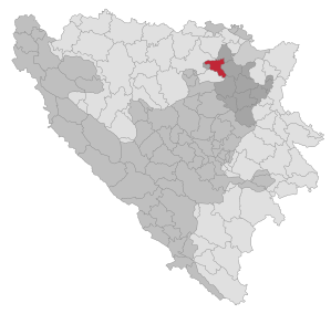
Gračanica ( Serbian - Cyrillic Грачаница ; German outdated Gratschanitz ) is a city in the northeastern part of Bosnia and Herzegovina , in the canton of Tuzla in the Federation of Bosnia and Herzegovina . The municipality covers a large part of the plain of the Spreča river in the lower course of the river and part of the Trebava Mountains .
Today's urban area covers an area of 219.5 km², is made up of 18 villages and in 2013 had around 45,000 inhabitants. Gračanica borders the municipality of Gradačac in the north, Srebrenik in the east and Lukavac in the southeast and Petrovo in the south. In the west, the municipality borders on the town of Doboj and the small municipality of Doboj Istok .

history
Before the Bosnian War in 1991, the city covered an area of 387 km², consisted of 28 localities and had 59,134 inhabitants. After the war and the Dayton Treaty , a part of the municipality was created into the municipality of Petrovo , which has since been part of the Republika Srpska .
Gračanica received city status in 1548. Gračanica experienced the strongest development at the end of the 17th century, during the reign of Ahmed-paša Budimlija , who built the city mosque, the hammam and the Sahat Kula (clock tower), which has been the town's landmark since then.
population
For the 2013 census, designated themselves
- 43,857 inhabitants as Bosniaks (96.99%)
- 157 as Serbs (0.35%)
- 72 as Croatians (0.16%)
- 1,134 as members of other groups (2.51%)
traffic
Since 1886 a railway has run from Doboj through the Spreča valley to the industrial city of Tuzla . From 1898 to 1967 a 6-kilometer branch line in Bosnian gauge connected Gračanica with the Karanovac station on the Doboj – Tuzla railway line .
Personalities
- Vedin Musić (* 1973), football player
- Mihret Topčagić (* 1988), football player
- Edvin Kanka Ćudić (* 1988 in Brčko ), human rights activist, grew up partly in Gračanica.
Web links
Individual evidence
- ↑ Agencija za statistiku Bosne i Hercegovine: Popis stanovništva, domaćinstava i stanova u Bosni i Hercegovini, 2013. Rezultati popisa. (pdf, 19.7 MB) Sarajevo, June 2016; P. 59

Banja Luka | Banovići | Berkovići | Bihać | Bijeljina | Bileća | Bos. Krupa | Bos. Brod | Bos. Petrovac | Šamac | Bos. Grahovo | Bratunac | Brčko | Breza | Bugojno | Busovača | Bužim | Cazin | Centar | Čajniče | Čapljina | Čelić | Čelinac | Čitluk | Derventa | Drvar | Doboj | Doboj Istok | Doboj Jug | Dobretići | Domaljevac-Šamac | Donji Vakuf | Donji Žabar | Foča | Foča-Ustikolina | Fojnica | Gacko | Glamoč | Goražde | Gornji Vakuf-Uskoplje | Gračanica | Gradačac | Gradiška | Grude | Hadžići | Han Pijesak | Ilidža | Ilijaš | Istočna Ilidža | Istočni Drvar | Istočni Mostar | Istočni Stari Grad | Istočno Novo Sarajevo | Jablanica | Jajce | Jezero | Kakanj | Kalesija | Kalinovik | Kiseljak | Kladanj | Ključ | Kneževo | Konjic | Kostajnica | Kotor Varoš | Kozarska Dubica | Kreševo | Krupa na Uni | Kupres | Kupres (RS) | Laktaši | Livno | Ljubinje | Ljubuški | Lopare | Lukavac | Maglaj | Milići | Modriča | Mostar | Mrkonjić degree | Neum | Nevesinje | Novi Grad | Novi Grad (Bos. Novi) | Novi Travnik | Novo Sarajevo | Odžak | Olovo | Orašje | Osmaci | Oštra Luka | Pale | Pale-Prača | Pelagićevo | Petrovac | Petrovo | Posušje | Prijedor | Prnjavor | Prozor-Rama | Ravno | Ribnik | Rogatica | Rudo | Sanski Most | Sapna | Sokolac | Srbac | Srebrenica | Srebrenik | Stari Grad | Stanari | Stolac | Šekovići | Šipovo | Široki Brijeg | Teočak | Teslić | Tešanj | Tomislavgrad | Travnik | Trebinje | Trnovo (RS) | Trnovo (FBiH) | Tuzla | Ugljevik | Usora | Ustiprača | Vareš | Velika Kladuša | Visoko | Višegrad | Vitez | Vlasenica | Vogošća | Vukosavlje | Zavidovići | Zenica | Zvornik | Žepče | Živinice