Kalinovik
|
Kalinovik Калиновик |
||
|
|
||
| Basic data | ||
|---|---|---|
| State : | Bosnia and Herzegovina | |
| Entity : | Republika Srpska | |
| Coordinates : | 43 ° 30 ' N , 18 ° 27' E | |
| Height : | 1070 m. i. J. | |
| Area : | 732 km² | |
| Residents : | 1,768 (2018) | |
| Population density : | 2 inhabitants per km² | |
| Telephone code : | +387 (0) 57 | |
| Postal code : | 71230 | |
| Structure and administration (as of 2016) | ||
| Mayor : | Mileva Komlenović ( SNSD ) | |
| Website : | ||
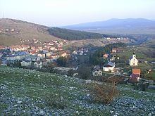
Kalinovik ( Serbian - Cyrillic Калиновик ) is a place in the eastern part of the Republika Srpska in Bosnia and Herzegovina and the seat of the municipality of the same name.
geography
The main town Kalinovik is 40 km south of Sarajevo on a karstified plateau at an altitude of about 1,100 m. A large part of the municipality is characterized by mountain ranges that rise up to 2,088 m in Treskavica .
Neighboring municipalities are Foča , Foča-Ustikolina , Gacko , Konjic , Nevesinje and Trnovo .
history
From 1901 to 1918 there was a branch of the kuk artillery shooting school in Kalinovik , which specialized in the training of mountain artillery.
Even before the Bosnian War (1992–1995), Kalinovik was one of the country's poorest communities and economically backward.
population
At the 1991 census, Kalinovik had 4,667 inhabitants, including
- Serbs : 2,826 (60.55%)
- Bosniaks : 1,716 (36.76%)
- Yugoslavs : 46 (0.98%)
- Croatians : 17 (0.36%)
- Others: 62 (1.35%)
2,878 people lived in the main town, including
- Serbs : 2,147 (74.60%)
- Bosniaks : 634 (22.03%)
- Yugoslavs : 37 (1.29%)
- Croatians : 7 (0.24%)
- Others: 53 (1.84%)
The Serbs still make up the absolute majority of the population today. Even before the war, the community was marked by strong migration. In 1971 the population was 9,458.
The municipality comprises a total of 73 places: Bak, Bojići, Boljanovići, Borija, Božanovići , Brda, Bukvica, Cerova, Čestaljevo, Daganj, Dobro Polje, Dragomilići, Dubrava, Gapići, Golubići, Gradina, Graiseljići, Gvozno, Hotovlje, Hablanići, Jažići, Jelašca, Jezero, Kalinovik, Klinja, Kolakovići, Kovačići, Krbljine, Kruščica, Kuta, Kutine, Luko, Ljusići, Ljuta, Mekoča, Mjehovina, Mosorovići, Mušići, Nedavić, Obrločnikija, Obadi, Obaljusija Polje, Popovići, Porija, Presjedovac, Rajac, Rastovac, Ruđice, Sela, Sijerča, Sočani, Strane, Susječno, Šivolji, Tmuše, Tomišlja, Trešnjevica, Trnovica, Tuhobić, Ulog, Unukovićoš, Vizla, Virhovićoš, Vizla, Vihovićoš Vujinovići and Zelomići.
Personalities
- Ratko Mladić (* 1942 in Božanovići ), general and convicted war criminal
economy
The structural weakness of the region has resulted in a long-lasting rural exodus. Most of the remaining inhabitants are employed in agriculture, which, however, produces almost exclusively for their own use.
Due to the lack of infrastructure and the unclear mine situation , the tourist potential can not yet be used sufficiently.
A dam has been under construction on the upper Neretva near Ulog in the west of the municipality since 2010. The work was interrupted in 2013 due to insufficient stability of the subsurface and has not been resumed so far (as of February 2017). The dam would be the first on the previously largely natural upper reaches of the Neretva.
traffic
The north-eastern part of the municipality is crossed by the main road M18 (Sarajevo – Foča). Many settlements can only be reached via gravel roads and are often cut off from the outside world in winter.
Web links
- Website of the Kalinovik municipality
- Kalinovik on the website of the Federal Commissioner for Bosnia and Herzegovina (1998) ( Memento from December 12, 2007 in the Internet Archive )
Individual evidence
- ↑ http://rzs.rs.ba/front/article/3630/ Updated population figures for 2018 from the Institute for Statistics of the Republika Srpska. Retrieved June 9, 2019.
- ↑ Capital.ba: Rok za izgradnju HE Ulog produžen do 2020. godine. (June 13, 2016, accessed February 14, 2017).


