
Bratunac
|
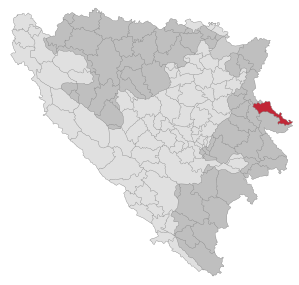
Bratunac Братунац |
|||
|
|
|||
|
|||
| Basic data | |||
|---|---|---|---|
| State : | Bosnia and Herzegovina | ||
| Entity : | Republika Srpska | ||
| Municipality : | Bratunac | ||
| Coordinates : | 44 ° 11 ' N , 19 ° 20' E | ||
| Height : | |||
| Area : | 293 km² | ||
| Residents : | 18,192 (2018) | ||
| Population density : | 62 inhabitants per km² | ||
| Postal code : | 75420 | ||
| Structure and administration (as of 2012) | |||
| Mayor : | Nedeljko Mlađenović ( SDS ) | ||
| Website : | |||
  |
|||


Bratunac ( Serbian - Cyrillic Братунац ) is a city in eastern Bosnia and Herzegovina . It is located about ten kilometers from Srebrenica near the Drina and the border with Serbia . Bratunac has belonged to the Republika Srpska since the Bosnian War .
history
The city was first mentioned in 1381 as a transit point between Bosnia and Serbia. At that time the village consisted of five houses with 30 inhabitants. The economic development begins in 1886 with the tobacco trade . The bridge between Bosnia and Serbia, which also functions as a border crossing, was built in 1926. In 1927 Bratunac became the town's seat for the first time.
population
The population composition has undergone major changes since 1991. This is due to the ethnic cleansing carried out by the army of the Republika Srpska . Many Bosniaks' houses were destroyed in the war, so few have returned to Bratunac in recent years. The number of returning Bosniaks is steadily increasing, not least thanks to the help of international organizations.
In the 1991 census, 21,535 inhabitants (64.05%) identified themselves as Bosniaks and 11,475 (34.13%) as Serbs . 532 residents (1.16%) stated other affiliations.
Until the 2013 census, the total population of Bratunac had fallen by around a third to 21,600 due to the war.
See also
Web links
Individual evidence
- ↑ http://rzs.rs.ba/front/article/3630/ Updated population figures for 2018 from the Institute for Statistics of the Republika Srpska. Retrieved June 9, 2019.

Banja Luka | Banovići | Berkovići | Bihać | Bijeljina | Bileća | Bos. Krupa | Bos. Brod | Bos. Petrovac | Šamac | Bos. Grahovo | Bratunac | Brčko | Breza | Bugojno | Busovača | Bužim | Cazin | Centar | Čajniče | Čapljina | Čelić | Čelinac | Čitluk | Derventa | Drvar | Doboj | Doboj Istok | Doboj Jug | Dobretići | Domaljevac-Šamac | Donji Vakuf | Donji Žabar | Foča | Foča-Ustikolina | Fojnica | Gacko | Glamoč | Goražde | Gornji Vakuf-Uskoplje | Gračanica | Gradačac | Gradiška | Grude | Hadžići | Han Pijesak | Ilidža | Ilijaš | Istočna Ilidža | Istočni Drvar | Istočni Mostar | Istočni Stari Grad | Istočno Novo Sarajevo | Jablanica | Jajce | Jezero | Kakanj | Kalesija | Kalinovik | Kiseljak | Kladanj | Ključ | Kneževo | Konjic | Kostajnica | Kotor Varoš | Kozarska Dubica | Kreševo | Krupa na Uni | Kupres | Kupres (RS) | Laktaši | Livno | Ljubinje | Ljubuški | Lopare | Lukavac | Maglaj | Milići | Modriča | Mostar | Mrkonjić degree | Neum | Nevesinje | Novi Grad | Novi Grad (Bos. Novi) | Novi Travnik | Novo Sarajevo | Odžak | Olovo | Orašje | Osmaci | Oštra Luka | Pale | Pale-Prača | Pelagićevo | Petrovac | Petrovo | Posušje | Prijedor | Prnjavor | Prozor-Rama | Ravno | Ribnik | Rogatica | Rudo | Sanski Most | Sapna | Sokolac | Srbac | Srebrenica | Srebrenik | Stari Grad | Stanari | Stolac | Šekovići | Šipovo | Široki Brijeg | Teočak | Teslić | Tešanj | Tomislavgrad | Travnik | Trebinje | Trnovo (RS) | Trnovo (FBiH) | Tuzla | Ugljevik | Usora | Ustiprača | Vareš | Velika Kladuša | Visoko | Višegrad | Vitez | Vlasenica | Vogošća | Vukosavlje | Zavidovići | Zenica | Zvornik | Žepče | Živinice