
Lopare
|
Lopare Лопаре |
|||
|
|
|||
|
|||
| Basic data | |||
|---|---|---|---|
| State : | Bosnia and Herzegovina | ||
| Entity : | Republika Srpska | ||
| Coordinates : | 44 ° 38 ' N , 18 ° 51' E | ||
| Height : | |||
| Area : | 280 km² | ||
| Residents : | 13,578 (2018) | ||
| Population density : | 48 inhabitants per km² | ||
| Telephone code : | +387 (0) 55 | ||
| Postal code : | 75240 | ||
| Structure and administration (as of 2016) | |||
| Mayor : | Rado Savić (Savez za promjene) | ||
| Website : | |||
  |
|||


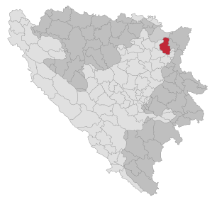
Lopare ( Serbian - Cyrillic Лопаре ) is a city and the associated municipality in northeastern Bosnia and Herzegovina . It is located 18 km northeast of Tuzla and belongs to the Republika Srpska . With the Treaty of Dayton , the northwestern part of the municipality was separated from Lopare by the entity boundary and has since formed the municipality of Čelić in the Federation .
geography
The municipality of Lopare is located in northeastern Bosnia between the north side of the Majevica mountain range ( 915 m ) and the landscapes of Posavina in the north and Semberija in the northeast. All streams in the municipality flow a few kilometers further north into the Save .
The municipality is bounded by the municipalities of Brčko in the north, Bijeljina and Ugljevik in the east, Sapna and Tuzla in the south and Čelić in the west. The borders to the three last-mentioned communities are also the inner-Bosnian entity border.
The municipality has 18 local communities: Piperi, Bobetino Brdo, Brusnica, Jablanica, Koraj, Koretaši, Lopare, Lukavica, Mačkovac, Milino Selo, Mirosavci, Mrtvica, Peljave, Pirkovci, Priboj, Puškovac, Tobut, Vakuf and Vukosavci. The 8 local communities Brnjik, Čelić, Drijenča, Humci, Ratkovići, Šibošnica, Velino Selo and Vražići have formed the municipality of Čelić since 1995 .
population
At the 1991 census, the municipality (including Čelić) had 32,537 inhabitants. Of these, 18,243 identified themselves as Serbs (56.07%), 11,990 as Bosniaks (36.85%) and 1263 as Croatians (3.88%). 1041 residents stated other affiliations (3.2%). Without Čelić, the municipality had 18,744 inhabitants, including 15,489 Serbs (82.63%) and 2525 Bosniaks (13.47%).
At that time, 2755 people lived in Lopare itself. Here, too, the Serbs made up the absolute majority with 2,415 residents (87.66%). 115 residents described themselves as Bosniaks (4.17%). Local communities with a Bosniak majority were Koraj (94.86%) and 6 out of 8 local communities in today's municipality of Čelić. In Drijenča the Croatians made up the majority (99%).
history
A necropolis with late Bronze Age grave goods was found near the village of Donji Bardačilovac near Lopare .
During the Bosnian War , Lopare was in the main combat area for a long time. The Bosnian government troops held a Muslim-settled area wedge that extended to the Serbian-held corridor of Brčko . From there they tried to break the connection between Serbia on the one hand and the areas around Banja Luka and Knin on the other. The predominantly Serbian settled community Lopare was located on the eastern flank of this wedge and was therefore an important strategic position for the VRS .
Sports
The largest and oldest football club in the municipality is FK Majevica Lopare. It was founded in 1933 and plays in the 2nd division of the Republika Srpska.
swell
- ↑ http://rzs.rs.ba/front/article/3630/ Updated population figures for 2018 from the Institute for Statistics of the Republika Srpska. Retrieved June 9, 2019.
- ↑ Peter König: Late Bronze Age hoards from Bosnia and Herzegovina , Franz Steiner Verlag 2004, page 112.
Web links

Banja Luka | Banovići | Berkovići | Bihać | Bijeljina | Bileća | Bos. Krupa | Bos. Brod | Bos. Petrovac | Šamac | Bos. Grahovo | Bratunac | Brčko | Breza | Bugojno | Busovača | Bužim | Cazin | Centar | Čajniče | Čapljina | Čelić | Čelinac | Čitluk | Derventa | Drvar | Doboj | Doboj Istok | Doboj Jug | Dobretići | Domaljevac-Šamac | Donji Vakuf | Donji Žabar | Foča | Foča-Ustikolina | Fojnica | Gacko | Glamoč | Goražde | Gornji Vakuf-Uskoplje | Gračanica | Gradačac | Gradiška | Grude | Hadžići | Han Pijesak | Ilidža | Ilijaš | Istočna Ilidža | Istočni Drvar | Istočni Mostar | Istočni Stari Grad | Istočno Novo Sarajevo | Jablanica | Jajce | Jezero | Kakanj | Kalesija | Kalinovik | Kiseljak | Kladanj | Ključ | Kneževo | Konjic | Kostajnica | Kotor Varoš | Kozarska Dubica | Kreševo | Krupa na Uni | Kupres | Kupres (RS) | Laktaši | Livno | Ljubinje | Ljubuški | Lopare | Lukavac | Maglaj | Milići | Modriča | Mostar | Mrkonjić degree | Neum | Nevesinje | Novi Grad | Novi Grad (Bos. Novi) | Novi Travnik | Novo Sarajevo | Odžak | Olovo | Orašje | Osmaci | Oštra Luka | Pale | Pale-Prača | Pelagićevo | Petrovac | Petrovo | Posušje | Prijedor | Prnjavor | Prozor-Rama | Ravno | Ribnik | Rogatica | Rudo | Sanski Most | Sapna | Sokolac | Srbac | Srebrenica | Srebrenik | Stari Grad | Stanari | Stolac | Šekovići | Šipovo | Široki Brijeg | Teočak | Teslić | Tešanj | Tomislavgrad | Travnik | Trebinje | Trnovo (RS) | Trnovo (FBiH) | Tuzla | Ugljevik | Usora | Ustiprača | Vareš | Velika Kladuša | Visoko | Višegrad | Vitez | Vlasenica | Vogošća | Vukosavlje | Zavidovići | Zenica | Zvornik | Žepče | Živinice