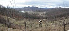
Majevica
Majevica is a low mountain range in the northeast of Bosnia and Herzegovina , between the plains of Posavina and Semberija in the north and the Spreča lowland ( Sprečko polje ) in the south.
The highest point is Mount Stolice (916 m) near Tuzla . Some other mountains reach heights between 800 and 900 m. Most of the Majevica is forested.
From NW to SE ( e.g. from Srebrenik towards Zvornik ) Okresnica 815 m, Opakovica 690 m, Stublić 721 m, Tabakove strane 572 m, Kicelj 673 m, Gavranić 720 m, Greda 803 m, Međednik 842 m, Busija 845 m belong to the main ridge , Draganovac 779 m, Konjic 903 m, Stolice 916 m, Mala Jelica 879 m, Velika Jelica 878 m.
swell
Web links
Coordinates: 44 ° 31 ' N , 18 ° 53' E

