
Ribnik (Bosnia)
|
Ribnik Рибник |
|||
|
|
|||
|
|||
| Basic data | |||
|---|---|---|---|
| State : | Bosnia and Herzegovina | ||
| Entity : | Republika Srpska | ||
| Coordinates : | 44 ° 25 ′ N , 16 ° 49 ′ E | ||
| Height : | 312 m. i. J. | ||
| Area : | 507 km² | ||
| Residents : | 5,388 (2018) | ||
| Population density : | 11 inhabitants per km² | ||
| Telephone code : | +387 (0) 50 | ||
| Postal code : | 79288 | ||
| Structure and administration (as of 2016) | |||
| Mayor : | Radenko Banjac ( SP ) | ||
| Website : | |||
  |
|||


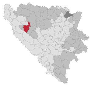
Ribnik ( Serbian - Cyrillic Рибник ) is a place and the associated municipality (opština) in the north-west of Bosnia and Herzegovina . It belongs to the Republika Srpska and was created by the entity boundary defined in the Dayton Treaty , which divided the municipality of Ključ . The north-western part of the former municipality, which is almost exclusively inhabited by Bosniaks , is now part of the Una-Sana canton in the Federation of Bosnia and Herzegovina .
After the Bosnian War , the municipality was first referred to as Srpski Ključ , before the Constitutional Court of the Republic of Bosnia and Herzegovina banned any ethnic reference in place names and the new name Ribnik was chosen after the municipality's seat.
geography
Ribnik is located between 300 and 1650 m altitude on the upper Sana , surrounded by the mountains Dimitor and Podovi in the east, Crna gora in the south and Klekovača and Srnetica in the west. The northern part of the municipality is in the Zmijanje ridge. The mountain ranges are densely forested; Forests make up 64% of the municipal area.
Ribnik is bordered by the municipalities of Ključ and Oštra Luka in the north, the city of Banja Luka in the northwest, Mrkonjić Grad in the east, Glamoč in the south and Istočni Drvar and Petrovac (RS) in the west.
Community structure
The municipality includes the villages Busije, Crkveno, Čađavica, Donja Previja, Donja Slatina, Donji Ribnik, Donji Vrbljani, Dragoraj, Gornja Previja, Gornja Slatina, Gornje Sokolovo, Gornji Ribnik, Gornji Vrbljaniž, Rastoka, Tresknica, Sredice, Straavac Velijašnica, Velije and Zableće and parts of the villages Donje Ratkovo, Donje Sokolovo, Gornje Ratkovo, Jarice and Ljubine.
population
At the 2013 census, the municipality of Ribnik had around 6,500 inhabitants, making it one of the smaller association municipalities in Bosnia. The Serbs make up the majority of the population . In the 1991 census, 99.5% of the population in the area of today's municipality identified themselves as Serbs. The inhabitants of Ribnik live almost exclusively in the settlements along the Sana and Ribnik rivers. The surrounding mountains are not populated.
history
The village of Zableće north of Ribnik was first mentioned as a fortress on the right bank of the Sana in 1530/31. During the Second World War Ribnik belonged to the non-occupied area of Bosnia-Herzegovina for a long time. Ribnik was founded in 1945, but in 1965 it was attached to the neighboring municipality of Ključ. After the Bosnian War , the municipality was deserted for a few months before the first refugees returned.
administration
The municipality is divided into the five village communities Crkvina, Previja, Ribnik, Sitnica and Vrbljani. All village communities have their own village council, which is elected by the population. The community center is Ribnik. The municipal council has 17 members.
economy
Due to its location in the middle of densely forested mountains, the timber industry in the Ribnik municipality plays a major role. In Vučija Poljana in the west of the municipality there are several large tourist buildings that are currently not in use. The southern municipality is largely untouched.
traffic
Ribnik Gornji used to be the terminus of a branch line of the narrow-gauge Steinbeisbahn coming from Srnetica .
swell
- ↑ http://rzs.rs.ba/front/article/3630/ Updated population figures for 2018 from the Institute for Statistics of the Republika Srpska. Retrieved June 9, 2019.
- ↑ Archived copy ( Memento of the original from July 28, 2009 in the Internet Archive ) Info: The archive link was automatically inserted and not yet checked. Please check the original and archive link according to the instructions and then remove this notice.
- ↑ Archived copy ( Memento of the original from July 28, 2009 in the Internet Archive ) Info: The archive link was automatically inserted and not yet checked. Please check the original and archive link according to the instructions and then remove this notice.
Web links

Banja Luka | Banovići | Berkovići | Bihać | Bijeljina | Bileća | Bos. Krupa | Bos. Brod | Bos. Petrovac | Šamac | Bos. Grahovo | Bratunac | Brčko | Breza | Bugojno | Busovača | Bužim | Cazin | Centar | Čajniče | Čapljina | Čelić | Čelinac | Čitluk | Derventa | Drvar | Doboj | Doboj Istok | Doboj Jug | Dobretići | Domaljevac-Šamac | Donji Vakuf | Donji Žabar | Foča | Foča-Ustikolina | Fojnica | Gacko | Glamoč | Goražde | Gornji Vakuf-Uskoplje | Gračanica | Gradačac | Gradiška | Grude | Hadžići | Han Pijesak | Ilidža | Ilijaš | Istočna Ilidža | Istočni Drvar | Istočni Mostar | Istočni Stari Grad | Istočno Novo Sarajevo | Jablanica | Jajce | Jezero | Kakanj | Kalesija | Kalinovik | Kiseljak | Kladanj | Ključ | Kneževo | Konjic | Kostajnica | Kotor Varoš | Kozarska Dubica | Kreševo | Krupa na Uni | Kupres | Kupres (RS) | Laktaši | Livno | Ljubinje | Ljubuški | Lopare | Lukavac | Maglaj | Milići | Modriča | Mostar | Mrkonjić degree | Neum | Nevesinje | Novi Grad | Novi Grad (Bos. Novi) | Novi Travnik | Novo Sarajevo | Odžak | Olovo | Orašje | Osmaci | Oštra Luka | Pale | Pale-Prača | Pelagićevo | Petrovac | Petrovo | Posušje | Prijedor | Prnjavor | Prozor-Rama | Ravno | Ribnik | Rogatica | Rudo | Sanski Most | Sapna | Sokolac | Srbac | Srebrenica | Srebrenik | Stari Grad | Stanari | Stolac | Šekovići | Šipovo | Široki Brijeg | Teočak | Teslić | Tešanj | Tomislavgrad | Travnik | Trebinje | Trnovo (RS) | Trnovo (FBiH) | Tuzla | Ugljevik | Usora | Ustiprača | Vareš | Velika Kladuša | Visoko | Višegrad | Vitez | Vlasenica | Vogošća | Vukosavlje | Zavidovići | Zenica | Zvornik | Žepče | Živinice