
Osmaci
|
Osmaci Осмаци |
|||
|
|||
| Basic data | |||
|---|---|---|---|
| State : | Bosnia and Herzegovina | ||
| Entity : | Republika Srpska | ||
| Coordinates : | 44 ° 23 ' N , 18 ° 54' E | ||
| Height : | 280 m. i. J. | ||
| Area : | 71 km² | ||
| Residents : | 5,380 (2018) | ||
| Population density : | 76 inhabitants per km² | ||
| Structure and administration (as of 2016) | |||
| Mayor : | Ljubo Petrović ( SDS ) | ||
| Website : | |||
  |
|||

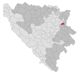
Osmaci ( Serbian - Cyrillic Осмаци ) is a municipality in northeastern Bosnia and Herzegovina . It belongs to the Republika Srpska and was created by the separation of the eastern part of the Kalesija community as a result of the Dayton Agreement after the Bosnian War . The remaining three quarters of the old municipality of Kalesija now belong to the Federation of Bosnia and Herzegovina .
geography
The municipality is located between the towns of Kalesija and Zvornik . The districts are between 200 and 400 meters above sea level.
The municipality includes the villages of Borogovo, Caparde, Gojčin (unpopulated part), Hajvazi, Kosovača, Kulina, Kusonje, Mahala, Matkovac, Osmaci (partly), Rakino Brdo, Sajtovići, Šeher, Viličevići and Zelina (partly).
population
At the last census in 1991 those populated districts of Kalesija, which today form the municipality of Osmaci, had a total of 7252 inhabitants. Of these, 4034 described themselves as Serbs (55.6%) and 3170 as Bosniaks (43.7%). Nine villages had a Serb majority and five a Bosniak majority. Only Serbs lived in the three villages of Borogovo, Kosovača and Rakino Brdo.
At the 2013 census, Osmaci had a total of 6,000 inhabitants.
Infrastructure
Magistralstrasse 4 ( Tuzla – Zvornik) and the Tuzla – Zvornik railway line run through the municipality .
Individual evidence
- ↑ http://rzs.rs.ba/front/article/3630/ Updated population figures for 2018 from the Institute for Statistics of the Republika Srpska. Retrieved June 9, 2019.
- ↑ Preliminary results of the 2013 census (PDF; 752 kB)

Banja Luka | Banovići | Berkovići | Bihać | Bijeljina | Bileća | Bos. Krupa | Bos. Brod | Bos. Petrovac | Šamac | Bos. Grahovo | Bratunac | Brčko | Breza | Bugojno | Busovača | Bužim | Cazin | Centar | Čajniče | Čapljina | Čelić | Čelinac | Čitluk | Derventa | Drvar | Doboj | Doboj Istok | Doboj Jug | Dobretići | Domaljevac-Šamac | Donji Vakuf | Donji Žabar | Foča | Foča-Ustikolina | Fojnica | Gacko | Glamoč | Goražde | Gornji Vakuf-Uskoplje | Gračanica | Gradačac | Gradiška | Grude | Hadžići | Han Pijesak | Ilidža | Ilijaš | Istočna Ilidža | Istočni Drvar | Istočni Mostar | Istočni Stari Grad | Istočno Novo Sarajevo | Jablanica | Jajce | Jezero | Kakanj | Kalesija | Kalinovik | Kiseljak | Kladanj | Ključ | Kneževo | Konjic | Kostajnica | Kotor Varoš | Kozarska Dubica | Kreševo | Krupa na Uni | Kupres | Kupres (RS) | Laktaši | Livno | Ljubinje | Ljubuški | Lopare | Lukavac | Maglaj | Milići | Modriča | Mostar | Mrkonjić degree | Neum | Nevesinje | Novi Grad | Novi Grad (Bos. Novi) | Novi Travnik | Novo Sarajevo | Odžak | Olovo | Orašje | Osmaci | Oštra Luka | Pale | Pale-Prača | Pelagićevo | Petrovac | Petrovo | Posušje | Prijedor | Prnjavor | Prozor-Rama | Ravno | Ribnik | Rogatica | Rudo | Sanski Most | Sapna | Sokolac | Srbac | Srebrenica | Srebrenik | Stari Grad | Stanari | Stolac | Šekovići | Šipovo | Široki Brijeg | Teočak | Teslić | Tešanj | Tomislavgrad | Travnik | Trebinje | Trnovo (RS) | Trnovo (FBiH) | Tuzla | Ugljevik | Usora | Ustiprača | Vareš | Velika Kladuša | Visoko | Višegrad | Vitez | Vlasenica | Vogošća | Vukosavlje | Zavidovići | Zenica | Zvornik | Žepče | Živinice