
Sarajevo-Novi Grad
|
Novi grad Нови град |
|||
|
|
|||
|
|||
| Basic data | |||
|---|---|---|---|
| State : | Bosnia and Herzegovina | ||
| Entity : | Federation of BiH | ||
| Canton : | Sarajevo | ||
| Coordinates : | 43 ° 51 ' N , 18 ° 23' E | ||
| Height : | 505 m. i. J. | ||
| Area : | 48 km² | ||
| Residents : | 124,471 (2013) | ||
| Population density : | 2,593 inhabitants per km² | ||
| Telephone code : | +387 (0) (+387) 33 | ||
| Postal code : | 71000 | ||
| Structure and administration (as of 2012) | |||
| Mayor : | Semir Efendić ( SDA ) | ||
| Website : | |||
  |
|||


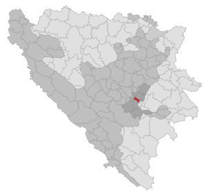
Novi Grad ("New Town") is the westernmost and with almost 125,000 inhabitants largest municipality ( općina ) in the urban area of the Bosnian capital Sarajevo and the second largest municipality in the whole country after Banja Luka . It was separated from the previous municipality of Novo Sarajevo on April 12, 1978 and consists mainly of prefabricated buildings from the 1970s and 1980s along the Miljacka and housing estates with smaller houses on the mountain slopes in the north and south. Novi Grad borders on the municipalities of Ilijaš and Vogošća in the north, Novo Sarajevo in the east, Istočno Novo Sarajevo in the southeast and Ilidža in the west.
There are extensive industrial and railway facilities on the territory of the Novi Grad municipality, as well as representative business centers such as Bosmal City Center . One of the religious centers is the new Istiklal Mosque in the Miljacka loop in Otoka. The two largest residential areas are Alipašino polje and Dobrinja near the airport. The latter in particular was right on the front border during the Bosnian War and suffered severe damage. This is where the inner Bosnian entity border to the Republika Srpska runs today .
The main part of the municipality is located at about 500 m altitude in the flat Sarajevo polje , while the Žuč mountain is the highest point at 850 meters.

Web links

Banja Luka | Banovići | Berkovići | Bihać | Bijeljina | Bileća | Bos. Krupa | Bos. Brod | Bos. Petrovac | Šamac | Bos. Grahovo | Bratunac | Brčko | Breza | Bugojno | Busovača | Bužim | Cazin | Centar | Čajniče | Čapljina | Čelić | Čelinac | Čitluk | Derventa | Drvar | Doboj | Doboj Istok | Doboj Jug | Dobretići | Domaljevac-Šamac | Donji Vakuf | Donji Žabar | Foča | Foča-Ustikolina | Fojnica | Gacko | Glamoč | Goražde | Gornji Vakuf-Uskoplje | Gračanica | Gradačac | Gradiška | Grude | Hadžići | Han Pijesak | Ilidža | Ilijaš | Istočna Ilidža | Istočni Drvar | Istočni Mostar | Istočni Stari Grad | Istočno Novo Sarajevo | Jablanica | Jajce | Jezero | Kakanj | Kalesija | Kalinovik | Kiseljak | Kladanj | Ključ | Kneževo | Konjic | Kostajnica | Kotor Varoš | Kozarska Dubica | Kreševo | Krupa na Uni | Kupres | Kupres (RS) | Laktaši | Livno | Ljubinje | Ljubuški | Lopare | Lukavac | Maglaj | Milići | Modriča | Mostar | Mrkonjić degree | Neum | Nevesinje | Novi Grad | Novi Grad (Bos. Novi) | Novi Travnik | Novo Sarajevo | Odžak | Olovo | Orašje | Osmaci | Oštra Luka | Pale | Pale-Prača | Pelagićevo | Petrovac | Petrovo | Posušje | Prijedor | Prnjavor | Prozor-Rama | Ravno | Ribnik | Rogatica | Rudo | Sanski Most | Sapna | Sokolac | Srbac | Srebrenica | Srebrenik | Stari Grad | Stanari | Stolac | Šekovići | Šipovo | Široki Brijeg | Teočak | Teslić | Tešanj | Tomislavgrad | Travnik | Trebinje | Trnovo (RS) | Trnovo (FBiH) | Tuzla | Ugljevik | Usora | Ustiprača | Vareš | Velika Kladuša | Visoko | Višegrad | Vitez | Vlasenica | Vogošća | Vukosavlje | Zavidovići | Zenica | Zvornik | Žepče | Živinice