
Ankara
| Ankara | ||||
|
||||
 Ankara |
||||
| Basic data | ||||
|---|---|---|---|---|
| Province (il) : | Ankara | |||
| Coordinates : | 39 ° 55 ' N , 32 ° 51' E | |||
| Height : | 938 m | |||
| Surface: | 25,706 km² | |||
| Residents : | 5,639,076 (2019) | |||
| Population density : | 219 inhabitants per km² | |||
| Telephone code : | (+90) 312 | |||
| Postal code : | 06 000 | |||
| License plate : | 06 | |||
| Structure and administration (as of 2019) | ||||
| Structure : | 25 İlçe | |||
| Büyükşehir Belediye Başkanı: | Mansur Yavaş ( CHP ) | |||
| Website: | ||||


Ankara [ ˈaŋkara ], formerly Angora (ancient name from ancient Greek Ἄγκυρα Ankyra , Latin Ancyra ), has been the capital of Turkey and the province of Ankara since 1923 .
The city, which according to Turkish law is a metropolitan municipality ( Büyükşehir Belediyesi ) and is now identical in area and population to the province of the same name, had around 5.6 million inhabitants in 2019, making it the second largest city in the country after Istanbul .

Etymology and name of the city
The exact etymological origin of the name Ankara is not known. Pausanias reports that King Midas found an anchor at the site and then founded the city there as Ankyra (Greek for anchor) according to the subject . Stephanos of Byzantium claims that the Galatians brought an anchor as a war trophy after the victory against the Ptolemies from Egypt and immortalized this designation in the city's name when the city was founded. Coins with an anchor motif are known. On the other hand, there are indications that the city name has been used in a similar form since the Phrygians or even the Hittites and was later converted to Ankyra by the Greeks.
Similarly, during the Islamic period of Ankara, the thesis was put forward that the name of the city, then called Engürü, came from the Persian word for grape ( engûr ), which refers to the lush wine-growing regions around Ankara.
On March 28, 1930, the capital was given the official name Ankara instead of the name form Angora that had been used by Europeans and in dealings with Europeans until then in Latin script - influenced by the modern Greek pronunciation . The Turkish forms of the name were previously Engüriye , Engürü or Engüri ; earlier forms of the name were Greek Ankyra , Latin Ancyra , Arabic Anḳira and Anḳuriyya or Ḳalʿat al-Salāsil , in German "chain fortress ".
Geography and climate

Ankara is about 900 to 1050 meters above sea level and has a strictly dry continental climate , which is characterized by hot dry summers and cold, snowy winters. The city lies south at the foot of the Köroğlu Mountains and stretches south towards the Konya Plateau. The annual average temperature is 12.2 ° C. The warmest months are July and August with an average of almost 24 ° C, the coldest January and February with temperatures a little above freezing point. Most precipitation falls in April with an average of 51 millimeters, the lowest precipitation is recorded for the month of August with an average of 12 millimeters. The annual total of precipitation averages 404 mm; this makes Ankara one of the driest areas in Turkey.
In the city, two small streams called Hatip Çayı , also called Bent Deresi , and Çubuk Çayı unite to form the Ankara River ( Ankara Çayı ), which is largely overbuilt and heavily polluted in the city.
| Ankara, Keçiören (891 m) | ||||||||||||||||||||||||||||||||||||||||||||||||
|---|---|---|---|---|---|---|---|---|---|---|---|---|---|---|---|---|---|---|---|---|---|---|---|---|---|---|---|---|---|---|---|---|---|---|---|---|---|---|---|---|---|---|---|---|---|---|---|---|
| Climate diagram | ||||||||||||||||||||||||||||||||||||||||||||||||
| ||||||||||||||||||||||||||||||||||||||||||||||||
|
Monthly average temperatures and precipitation for Ankara, Keçiören (891 m)
|
||||||||||||||||||||||||||||||||||||||||||||||||||||||||||||||||||||||||||||||||||||||||||||||||||||||||||||||||||||||||||||||||||||||||||||||||||||||
history
Ancient and Byzantine times

Originally a flourishing Phrygian settlement on the Persian Royal Road , it became the capital of the Roman province of Galatia in Roman times . The Celtic Galatians came to Anatolia as mercenaries in the 3rd century BC and there initially developed into a nuisance. After they started in 268 BC Were settled in the interior of Asia Minor, Ancyra became the center of the Galatian tribe of the Tectos sagas . 189 BC Ancyra was occupied by Gnaeus Manlius Vulso , but remained under regional rule. The Galatians were only born in 44 BC. After Caesar's assassination by King Deiotaros united under one rule, but already 25 BC. BC Galatia became a Roman province and Ancyra its capital. The temple of Augustus , on the walls of which there is an inscription that has become famous as the Monumentum Ancyranum , the Roman baths and the Julian's column have been preserved from Roman times .
When the Roman Empire was divided after the death of Emperor Theodosius I in 395, the city fell to the Eastern Roman Empire, which was later called the Byzantine Empire , and belonged to it until 1073. In 620 advancing Sassanids conquered the city and held it for seven years. The Byzantines made the city from 717-775 the military headquarters of their administrative unit Bukellarion . Ankara was conquered several times by Arab troops under the Abbasid caliphs Hārūn ar-Raschīd (797) and al-Mu'tasim bi-'llāh (838) and taken again by the Byzantines after a few years. The Paulikians , described by the Byzantines as a heretical group, were able to take the city briefly (871); like the Abbasid troops (931), they were also thrown back again. The impressive fortification walls of the citadel and the church built into the Augustus temple, of which the apse and the small crypt are still preserved, date from the Byzantine period .
Seljuks and Ottomans
After Alp Arslan's victory in the Battle of Manzikert in 1071, the Byzantine imperial administration in Anatolia was temporarily dissolved completely. In the anarchic conditions that arose in this way, Turkish tribal groups settled in Anatolia, to which often rival aristocratic factions in the Byzantine cities of Asia Minor opened the gates in order to use the military capabilities of these groups for their own purposes. In the course of the consolidation and centralization of the rule of these Turkish groups under a Seljuk branch line, Ankara came under the rule of the Sultanate of the Rum Seljuks . After the Mongol invasion in 1243 and the collapse of the Seljuk state, small independent principalities, the Beyliks , took control of the western Anatolian border areas ( Uc ), while eastern Anatolia and eastern central Anatolia fell under the direct rule of the Mongolian Ilkhans and later also under the rule of Turkish princes . Here Ankara was in the border area between the border principalities of the Uc, namely the Ottomans and the caramans and the rulership of the Ilkhan. In this rule vacuum, Ankara, like comparable cities, came under the rule of the Ahi .


As the offshoots of the Futuwwa movement, the Ahi were guild-like brotherhoods of the urban population, such as the craftsmen, whose leaders took on state tasks in the absence of other rulers. In 1356 Orhan I conquered Ankara and incorporated it into the Ottoman Empire , which was to determine its development from then on - with the exception of the occupation 1401–1402 by Timur after the battle of Ankara - until the First World War. Ankara was the capital of a sanjak in Eyâlet Anadolu and in 1841 it became the administrative seat of the newly formed Eyalets of the same name (from 1867 Vilâyet Ankara ). Ankara has been connected to Istanbul by the Anatolian Railway since 1892 .
After the defeat of the Ottomans in World War I, allied forces occupied what was then the capital, Istanbul. Ankara was also occupied and evacuated by Allied troops led by Withall for a short time after the Ottoman declaration of surrender in 1919. In the Anatolian heartland, resistance formed against the occupying powers, and after Mustafa Kemal's arrival in Ankara at the end of 1919, the Grand National Assembly of Turkey was proclaimed in 1920 , as the Ottoman Parliament in Istanbul was under pressure from the British occupation and many of its MPs passed after its dissolution the British were imprisoned and deported to Malta. When the Greek occupation troops advanced as far as Polatlı (about 60 km from Ankara) in 1921 and the artillery bombardment could already be heard in Ankara, parliament was considering moving to Kayseri , which was not done after the successful battle on Sakarya .
.jpg)
republic
With the final victory of the troops led by Kemal Ataturk in the Turkish Liberation War , Ankara was declared capital in the run-up to the proclamation of the republic on October 13, 1923, due to its location in Central Anatolia and deliberately delimiting it from the Ottoman capital Istanbul . As the representative capital of the young republic, the infrastructure first had to be provided. Most of the city was destroyed by a fire in 1917, the surrounding area was swampy ( malaria was a big problem) and there was a steady influx of people. In eight years (1920–1928) the population quadrupled from approx. 25,000 to 100,000. The new concept was largely based on German architects. The basic urban planning was based on a plan developed by Carl Christoph Lörcher for 1924–1925, which was later developed reassessed due to larger influx and was redesigned by Hermann Jansen, who was in Turkish service from 1929, in the so-called "Jansen Plan". Clemens Holzmeister built the parliament building, several ministries and courthouses as well as a villa for Ataturk.

In the decades that followed, the city administration had to deal with the rural exodus that became visible in Gecekondu districts. Since the 1950s at the latest, prestigious buildings have been abandoned more and more; the cityscape in the center is dominated by large, functional rectangular buildings and roads. The capital planned as a “green city in the middle of the Anatolian steppe” lost a lot of urban green space. In the mid-1980s, the so-called TOKI tried to solve the housing and space problem across Turkey with cheap high-rise developments, which have dominated Ankara's cityscape since then. From 1994 to 2017 the Islamic conservative Melih Gökçek was the mayor. In 2009, the city was for their outstanding efforts towards European integration with the European Prize awarded. In 2014, the new official residence of the President was inaugurated, which was built on the green space of Ataturk's forest farm despite the legal construction freeze and cost almost half a billion euros. On October 10, 2015, during a demonstration at the city's train station , a terrorist bomb attack resulted in over 100 deaths. In 2017 Gökçek was replaced as mayor by Mustafa Tuna, who also belongs to the AKP , but who narrowly defeated his challenger Mansur Yavaş from the CHP in the 2019 local elections .
coat of arms
.jpg&filetimestamp=20090925192458&)
The city's coat of arms has been a longstanding controversial issue. The coat of arms or emblem that was accepted for decades was the disk-shaped standard known as the "Hittite sun" ( bronze standards by Alaca Höyük ). It was replaced in 1995 by the longtime mayor from 1994-2017 Melih Gökçek , a member of the Islamic-conservative AKP from 2002 , with a picture of the Kocatepe Mosque , which with its classical architecture is very similar to other mosques in Turkey and was completed in 1987. Various court rulings criticized the lack of representative symbolism and criticized the mayor's violations of authority. In response, he integrated the Atakule television tower into the coat of arms. Gökcek later proposed two cat eyes of the Turkish Angora cat breed as a coat of arms; however, the proposal was withdrawn due to protests. The question of the coat of arms remains a controversial issue.
Economy and Infrastructure
Economy and tourism


Ankara is not only the administrative center of Turkey, but is also one of the largest economic centers in the country alongside Istanbul and Izmir . The armaments industry is important, such as TUSAS Turkish Aerospace Industries, ASELSAN (military technology) or the MKE ammunition and weapons industry, Roketsan or Havelsan. There is also a large MAN bus factory near the airport, a tractor factory, a construction machinery manufacturer ( Hidromek ), as well as companies in the food and luxury goods industry, while the formerly important goat and wool processing industry has become meaningless. Most of the industrial operations are concentrated in the west of the city. Most of the city's shopping and commercial center is located in Kızılay around Kızılay Square .
Compared to the other Turkish cities, Ankara is not very touristy. This is mostly explained with the prevailing image of an ungreened official city. The most visited places include the mausoleum of the state founder Ataturk and the Museum of Anatolian Civilizations. The visit is usually part of a larger tour, such as B. organized on a trip to Cappadocia . For the religious domestic tourists, the Hacı-Bayram Mosque is a place of pilgrimage.
According to a study from 2014, Ankara has a gross domestic product of 104.86 billion US dollars in purchasing power parity. In the ranking of the economically strongest metropolitan regions worldwide, the city took 129th place. The GDP per capita is US $ 21,076 (PPP).
education
Ankara is the seat of several universities, u. a. the University of Ankara , the Bilkent University , the Gazi University , the Technical University of the Middle East (METU), the Hacettepe University , the TOBB University of Economics and high technology , the Ufuk University , the Atılım University , Çankaya- University and Başkent University .
traffic
Roads and public transport

The quality of the roads varies. While it is bad in the old Ulus city center, the streets around Kızılay , the new city center, are being renewed. The eight-lane O-20 ring road will help relieve urban traffic. As in other large cities, there are numerous taxis. As in most Turkish cities, a significant part of local public transport is handled by Dolmuş .
Local public transport is largely carried out with buses . There are several bus stations, u. a. the Ankara Şehirlerarası Otobüs Terminali .
In 2014 the metro consists of four lines M1, M2, M3 and Ankaray. Another line (M4) is under construction, one line is in long-term planning. There is also a S-Bahn (S-Bahn) (Banliyö Trenleri) .
A 3.2 km long detachable cable car with four stations has been connecting the Şentepe district with the Yenimahalle metro station since 2014 . The city administration has decided to make the system available to all users free of charge, so no tickets are necessary. The cable car was built by the South Tyrolean company Leitner ropeways .
Airports
Ankara has several military (including Güvercinlik Havalimanı, Etimesgut Havalimanı) and an international civil airport, Esenboğa Airport . It is located 28 km northeast of the city and was completely renovated between 2004 and the end of 2006. At the same time, the airport was connected to the ring road via an expressway.
railroad

Ankara was connected to Istanbul by the Anatolian Railway at the end of the 19th century and to Izmir via a branch . Lines were later built via Kayseri to the east of the country, to the Baghdad Railway towards Adana and via Karabük to the Black Sea coast .
The Ankara – Istanbul high-speed line went into operation in January 2009. The Ankara – Konya high-speed line has been in operation since August 30, 2011. High-speed lines to Sivas , Kars and Izmir are planned and should be completed by 2015. [obsolete] The TCDD Açık Hava Buharlı Lokomotif Müzesi (Steam Locomotive Museum) contains various historical tractors.
population

Before 1923, Ankara had a population of around 25,000. After receiving capital city status, it became the city with the third largest population after Istanbul and Izmir, and ranked second nationwide in 2014. It is one of the cities with the greatest influx of internal migrants. The entire province has 5,045,085 inhabitants. Since the last administrative reform in 2014, the Ankara Metropolitan Municipality ( Ankara Büyükşehir Belediyesi ) covers the entire area of the province. Before this reform, of the provincial population, 4,630,735 people lived in the city of Ankara. At the macro level, Ankara is home to almost a third of the inhabitants of Central Anatolia (11,608,868). The urban population of Ankara lives 97% in an urban and 3% in a village environment.
In the period 1990-2000, the urban population grew from 2,583,963 by 21.48%. In comparison, the growth rates in Central Anatolia during this period were 15.78% and for the whole of Turkey 18.28%.
| Population distribution according to age groups | ||||
| 0-4 | 367,578 |
|
||
| 5 - 9 | 375.817 |
|
||
| 10-14 | 365.787 |
|
||
| 15-19 | 391.215 |
|
||
| 20-24 | 417,387 |
|
||
| 25-29 | 443.379 |
|
||
| 30-34 | 460,947 |
|
||
| 35-39 | 429.172 |
|
||
| 40-44 | 397,641 |
|
||
| 45-49 | 349,345 |
|
||
| 50-54 | 326.133 |
|
||
| 55-59 | 257.783 |
|
||
| 60-64 | 191.931 |
|
||
| 65-69 | 139,524 |
|
||
| 70-74 | 93,938 |
|
||
| 75-79 | 64,449 |
|
||
| 80-84 | 48,870 |
|
||
| 85-89 | 22,129 |
|
||
| 90+ | 7,047 |
|
While in Ankara 1,585,970 residents are registered with the Ankara Home Residential Registration Office, there is a larger group that is still registered in the original home provinces. The largest immigration comes from the provinces of Çorum with 378,451, followed by Yozgat 332,198, Çankırı 236,406, 196,296 Kırşehir , 180,595 Kırıkkale and 151,386 Sivas , accordingly mostly from Central Anatolia. From outside Central Anatolia 103,319 newcomers come from Erzurum , followed by 81,830 from Kars and 82,305 from Bolu . Ankara has the smallest arrivals from Kırklareli , Hakkari and Yalova .
Religion and beliefs
The residents are mostly of Muslim faith. The city came into contact with Christianity early on . According to the northern Galatian hypothesis, the apostle Paul of Tarsus called on the residents of Ankara to convert to Christianity in the first century ( Paul’s letter to the Galatians ). With the Byzantines, the Roman Augustus temple was transformed into an important church in the city. In 1520 the proportion of non-Muslims in the city was 10% and increased to 45% due to the influx of mostly Catholic Armenians in 1830. In the course of the ethnic tensions leading up to the First World War and the deportation of the Armenians during the genocide , the Christian community has shrunk considerably. The city has some more modern churches (Protestant, Catholic, Orthodox). There is also a 100-member Jewish community with a synagogue , the Havra .
Personalities
Ankara is the birthplace of numerous prominent personalities. See the list of sons and daughters of the city of Ankara
Cityscape

The winding, narrow streets of the old town wind around a steep rock cone crowned by the citadel . South of the old town and the old city center Ulus extends the modern new town with the new centers Kızılay and Kavaklıdere, which are characterized by wide boulevards, numerous government buildings and embassies as well as modern residential areas. In the western part of the city in particular, new housing estates are emerging in order to meet the growing demand for living space. Despite these efforts, there were still very many marginal settlements ( Gecekondu ) up into the first decade of the 21st century . Since the turn of the millennium, a large part of these gecekondus has been torn down, re-planned and replaced by spacious, modern high-rise estates. Ankara received today's structures mainly from the German town planner Hermann Jansen , whose plans were implemented in the late 1920s. In the Hamamönü district of the Altındağ municipality , historic 19th-century houses were restored from 2009 and now house cafes, galleries and souvenir shops. In the last 15 years, lignite has been largely replaced as a heating medium by the more environmentally friendly natural gas . Nevertheless, due to the steady population growth, the air pollution in Ankara is increasing sharply, the old buses, cars and the lack of a more environmentally friendly alternative contribute significantly to this.
Green spaces

In the first urban development plans of the young republic, Ankara was planned as a green city in the middle of the barren Anatolian steppe. The second city planner Jansen planned it roughly as an Anatolian garden city , so large green belts were created that divided the city into functional units. A larger green area in the west of the city is the Ataturk Forest Farm , an agricultural and forestry demonstration company owned by Gazi, which supplied the population with raw milk , dairy products and local beer until the 1980s . At that time, three-story houses with back gardens were laid out for the residents of the city, a small number of which are still left in the Bahçelievler settlement today. With the onset of rural exodus from the 1950s, the green areas became the foundation for prefabricated buildings .
A well-known central park is the Gençlik Parkı , which was completed in the construction period 1938–1943 in the Ulus district. It was opened as a recreation park and changed its character more towards an entertainment park from the 1950s. After a complete renovation in 2006, it is a place for strolling families with evening light effects and music shows. One of the largest parks in the city is Altınpark (with 50.8 hectares) in the Altındağ district . It was built on a former golf course and completed in 1991 and offers not only relaxation but also opportunities for sporting activities (such as karting , ice rink ).
There are also several smaller parks, including Kurtuluş Parkı , Kuğulu Parkı , Gökçek Parkı and the 50th Yıl Parkı . The forest of the Technical University in the south of the city was a larger, semi-forested green area, but it is increasingly being built on, which leads to ongoing protests from students.
graveyards
The Turkish State Cemetery in the Yenimahalle district is one of the country's most important cemeteries . In its 536,000 m² area, it houses 61 graves of high-ranking officers and generals of the Turkish liberation war, graves of three presidents and one prime minister. Most of the burials were reburied there for the relatively modern project (construction time was 1981–1988). The whole cemetery is criss-crossed with sculptures and includes a museum with belongings of the deceased.
Another cemetery with notable burials is the Cebeci Municipal Cemetery in the Cebeci district. It was planned as a modern cemetery by the architect Martin Elsaesser during the republic and is confessionally mixed in the sense of secularism . Due to recent expansions, it has lost its old structure. It is now considered the second largest cemetery in the city. The largest civil cemetery is the Karşıyaka Cemetery with an area of 2.89 km².
Culture and sights
Roman legacies
In the Ulus district, the historic center of the city, are the Caracalla Baths , a Roman bathing complex from the 3rd / 4th centuries. Century. The foundation walls and the bricks of the hypocaust heating system have been preserved from the bathing buildings . Numerous steles , capitals and inscriptions that have been found in the city are erected on the place for sports exercises, the palaestra . About 400 meters east of it are the ruins of the Temple of the Roma and Augustus , on the walls of which the bilingual Greek / Latin report of the Emperor Augustus is attached. Close by is the Roman Julian's column , the exact time of its manufacture is not known.
Anıtkabir

The resting place of the state's founder, Mustafa Kemal Ataturk, is on the central hill of Anıttepe . After his death in 1938, an international architecture competition was called with the task of putting a suitable tomb for him. The design fell on a straightforward, rational, no-frills and monumental mausoleum with a central location and a view of the city. The system is in three parts: A narrow corridor (Löwenweg) leads to the ceremonial square, which can accommodate 15,000 people. The mausoleum contains the belongings of the general and statesman and a museum about the War of Independence . It is a nationally known national monument that has several million visitors every year (2015: approx. 5 million). For foreign state guests, it is a mandatory protocol visit.
Parliaments

Ankara includes three parliament buildings. The first historic parliament on Ulus-Platz was a Young Turkish clubhouse that was used as a parliament by the newly formed national movement in 1920. The war against the advancing Greeks and the attitude to the occupied Istanbul government were debated here during the War of Independence. Today it is a museum ( Kurtuluş Savaşı Müzesi ). The second historic parliament building was designed by the architect Vedat Tek due to the limited space and is in the direct vicinity of the first parliament. It was used from 1924 to 1961 and is now also a museum ( Cumhuriyet Müzesi ).
The third parliament, which is in service, was designed in 1938 by the winner of the architectural competition, Clemens Holzmeister , and completed in 1961.
citadel

The citadel of Ankara is a fortification built by the Hittites, expanded by the Galatians and finally used by the Ottomans in the middle of Ankara's old town. It is divided into the outer ( Dışkale ), inner castle complex ( İçkale ) and the castle itself ( Akkale ).
Mosques

The city's landmark and eye-catcher is the Kocatepe Mosque . It's the largest in town. Inside the mosque there are teahouses, a large supermarket and a conference room. The church was only completed in 1987 and is a recourse to the classic Ottoman architecture of Mimar Sinan . The well-known Maltepe Mosque , like many other mosques, is based on the same style. A historical mosque from the 16th century actually built by Mimar Sinan in Ankara is the New Mosque in the Ulus district.
The Doğramacızade Ali Sami Paşa Mosque , completed in 2008 and built in honor of his father by the founding father of many institutes, İhsan Doğramacı, is an architectural novelty . The architectural style, described as postmodern, is kept simple and the mosque conceptually allows non-Muslims to use the rooms on special occasions.
The Aslanhane Mosque is one of the oldest mosques in the city (13th century) . The name "Aslanhane" means "lion hall" and is due to the lion reliefs on the outer facade. The prayer room is supported by wooden pillars in typical Seljuk style. The Hacı Bayram Mosque was named after the poet and founder of the Bairami Sufi order, Hacı Bayram-i Veli , whose tomb is right in the back garden. It was completed in 1428 and has a minaret. Immediately adjacent to the mosque are the ruins of the Augustus temple . The mosque stands in the middle of a quarter with restored or in Ottoman style new or rebuilt buildings. The path to the mosque is lined with shops selling religious literature and devotional items .
Museums

One of the internationally most important archaeological museums in Turkey is the Museum of Anatolian Civilizations , which focuses on exhibits from the epochs up to the beginning of the first century BC, especially the Hittites .
The two former parliaments, which have been converted into museums, deal with the recent history of the republic. The museum in Anıtkabir also deals with the topic and shows, in addition to the founder's belongings, battles audiovisually on panoramic screens. It also houses national paintings and portraits of the founder of the state and the generals involved.
There are two museums built in the first national style on Namazgah Hill . The Ethnographic Museum Ankara is a folklore museum built in 1930 and focuses on exhibits from the Seljuk period: cooking, living and working environments and various art forms of the nomads and sedentary residents of Anatolia. Next to it is the State Art and Sculpture Museum, which was used as the headquarters of the Türk Ocağı and Halkevleri and is now an art museum. The Çengelhan Rahmi M. Koç Museum , which opened in 2006, is located in the former Çengelhan caravanserai and is specifically dedicated to the son of the Turkish economic pioneer Vehbi Koç . The industrial museum contains machines and equipment from the age of the beginning industrialization (communication, navigation, agriculture). There are also two science museums in the city, the Feza Gürsey Science Center in Altinpark and the Technology and Science Museum of the ODT University ( ODTÜ Bilim ve Teknoloji Müzesi ).
Stages

The Opera Sahnesi (German: Opernbühne ) is the largest of the three opera houses in Ankara. It belongs to the Turkish State Theaters ( Devlet Tiyatroları ).
- Ankara Opera Sahnesi ("Opera Stage", also known as Büyük Tiyatro )
- Leyla Gencer Sahnesi
- Operet Sahnesi
The following theaters in Ankara belong to the Turkish state theaters: 125th Yıl Çayyolu Sahnesi, Büyük Tiyatro ("Big Stage"), Küçük Tiyatro ("Small Stage"), Şinasi Sahnesi, Akün Sahnesi, Altındağ Tdaiyatrosu, Altındağ Tdaiyatrosu, İrbae Şrfanes Şrfan Şrfan ( Oda Tiyatrosu ), Mahir Canova Sahnesi, Muhsin Ertuğrul Sahnesi.
There are also five classical orchestras in Ankara:
- Presidential Symphony Orchestra, Turkish: Cumhurbaşkanlığı Senfoni Orkestrası (abbr. CSO), internationally also Presidential Symphony Orchestra
- Bilkent Symphony Orchestra
- Hacettepe Senfoni Orkestrası
- Orkestra Akademik Başkent
- Chamber Orchestra of the Capital ( Başkent Oda Orkestrası )

Seymen
Equivalent to the Zeybeks located in Western Anatolia, there are also the so-called Seymen in Inner Anatolia and especially in Ankara . These were armed security forces in Seljuk times. Today they are organized in associations and perform their characteristic dances in small groups in traditional costumes, with turban and scimitar on special occasions. Occasions are national holidays. An important local holiday - and especially for the Seymen - is the arrival of Mustafa Kemal in Ankara on December 27, 1919. On this day, Mustafa Kemal, as the organizer of the Anatolian resistance, was received by a large group of dancing Seymen with Zurna and Davul , which is reproduced folklorically at this festival.
Sports

For the 2012/2013 season, a football club plays in the Süper Lig , the top Turkish league: Gençlerbirliği SK . The club plays in the Ankara 19 Mayıs track and field stadium , which has a capacity of 21,250 spectators. Behind the İstanbul clubs are clubs from Ankara ( MKE Ankaragücü , Ankara Şekerspor ), but rather secondary and thus largely unknown internationally. Other sports options include skiing on Elmadağ, Ankara's local mountain, or ice skating in the ice rink. There is also a first division basketball team with Türk Telekomspor .
Town twinning
|
|
|
Picture gallery

Çankaya Palace (1935)

Ankara Arena
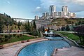
Dikmen Valley Park


Others
Ankara is home to the Turkish Angora , a breed of cats considered the oldest long-haired breed in the world.
literature
- Andreas Birken : The provinces of the Ottoman Empire. Reichert, Wiesbaden 1976, ISBN 3-920153-56-1 .
- Gustav Hirschfeld : Ankyra 1 . In: Paulys Realencyclopadie der classischen Antiquity Science (RE). Volume I, 2, Stuttgart 1894, Col. 2221 f.
- ANḲARA. In: Encyclopaedia of Islam. 2nd Edition. Leiden 1986 ff., ISBN 90-04-08114-3 .
- C. Mostras: Dictionaire géographique de l'Empire Ottoman. St.-Petersburg 1873.
- Clifford Edmund Bosworth: Historic Cities of the Islamic World. Brill, 2007.
- Urs Peschlow: Ankara. The architectural archeological remains from Roman and Byzantine times. With a contribution by Wolfram Brandes . Phoibos Verlag, Vienna 2015, ISBN 978-3-85161-132-8 .
Web links
Individual evidence
- ↑ nufusu.com , accessed February 13, 2020
- ^ Sargon Erdem: Ankara . In: Islam Ansiklopedisi . Volume 3, 1991, p. 202.
- ↑ Franz Taeschner : Ankara . In: The Encyclopaedia of Islam. New Edition . Volume 1, Brill, Leiden, p. 509.
- ^ Sargon Erdem: Ankara. In: Islam Ansiklopedisi. Vol. 3 1991, pp. 201-203.
- ^ Franz Taeschner , A kh ī in: The Encyclopaedia of Islam. New Edition , Vol. 1, Leiden / London 1960, pages 321/323
- ↑ Dr. Ali Cengizkan, translation: Christoph K. Neuman: The foundation of a modern and planned capital for Turkey Ankara 1920–1950. Goethe-Institut Ankara, 2010, accessed on August 11, 2015 .
- ↑ 19 yıllık Ankara amblem savaşı! milliyet.com., January 26, 2014, Retrieved August 11, 2015 .
- ^ Alan Berube, Jesus Leal Trujillo, Tao Ran, and Joseph Parilla: Global Metro Monitor . In: Brookings . January 22, 2015 ( brookings.edu [accessed July 30, 2018]).
- ^ Ankara Metro, Turkey. Retrieved August 11, 2015 .
- ↑ The largest urban cable car in Eurasia is officially opened in Ankara. Leitner ropeways, accessed on September 14, 2016 .
- ^ Ankara Cable Car / Yenimahalle Teleferik (Part 2) «The Gondola Project. Retrieved August 1, 2016 .
- ↑ http://rapor.tuik.gov.tr/reports/rwservlet?adnksdb2&ENVID=adnksdb2Env&report=wa_idari_yapi_10sonrasi.RDF&p_il1=6&p_yil=2012&p_dil=1&desformat=html ( Memento of 13 April 2014 Internet Archive )
- ↑ http://report.tuik.gov.tr/reports/rwservlet?adnksdb2=&ENVID=adnksdb2Env&report=buyukbelediye.RDF&p_il1=6&p_kod=2&p_yil=2010&p_dil=1&desformat=html ( Memento from September 20, 2011 in the Internet archive )
- ↑ a b c İl ve cinsiyete göre il / ilçe merkezi, belde / köy nüfusu ve nüfus yoğunluğu (XLS file). Retrieved September 3, 2014 .
- ↑ TUİK, İl yaş grubu ve cinsiyete göre nüfus. (No longer available online.) 2014, archived from the original on February 13, 2015 ; accessed on February 14, 2015 .
- ↑ TUİK, İkamet edilen ile göre nüfusa kayıtlı olunan il - 2012, Ankara. Archived from the original on May 29, 2014 ; Retrieved September 3, 2014 .
- ↑ Oda Wischmeyer: Paulus: Leben - Umwelt - Werk, UTB, 2012, p. 241
- ↑ Ismail Hakkı Kadı: Ottoman and Dutch Merchants in the Eighteenth Century, BRILL, 2012, p. 31
- ↑ Şenda Kara: Guiding principles and principles for action in modern urban planning in Turkey , LIT Verlag Münster, 2006, page. 156
- ^ Hermann Jansen: Bahçelievler settlement. Goethe-Institut, Ankara, 2010, accessed on August 11, 2015 .
- ↑ Karşıyaka mezarlığı'nın defin alanı 2890 dekara çıkarıldı. (No longer available online.) Archived from the original on October 29, 2013 ; accessed on August 11, 2015 .
- ↑ 2015 Yılı Ziyaretçi Sayıları. In: Anıtkabir Ziyaretçi Sayıları. Anıtkabir Command, accessed August 13, 2016 (Turkish).