Polje
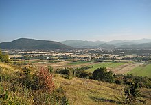
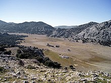
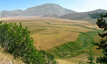
Polje ( Bosnian / Croatian / Serbian / Slovene field , plural: Poljen) is an original term for arable land, taken from the Dinaric Karst , which has been used worldwide as a geomorphological term for a karst hollow form. Since Poljen cannot be identified genetically, they are defined morphographically. Poljen are therefore extensive hollow forms in the karst that are closed on all sides, with mostly flat ground, steep frames in places and clear bends in the slope. They have a subterranean runoff, they can lie dry, they have flow through them all year round or at times or they can be infused . In general, it is kilometer-sized, partly valley-like winding depressions with massive sediment fillings and isolated residual hills, the so-called hum , which are characteristic of some poljes. Their distribution is mostly limited to the humid subtropical karst areas of the Mediterranean ice and tropical cone karst regions, but here in particular in the Caribbean, they are rarely found in temperate karst areas. It is the absolute accumulation and landscape characteristic par excellence for the Dinaric Karst, in which there are over 140 poljes and with the Lika Polje also the largest polje in the world in terms of area.
Poljes can range from a few square kilometers to several hundred square kilometers (e.g. Popovo Polje , Livansko Polje , Gacko Polje ). They are the only hydrological node in the karst hydrological system. This is why ponors always appear in Poljen , and seepage rivers in the larger ones . Two open Poljen in West Balkan are by perennial in lakes, Skutarisee is also a crypto depression.
(Hydro) geology
The karst phenomenon of Polje is not found in all karst areas, however, but depends on the structure of the geological structures, their age and faults, and consequently on the development stage of the karstification processes that form the polje. Examples of impressive size and appearance can be found in the countries of the Dinaric Alps (Slovenia, Croatia, Bosnia-Herzegovina, Montenegro), the Apennines (Italy), Cantabria and Andalusia (Spain) and the Peloponnese.

Geomorphologically, a polje is a trough-shaped depression or hollow form, which - mostly on all sides - is surrounded by steep-walled mountain formations. The formation can develop if (at least) the younger rock layers are carbonate rocks (limestone, dolomite) or gypsum. The bottom of such a basin consists of massive sediment deposits and can be several hundred meters thick. The sediments can be very stony, dry deposits on their surface or loamy / clayey soils - some barren, others very fertile (both even next to each other, near Grahovo ). In numerous poljes of the Dinarides lie moraines, which were formed during the maximum freezing in MIS-12 by local mountain glaciers, which as Piedmont glaciers reached down into individual poljes. The moraines of the Orjen, which descended in Grahovo-Polje and Dragaljsnko Polje, are considered to be significant. Fluvioglacial debris cones reach for kilometers into the poljeboden. Depending on their composition, the sediment layers are water-retaining to water-impermeable. The sole and the delimiting flanks of the Polje, on the other hand, are carbonate rocks , which in geological times were chemically broken down or penetrated by the water of the precipitation and the basin faster than physically (cf. weathering ). In them, increasingly larger openings are formed: cracks, crevices, swallowing holes ( ponors ) and entire cave systems through which the water that collects in the basin can completely drain away. Thus the relief energy remains low, i.e. This means that there is no pronounced surface drainage system ( river erosion ) for the basin . The water-draining openings are mostly right on the edge, on the break edge of a polje, where the sediments meet the mostly steep rock formations. At these break lines, underground water channels are forced to overflow by the damming sediments. These are the places where larger amounts of water emerge than karst springs .
Life and settlement in the Karst


The drainage capacity of the openings fluctuates depending on the (blocked) bottleneck capacity. With above-average or cyclically higher amounts of precipitation and / or blockages due to underground collapses or foreign bodies in the water, poljes become / became temporary lakes for long, short or seasonal cycles. If the soil of a Polje is fertile, it could feed many people. The settlement density is traditionally low, however, as the hydrological control of the Poljen enables an expanding settlement through secure management only with the techniques of the last 100 years. Today, drainage through ditches, artificial drains and widening only allow flooding to occur in extreme cases. Ponors and larger outlets can be provided with settling basins, rakes and funnels in order to stabilize the drainage capacity.
Poljen with one (large), several or many ponors are observed hydrogeologically (Tripoli Plateau, Peloponnese, 40 × 20 km, 47 recorded ponors of various sizes and activities).
Environmental problems in the karst

The aquifers of Poljen and other karst formations are of great importance for the drinking water supply in many European countries. The infiltration of pollutants hazardous to the groundwater must be kept away from them. Poljen populated in the middle or on the edges or with streets crossed (e.g. Benaoján , Sierra de Libar) represent an increased risk of contamination as collecting basins, because their karst environment often has a thin or missing soil cover, high infiltration and flow velocities and therefore a low retention capacity for substances hazardous to groundwater.
Imagery
See also
literature
- A. Morfis (Hrsb): Karst Hydrogeology of the Central and Eastern Peloponnesus (Greece). (= Styrian contributions to hydrogeology ). Springer, Vienna 1986. (English)
Web links
- COST 620 - Hazard mapping for the protection of carbonate (karst) aquifers. ( Memento from May 4, 2007 in the web archive archive.today )
- Annika Wachsmuth: “Karst forms” learning module. In: WEBGEO basics / geomorphology. Institute for Physical Geography (IPG) of the University of Freiburg , p. 8 , accessed on December 14, 2010 .
Individual evidence
- ^ Alfred Bögli: Karst hydrography and physical caveology. Springer, Berlin 1978, pp. 70-73.
- ^ P. Hughe, JC Woodward, P. van Calsteren, L. Thomas, K. Adamson: Pleistocene ice caps on the coastal mountains of the Adriatic Sea. In: Quaternary Science Reviews. 29 (27-28), 2010, pp. 3690-3708.
- ↑ K. Adamson, P. Hughes, J. Woodward: Pleistocene glaciation of the Mediterranean mountains. In: Quaternary Newsletter. 131, 2013, pp. 1-15.
- ↑ cf. the EU research study on groundwater hazards etc. a. the Sierra de Libar in the Spanish province of Málaga , 2003 (see link “Cost 620”).


