
Sierra de Grazalema
| Sierra de Grazalema | ||
|---|---|---|
 Sierra de Grazalema: general map of the natural park |
||
| Highest peak | Torreón ( 1654 msnm ) | |
| location | Cadiz Province , Spain | |
| part of | Betic Cordillera | |
|
||
| Coordinates | 36 ° 46 ′ N , 5 ° 26 ′ W | |
| rock | lime | |

The Sierra de Grazalema is a mountain region and nature park in southwest Spain ( province of Cádiz , Andalusia ). It belongs to the Betic Cordillera and is located in the northeast of the province of Cádiz, a small part extends into the northwest of the province of Málaga . The area became a natural park in 1984 - making it the first natural park in Andalusia.
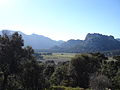
The Sierra de Grazalema is a typical limestone mountain range with numerous karst features ; it reaches a height of 1654 m and, due to its location, is the first hurdle for clouds moving inland from the Atlantic, which rise and rain down here: Grazalema , which is centrally located in the area and gives its name, is the rainiest place in Spain; the area is characterized by a green and rich vegetation that is extraordinary for Andalusia. One of the largest breeding colonies of griffon vultures in Europe lives in the area .
landscape

The Sierra de Grazalema is part of the Ronda mountain range ; the Los Alcornocales Natural Park borders the area in the south . The core and at the same time the highest mountain range is the centrally located Sierra del Pinar , it reaches a height of 1654 m at the summit of the Torreón . It can be seen from afar, for example from Ronda; In the past, it is said to have even served seafarers as a guide when approaching Cádiz . The largest contiguous forest of Pinsapo firs grows on the northern slope of the Sierra del Pinar ( Abies pinsapo Boiss 1838). The Sierra del Pinar is drained by the Río Bocaleones, which forms the Garganta Verde, a gorge up to 400 m deep, which is one of the scenic highlights of the mountains. The largest breeding colony of the griffon vulture is located in the rock walls of this gorge .
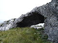
Other mountains are the Sierras del Endrinal and del Caíllo , located south of the Sierra del Pinar ; here is the Salto del Cabrero, one of the landscape landmarks of the region. Both mountains, as well as the Sierra del Líbar in the southeast, are karst landscapes; in the Sierra del Líbar lies the Cueva del Hundidero-Gato , the largest cave complex in Andalusia. This also includes the Cueva de la Pileta with prehistoric rock paintings.
The most important rivers in the area are the Río Guadalete , which flows past Grazalema and feeds the Zahara reservoir, and the Río Majaceite , one of the southernmost trout streams in Europe.
Flora and fauna
In the lower layers the natural vegetation consists of stone and cork oak forests , which are also extensively preserved. Particularly noteworthy from a botanical point of view are the relic forests of the hedgehog or Pinsapo fir endemic here , one of the largest (300 ha) and best preserved of all growing on the northern slope of the Sierra del Pinar. These forests are relics of the coniferous forests, which were widespread in the Tertiary and which have been able to persist in southern Spain at altitudes between 900 and 1800 m on some northern slopes with rainfall over 2000 mm until today; In addition to the Sierra de Grazalema, they are also found in the nearby Sierra de las Nieves Natural Park .
Altogether there are 1279 different species of ferns and flowering plants in the Sierra de Grazalema , which is more than a quarter of all species found in Spain.
The flagship of the area's fauna is the large breeding colony of the griffon vulture, one of the largest in Europe; The Egyptian vulture's nesting sites are also found here . But there are also some species that are rare elsewhere, such as otters , bee-eaters and kingfishers live in and on the Río Majaceite ; in the Sierra del Pinar come ibex before.
History and economy


Human settlement in the area has been documented since the earliest times, for example by paleolithic rock carvings in the Cueva de la Pileta. The first places go back to the Romans , such as the founding of the capital Grazalema; an old Roman road was preserved between Benaocaz and Ubrique . Remains of fortifications, for example in Zahara de la Sierra, testify to the fighting during the Reconquista (reconquest by the Catholic Kings ) .
The economy is characterized on the one hand by pasture farming and on the other hand by small-scale industrial production of leather and leather goods, chairs and blankets. In the 18th century Grazalema was a prosperous town of 9,000 people due to its hydro-powered looms; but lost this role with the industrial revolution - the city was too far from the markets. When it was designated a nature park in 1984, tourism gained in importance. On the one hand, this led to a revival of old traditions, for example a new factory for the production of sheep's cheese was built in Grazalema , a Franco-Andalusian joint venture; on the other hand, numerous hiking trails were marked, which today attract many hikers to this area. The center of leather production is the town of Ubrique in the south of the area.
gallery

Llanos del Ravel
Cueva de las Dos Puertas
Llanos de Líbar

Abies pinsapo

Gyps fulvus


.JPG)


Web links
- Sierra de Grazalema Information on nature and landscape, hiking and tourism in the Sierra de Grazalema
- Official website of the nature park administration (Spanish speaking)
Grazalema (1977) | Ordesa-Viñamala (1977) | Montseny (1978) | Doñana (1980) | Mancha Húmeda (1980) | La Palma (1983) | Marismas del Odiel (1983) | Sierras de Cazorla, Segura y Las Villas (1983) | Urdaibai (1984) | Sierra Nevada (1986) | Cuenca Alta del Río Manzanares (1992) | Lanzarote (1993) | Menorca (1993) | Sierra de las Nieves y su Entorno (1995) | Cape Gata-Nijar (1997) | Bardenas Reales (2000) | El Hierro Island (2000) | Muniellos (2000) | Somiedo (2000) | Redes (2001) | Sierra Morena pasture landscape (2002) | Terras do Miño (2002) | Valle de Laciana (2003) | Monfragüe (2003) | Picos de Europa (2003) | Valle de Jubera, Leza, Cidacos and Alhama (2003) | Babia (2004) | Alto de Bernesga (2005) | Área de Allariz (2005) | Gran Canaria (2005) | Los Argüellos (2005) | Los Valles de Omaña y Luna (2005) | Sierra del Rincon (2005) | Las Sierras de Béjar y Francia (2006) | Los Ancares Leoneses (2006) | Os Ancares Lucenses y Montes de Cervantes, Navia y Becerrea (2006) | Intercontinental Mediterranean Biosphere Reserve (2006) | Rio Eo, Oscos y Terras Buron (2007) | Fuerteventura (2009) | Xurés (2009) | La Gomera (2012) | Las Ubinas – La Mesa (2012) | Mariñas Coruñesas e Terras do Mande (2013) | Terres de l'Ebre (2013) | San Ildefonso – El Espinar (2013) | Meseta Iberica (2015) | Anaga Mountains (2015) | Tagus / Tejo (2016) | Ponga (2018) | Alto Turia (2019) | La Siberia (2019) | Valle del Cabriel (2019)