
Cabo de Gata

Cabo de Gata is a 33,663 hectare area in the province of Almería in southeastern Spain , which is designated as a natural park. The Parque Natural de Cabo de Gata-Níjar begins immediately after the retort ( urbanización) Retamar a few kilometers east of the airport of Almería , stretches across the actual Cabo de Gata (Cape of the agate, not Spanish gato = cat) and ends briefly in front of the port of Carboneras .
location

The coastline of Cabo de Gata is rugged and is bordered by mountains in the hinterland ( Sierra del Cabo de Gata , Sierra de la Higuera ). The geological origin is a strong volcanic activity in the Tertiary, when the Betic Cordillera unfolded. However, all volcanoes have been extinct for millions of years, while the region continues to be affected by earthquakes. Due to the volcanic activity, numerous minerals such as copper pebbles , alkali feldspar , gold, jasper and agate have come to the surface. The highest point in the area is the Pico de los Frailes at 493 meters, an extinct volcano . The Sierra del Cabo de Gata is criss-crossed by dry valleys ( ramblas) and deep gorges ( barrancos). On the beaches between the town of San José and the two capes that give it its name, you can see the lava flows that have flown into the sea. The nature park has very beautiful sandy beaches, which can often only be reached on foot, for example Playa de los Muertos at the northern end of the reserve.
In the western part of the natural park on the Gulf of Almería, the Romans had already set up "salt factories", of which remains can still be seen today. Today's salt pans are further south and offer ideal conditions for a species-rich bird life.
vegetation
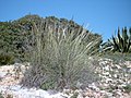
Since the vegetation is unique because of the very warm and dry climate by European standards (2900 hours of sunshine per year), the area has the status of a biosphere reserve . The semi-desert flora of Cabo de Gata is strongly reminiscent of the plant communities on the edge of the Sahara. The characteristic plants include the only palm species native to Europe (besides the Cretan date palm ), the dwarf palm ( Chamaerops humilis), which barely reaches half a meter in height.
Agriculture
Until the 1970s, this region was one of the poorest in Spain. The collecting and processing of the extremely fibrous, flexible and tear-resistant esparto grass was an important source of income for the villages. Two types of grass are distinguished: esparto grass ( Lygeum spartum ) and half grass ( Stipa tenacissima ).

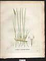
Cabo de Gata snapdragons
Esparto grass
Half grass


Today the grass products are only made for tourists.
Fruit and vegetable cultivation is increasingly being carried out on the plain. The settlement of traditional farms, especially those with an ecological focus, is desirable, even though large areas are covered with tomato plantations directly on the edge of the nature park, the so-called Mar del Plástico, occasionally disregarding the boundaries of the nature park.

Rainfall
With rainfall averaging only 130 to 180 mm, which also falls on only 25 days a year, only very well-adapted plant species can survive.
Use in art
Cabo de Gata is located near the desert of Tabernas , which has been used in several films as a sideshow, so any of these (T) spaceship Surprise and the ruins of the "Planta Denver" -Goldmine and -Hütte in Rodalquilar in one of the Indiana Jones - Movies as well as some desert shots for Lawrence of Arabia .
- In 2007 the German electro band Nova-Spes released the instrumental "Cabo de Gata" on their album Opposite Lane , which describes a journey through the nature park.
- In 2013 the German author Eugen Ruge published his novel Cabo de Gata, Rowohlt Verlag, Reinbek near Hamburg, ISBN 978-3-498-05795-4 .
Web links
- Oficina de Turismo del PN de Cabo de Gata-Níjar (Spanish)
- Cabo de Gata-Níjar Natural Park (Spanish, English)
- Hiking trails in the Cabo de Gata-Níjar Natural Park
- Parque Natural de Cabo de Gata-Níjar , travel information in German on Wikivoyage
swell
- Roberto Cabo: terra nature travel guide Spain. Main destination 30 Cabo de Gata-Níjar, p. 217.
- Guide + Mapa: Cabo de Gata-Níjar.
Grazalema (1977) | Ordesa-Viñamala (1977) | Montseny (1978) | Doñana (1980) | Mancha Húmeda (1980) | La Palma (1983) | Marismas del Odiel (1983) | Sierras de Cazorla, Segura y Las Villas (1983) | Urdaibai (1984) | Sierra Nevada (1986) | Cuenca Alta del Río Manzanares (1992) | Lanzarote (1993) | Menorca (1993) | Sierra de las Nieves y su Entorno (1995) | Cape Gata-Nijar (1997) | Bardenas Reales (2000) | El Hierro Island (2000) | Muniellos (2000) | Somiedo (2000) | Redes (2001) | Sierra Morena pasture landscape (2002) | Terras do Miño (2002) | Valle de Laciana (2003) | Monfragüe (2003) | Picos de Europa (2003) | Valle de Jubera, Leza, Cidacos and Alhama (2003) | Babia (2004) | Alto de Bernesga (2005) | Área de Allariz (2005) | Gran Canaria (2005) | Los Argüellos (2005) | Los Valles de Omaña y Luna (2005) | Sierra del Rincon (2005) | Las Sierras de Béjar y Francia (2006) | Los Ancares Leoneses (2006) | Os Ancares Lucenses y Montes de Cervantes, Navia y Becerrea (2006) | Intercontinental Mediterranean Biosphere Reserve (2006) | Rio Eo, Oscos y Terras Buron (2007) | Fuerteventura (2009) | Xurés (2009) | La Gomera (2012) | Las Ubinas – La Mesa (2012) | Mariñas Coruñesas e Terras do Mande (2013) | Terres de l'Ebre (2013) | San Ildefonso – El Espinar (2013) | Meseta Iberica (2015) | Anaga Mountains (2015) | Tagus / Tejo (2016) | Ponga (2018) | Alto Turia (2019) | La Siberia (2019) | Valle del Cabriel (2019)
Coordinates: 36 ° 51 ′ 0 ″ N , 2 ° 6 ′ 0 ″ W.