
Anaga mountains
| Anaga mountains | |
|---|---|
 Location of the Anaga Mountains in Tenerife |
|
 Laurel forest in the Anaga Mountains |
|
| Highest peak | Cruz de Taborno ( 1024 m ) |
| location | Tenerife , Spain |
| Coordinates | 28 ° 32 ′ N , 16 ° 16 ′ W |
| Age of the rock | 7-9 mya |
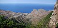
The Anaga Mountains ( Spanish : Macizo de Anaga ) is a mountain range in the Canary Islands and is located in the northeast of Tenerife . The mountains were formed by volcanic activity around 7 to 9 million years ago. It is 20 km long in a west-east direction and extends from north to south in a width of 5 to 10 km. The mountains were formed by volcanic activity seven to nine million years ago. The highest points are the Cruz de Taborno with 1024 m height in the west of the mountains and the Chinobre with 909 m in the east. The crest of the massif, which forms the wettest region on the island due to fog and rain, is overgrown with laurel forest.
In 1987 a nature park was founded, which in 1994 was given special protection as Parque Rural de Anaga . The largest town in the Anaga Mountains with around 700 inhabitants is Taganana , which is located in a wide valley not far from the Atlantic coast. The area has also been a biosphere reserve since 2015 .
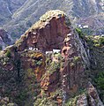
Typical of the Anaga are the caves in the volcanic rock, whose facades and interior fittings are similar to those of local single-family houses, for example in Afur and Chinamada . The mountains are rich in legends about witches and covens .
tourism
The Anaga Mountains are easily accessible to tourists by a road over the ridge. Numerous hiking trails and forest roads branch off from it, making various viewpoints and all areas of the forest accessible. The Anaga Mountains are a destination for hikers and nature tourists. The meter-high surf on the steep and rocky north coast is also a natural spectacle. The rocks at Almaciga and Las Palmas de Tenerife, especially the Roque de Anaga and the Roque Bermejo as well as the Playa del Benijo beach, are popular photo opportunities. The Roque de Anaga forms the northernmost tip of the island of Tenerife. The hike from Punta del Hidalgo at the foot of the Anaga Mountains to the cave village of Chinamada is also popular .
gallery
The village of Taganana in the Anaga Mountains, near the Mirador (viewpoint) El Bailadero
Dwelling caves in Afur

San Andrés Castle

Laurel cloud forest

Terraced fields in Chinamada


literature
- Baedeker: Tenerife , Verlag Karl Baedeker , ISBN 3-87504-232-8
- Rother hiking guide: Tenerife , Bergverlag Rother , ISBN 978-3-7633-4016-3
Web links
- Arrival information for tourists (German)
- The settlers of the Anaga Mountains - history
Individual evidence
- ↑ Tenerife - Anaga Mountains. July 4, 2015, accessed on March 15, 2019 (German).
- ↑ El macizo de Anaga alberga mayor concentración de endemismos de toda Europa
- ↑ Guía de Anaga ( Memento of the original from August 10, 2011 in the Internet Archive ) Info: The archive link was automatically inserted and not yet checked. Please check the original and archive link according to the instructions and then remove this notice. (PDF file; 2.06 MB)