
El Hierro
| El Hierro | |
|---|---|
 
|
|

|
|
| Location of Hierro within the Canary Islands | |
 |
|
| Basic data | |
| Country: |
|
| Archipelago: | Canary Islands |
| Province: | Santa Cruz de Tenerife Province |
| Geographical location: | 27 ° 44 ′ N , 18 ° 3 ′ W |
| Surface: | 268.71 km² |
| Residents: | 10,968 (2019) |
| Population density: | 39.74 inhabitants / km² |
| Capital: | Valverde |
| President of the island government: | Alpidio Armas ( PSC-PSOE ) |
| Website: | Island government |
| Satellite image | |

|
|
El Hierro [ elˈjero ], former name Ferro , is the westernmost of the Canary Islands in the Atlantic Ocean . It belongs to the Spanish province of Santa Cruz de Tenerife . With a 3.59 percent share of the archipelago's land area, it is the smallest of the seven traditional main islands. El Hierro is 1,458 kilometers from the Spanish mainland ( Cadiz ), has an area of 268.71 km² and 10,968 inhabitants (January 1, 2019), which corresponds to a population density of 39.74 inhabitants / km². El Hierro was declared a Biosphere Reserve by UNESCO in 2000 .
administration

El Hierro belongs to the Spanish province of Santa Cruz de Tenerife in the Spanish Autonomous Community of Canary Islands, which has been in existence since 1982, and has been part of the EU since 1986 . The capital of the island is Villa de Valverde in the municipality of Valverde , the national language is Spanish .
El Hierro has its own island council, the Cabildo Insular , and has been divided into three municipalities, each with its own town hall, since September 15, 2007: Valverde , La Frontera and El Pinar . These are members of the Federation of Canary Islands municipalities, Federación Canaria de Municipios (FECAM) . Alpidio Armas González was appointed President of the Island Council of El Hierro by the PSOE in 2019.
Between 1913 and 2007 the island was only divided into the two municipalities of Valverde and La Frontera. After the first efforts to outsource El Pinar from La Frontera arose in October 2006, El Pinar finally became independent in September 2007, making it the third municipality on the island.
- Presidents of the Island Administration
| No. | Surname | Beginning | The End | Political party |
|---|---|---|---|---|
| 1. | Tomás Padrón Hernández | 1979 | 1991 | Agrupación Herreña Independiente (AHI) - Coalición Canaria (CC) |
| 2. | Venancio Acosta Padrón | 1991 | 1991 | AHI - CC |
| 3. | Inocencio Hernández González | 1991 | 1995 | Partido Socialista Obrero Español (PSOE) |
| 4th | Tomás Padrón Hernández | 1995 | 2011 | AHI - CC |
| 5. | Belén Allende Riera | May 2011 | September 2011 | AHI - CC |
| 6th | Alpidio Armas González | September 2011 | 2015 | independent |
| 7th | Belén Allende Riera | 2015 | 2019 | AHI - CC |
| 8th. | Alpidio Armas González | 2019 | til today | Partido Socialista Obrero Español (PSOE) |
history
First settlement
Phoenician seafarers were believed to have been around at the beginning of the first millennium BC. The first people to reach the Canary Islands. Archaeological finds show that the first settlements were established there at this time. In the following period there were economic connections to the Mediterranean area. At the latest in the 3rd century BC BC people from the area north and south of the Strait of Gibraltar were settled in the Canary Islands. On some islands archaeologists found remains of salt pans and a production facility for purple from the 1st century BC. The colonization process was not the same on all islands. The oldest proven finds on El Hierro in the Cueva de La Lajura date from the 2nd century AD.
Time of isolated development
The presence of Roman or Romanized seafarers on the entire island group, as evidenced by archaeological finds, ended in the 3rd century AD at the same time as the crisis of the Roman Empire . Since the Bimbaches , the indigenous people of the island of El Hierro, had neither tools for building seaworthy ships nor nautical knowledge, there were no connections to the inhabitants of the other Canary Islands. In the following 1000 years up to the 14th century, El Hierro developed its own culture of the Bimbaches.
Submission of the natives by Europeans
Ever since European seafarers and traders were able to easily cover the sea route to and from the Canary Islands in the middle of the 14th century, there have been repeated attacks on the indigenous people, who were captured and sold as slaves in the Mediterranean region and on the Iberian Peninsula. In 1393 an expedition caught large numbers of islanders; among them was Augerón, a brother of the king of the island. Shortly before the arrival of the French Jean de Béthencourt , 400 people are said to have been caught in another expedition. In 1405 Jean de Béthencourt landed on behalf of the Castilian King Henry III. in the south of El Hierro in the Bahía de Naos . In the chronicle " Le Canarien ", among other things, the diplomatic and military approach in the submission of the Bimbaches is presented. A brother of King Armiche, whom Jean de Béthencourt had bought at the slave market in Aragon, served as an intermediary. The king was assured of safe conduct to the talks. When he then met with Jean de Béthencourt, he had him and his 111 companions arrested and sold as slaves. 120 French settlers were settled on the island. This dishonest act is excused in Le Canarien with the fact that in this way the resistance on the island could be broken without fighting.
Developed under the rule of the Crown of Castile
After the subjugation of the population of the islands of Lanzarote, Fuerteventura and El Hierro and unsuccessful attempts to conquer other islands, Jean de Béthencourt left the Canary Islands in December 1405 and entrusted his relative Maciot de Béthencourt with the rule. On November 15, 1418 Maciot de Béthencourt irrevocably transferred the lordship rights to the Canary Islands in the name of Jean de Béthencourt to the Count of Niebla, Enrique de Guzmán. The count confirmed Maciot de Béthencourt as captain and governor of the islands. In the years that followed, ownership of the Canary Islands was repeatedly passed on to other feudal men of the King of Castile through gifts, purchases and inheritance. After the fiefdom of the island of El Hierro passed to Hernán Peraza (El Viejo), Hernán Peraza (El Viejo) re-conquered the island with the help of 300 men from the islands of Lanzarote and Fuerteventura. The Bimbaches had to surrender and were then all, if they weren't already baptized. In 1452 Inés Peraza de las Casas and her husband Diego García de Herrera y Ayala inherited the rulership rights on the island of El Hierro. Under the rule of the Peraza-Herrera family , new colonists from Castile were settled. A report from 1632 found that while there were still indigenous people, the language had disappeared since the beginning of the 17th century.
Christoph Columbus
On his second trip to La Gomera , Christopher Columbus also drove to El Hierro to load fresh water and food. He also wanted to wait for a favorable wind that would let his fleet of 17 ships move westward quickly. After 19 days on El Hierro, on October 3, 1493, a powerful trade wind finally blew it from the Bahía de Naos into the New World .
Former prime meridian

In ancient times, the Canary Islands were considered the western end of the world. Claudius Ptolemy therefore established the meridian running through the Canary Islands as the prime meridian around 150 . This definition was later specified on the westernmost island of El Hierro. The Ferro-Meridian was created , according to which the geographic coordinates of numerous navigation and maps from the 16th to the 19th century were based. This means that the island was popularly known as Isla del Meridiano or Isla del Meridiano Cero . It was not until 1884 that the Greenwich meridian was established internationally as the prime meridian that its importance began to wane.
Island of exile
In the 19th century El Hierro became interesting for Madrid . Inconvenient politicians, the military and free spirits were banished to this island. The islanders also benefited from it, because Leandro Pérez , banned for political reasons, was the first medicin on the island. He was respected by the population.
Way to modern times
In July 1899 a major fire destroyed the town hall of Valverde and the archives on the island, which had been kept since 1553. Many important documents about the history of the island have been irretrievably lost. Around this time an epidemic of smallpox broke out and a long drought followed heavy torrents. In 1912 the two municipalities of Valverde and La Frontera were created . Every island, including El Hierro, has since been allowed to administer itself. The Cabildo Insular , the island government, was established. The First World War passed the island without a trace. During the Second Republic (1931–1936) the port was expanded, roads rebuilt, the water supply improved and schools expanded. Even the Second World War brought El Hierro little harm in contrast to the other islands.
emigration
The various waves of emigration were due to political crises and years of drought and famine. Destinations included Cuba , Venezuela and Puerto Rico . As recently as 1949/1950, sailing ships that were hardly suitable for the high seas without engines set sail from El Hierro to cross the Atlantic. Some emigrants returned later.
In 1948 another drought forced large numbers of residents to emigrate. The wells on the island had dried up, agricultural products withered, cows and sheep died. Don Tadeo Casañas on Hierro noticed one night that water was dripping through the leaky roof, the bushes on his roof had condensed the mist into water. He remembered stories about the indigenous people on Hierro who caught water on their sacred tree, the Garoé, that had condensed from the mist. Tadeo told his neighbors to put shrubs or plates on their roofs to "milk" water from the fog. He saved his neighbors from dying of thirst.
Civil missile base and military radar system
In the 1990s there were plans by the Spanish government and the autonomous government of the Canary Islands to install a civil missile base on the island. The European Space Agency (ESA) in Paris planned to send about two research satellites into space per year, but there are also said to have been plans for up to 15 launches. For safety reasons, one would even have had to evacuate neighboring villages at the time of the start. All of this resulted in massive protests from the islanders. They wanted to protect the unique nature and their environment. In February 1997, a special committee of the Canarian Parliament rejected the entire project with the approval of its members.
A further plan to install a military radar early warning system on the summit of Malpaso for anti- aircraft defense has not yet been decided. The geographic location of the island is the reason. There have been violent popular protests since 1986 when the Spanish Ministry of Defense first presented its plans to the La Frontera municipal administration. In June 2005, the then Spanish Defense Minister José Bono announced that he could also imagine a mobile, non-permanently installed system that would also be suitable for other purposes. Of the 70,000 m² site planned at the beginning, only 3,500 m² would be needed today; but also new access routes. These would cross the historic path to the chapel of the island saint and patron saint (Santuario de Nuestra Señora de los Reyes) , which is unthinkable and untenable for the Herreños. The rejection of the islanders remains unbroken. There are also protests on other islands such as Tenerife.
geology
Structure and creation of the island

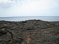
Like all the Canary Islands, El Hierro is of volcanic origin. The island is the youngest in the archipelago, around 1.12 million years old. In contrast to most of the other Canary Islands, which have a three-phase history, El Hierro is still in the first of these three phases, that of the shield volcano (see: Canary Islands ). When the magma tore up the sea floor, cracks in the shape of a Y-shaped line opened up. Later eruptions peaked around 10,000 BC. The most recent eruptions lasted from 4000 BC. BC to the first millennium AD and were of rather modest proportions compared to the old ones. The island gradually formed along the axis of the Y-shaped rail. The resulting lava masses mainly cover the coastal areas in the south and west, but also partly in the north. They flowed down the ancient slopes and increased the area of the island. The only documented eruption, accompanied by earthquakes, was last in 1793 that of the Lomo Negro near Playa Verodal .
Creation of the El Golfo valley

The current shape of the island is essentially due to several landslide events, the rubble fans of which can be detected in the sea around El Hierro. In the south-west, for example, the flank of El Julan fell into the sea about 160,000 years ago.
The El Golfo valley in the north-west of the island also has the semicircular shape of an amphitheater , which was probably created by two landslides and debris avalanches 130,000 and 15,000 years ago. The previous 2,000 m high volcanic building, with its center in the area of today's Frontera, lost a visible volume of 120 km³ and again the same amount of submarine material.
Large tsunamis with effects on the entire Canary Islands and beyond were probably the result of these landslide events.
While the steep trailing edges still show the old rock of the previous volcano , the valley floor was partially refilled with lava from younger cinder cones (e.g. Tanganasoga , 1,364 m). Today the soil in the Golfo Valley is fertile and the climate favorable for cultivated landscapes.
Geological activity from 2011 and submarine eruption


Since July 17, 2011, there has been an accumulation of small earthquakes, so-called swarmquakes , which initially had their epicenter on Tanganasoga in the El Golfo valley , but later shifted further south off the coast. Within the following months around 12,000 earthquakes with a magnitude of 2.0 or more on the Richter scale were registered, but the majority were not noticeable to humans. The quakes came from about ten to fourteen kilometers deep. The middle of the island had risen by about 3.5 centimeters, and more carbon dioxide (CO 2 ) was released.
After the strongest earthquake to date, with a magnitude of 4.3, occurred on October 8, 2011, the earthquakes changed to a continuous volcanic tremor on October 10 . This and other data led to the conclusion that a submarine eruption had started five to seven kilometers off the south coast of El Hierro at a depth of about one kilometer. On October 11th, the village of La Restinga , which is located on the southern tip of the island directly by the sea, was evacuated and the area red alerted.
On October 12, 2011, visible signs of the submarine eruption appeared for the first time, in particular brown to greenish discoloration of the sea surface, evidence of two new eruption sites about 2.5 kilometers off the coast at a depth of 500 and 750 meters respectively. Gas bubbles and steaming lava fragments on the surface of the water indicated from October 15 that the depth of the eruption had decreased to 150 meters.
The submarine eruption of the basaltic type off La Restinga lasted several months with a gradual weakening, with intermittent flooding of lava fragments, steam and sea discoloration, with the strongest earthquake with a magnitude of 4.6 on November 11, 2011. On March 6th In 2012 the eruption was officially declared over. Bathymetric measurements showed that up eruption end along a straight line extending in the NW-SSO-direction column at least 4 vents were formed, whose highest point was 89 meters below the water surface.
Even after the submarine eruption ended, there were several phases of increased seismic activity in the island area. In June / July 2012 hundreds of weaker earthquakes were registered again, most of which had their origin at a depth of around 15 kilometers and this time near the west coast of the island community of El Pinar. There were further more pronounced phases in June and September 2012, December / January 2012/13, March / April 2013 and December 2013 (with a magnitude of 5.1 on December 27, with the island being raised by 6 to 8 cm). They followed a characteristic pattern with a gradual increase in the number and intensity of the quake over several days, finally culminating in quakes that were felt across the island. In all cases, they were associated with significant deformations of the island surface, which indicate magma deposits at depth.
Coat of arms and symbols
coat of arms
The coat of arms shows the castle and the lion on a blue background, which symbolize the bond with Castile , while the golden crown refers to the Count of La Gomera , who was also lord of El Hierro. The tree with a cloud in its crown and a pool of water at its base is the Garoé , the sacred tree of the indigenous people. With its foliage, it condenses water from the mist, which drips off and thus provides the natives with drinking water.
Symbols of nature
Symbols of the nature of the island of El Hierro are the El Hierro giant lizard and the Phoenician juniper .


Landforms

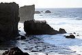
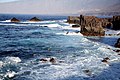
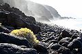
In contrast to the neighboring islands, El Hierro is barely divided by gorges (barrancos) , except in the northeast . The Cumbre , the wooded summit region of the volcanic mountains, stretches across the island . Roughly one can determine the three landscape forms of the wide plateau in the northeast, the El Golfo valley in the northwest and the sloping area of El Julán in the southwest. There are great contrasts: On the one hand, El Hierro is very high in relation to the area (up to 1500 m above sea level) and therefore has steep cliffs for 90 percent (more than 100 km) of the coastline, on the other hand it has a gently undulating, fertile highlands that are unique in the Canarian archipelago. It is used intensively for agriculture.
There are no flat coastal areas, with the exception of the golf valley. Despite its small size, El Hierro offers a considerable variety of landscapes, such as barren lava desert , cloud forest, pine forests, fruit groves, green pastureland up to pineapple and banana plantations. To the south is the Cueva de Don Justo , the largest cave on the island. It consists of a widely branched system of lava tunnels. These occur when the outer skin of the lava has already cooled down and remains standing, but inside the lava continues to flow. There are also many volcanic caves on El Hierro that were created by gas bubbles or lava channels. Some of them already served the Bimbaches as accommodation or graves.
The plateau
On the formerly heavily forested plateau, deforestation, forest fires, erosion and pasture farming have created many bare areas. On the other hand, irrigation has also created fruit plantations and fields. There is no major stream on the island. Rainwater only runs from the rocks from a few sparse springs.
The southwest
In the southwest, at 'El Julán' and the high pastures of Dehesa , a large area with a gradient of up to 45 percent extends from the 1400 meter high Cumbre down to 100 meters. The rest is cliffs. On the lower part of the area, the sun burns down on rock with no vegetation. In the far west there was once an extensive juniper forest , of which only a few old specimens of the Sabinas defy the wind.
- Landforms:

Pine forest
Punta de Arenas Blancas, cliff
El Golfo, coast

La Dehesa
Charco Azul, cliff

Los Toscones

Bahia de las Calcosas
Arenas Blancas, lava formation


climate
.jpg)
The Passat in particular determines the weather. It is thanks to him and the Canary Current, a cool tributary of the Gulf Stream that separates from it at the Azores , that El Hierro does not have an arid climate like the Sahara at the same northern latitude. The sea temperature of 18 ° C in winter and just over 20 ° C in summer moderates the climate on the coasts. The northeast trade wind is the product of the low-pressure gully created by the intense solar radiation of the equatorial belt (10 ° S to 10 ° N). This, in turn, results from the heated air masses that rise up to the tropopause and flow northwards in the northern hemisphere, where they cool down due to the altitude and consequently sink to around the geographical latitude of 20 ° to 30 ° N ( subtropical high pressure belt ) and from there again on the ground flow south back to the equatorial depression. The Coriolis force causes these air masses in the northern hemisphere to be deflected clockwise, i.e. to the west. Therefore the northeast trade wind is the predominant wind. Coming from there, the sea-moist air stream has to overcome El Hierro's mountains and therefore preferably rains on the northeast side of the island. The clouds no longer arrive on the southwest side of the island because they have rained down or evaporated. The air warms up above the land mass, which is why the southwest is very dry and hot.
In summer the temperature in the north on the coast is 26 ° C, in the south it is 30 ° C; in Valverde at 600 m above sea level. d. M. in summer only at 18 ° C. In winter it is around 20 ° C cool on the coast in the north and around 1.5 ° C warmer in the south. In Valverde, on the other hand, temperatures only reach 11.5 ° C in winter. Average values are always given. In Valverde, precipitation falls 80 mm per month in winter and only 25 mm in the south. In summer there is usually no precipitation in the south, but in Valverde 5 mm per month is still possible.
| El Hierro (place unnamed) | ||||||||||||||||||||||||||||||||||||||||||||||||
|---|---|---|---|---|---|---|---|---|---|---|---|---|---|---|---|---|---|---|---|---|---|---|---|---|---|---|---|---|---|---|---|---|---|---|---|---|---|---|---|---|---|---|---|---|---|---|---|---|
| Climate diagram | ||||||||||||||||||||||||||||||||||||||||||||||||
| ||||||||||||||||||||||||||||||||||||||||||||||||
|
Average monthly temperatures and rainfall for El Hierro (location not named)
Source: wetterkontor.de
|
|||||||||||||||||||||||||||||||||||||||||||||||||||||||||||||||||||||||||||||||||||||||||||||||||||||||||||||||||||||||||||||||||||||||||||||||||||||||||||||||||||||||||||||||||||||||||||||||||||
flora
Although El Hierro is influenced by the northeast trade winds , the vegetation is not as lush as on the green neighboring islands of La Palma, Tenerife or La Gomera. The reason is that large parts of the island are covered with even younger lava, and that extensive clearing of the once dense forests was followed by erosion. But there is still great biodiversity and some endemics . Good examples are the living fossils such as the Canarian Dragon Tree and some ferns . Fossilized finds indicate that these plants are the descendants of a species from the Mediterranean basin that existed there about a million years ago. There they died out in the Quaternary , during the last Ice Age, but they were able to survive in the unchanging Atlantic climate. Other plant species still have relatives in the Mediterranean area or on the mainland in Europe, but they have developed differently due to the isolation of the islands. About 150 Canary Islands endangered species live on El Hierro, of which eleven species only occur on El Hierro. These are types of thick-leaf plants , lichens , thistles and adder heads that usually grow in the many crevices in the rock.
The altitude is decisive for the occurrence of the plant species. There is the dry coast up to about 400 m above sea level. d. M., above it up to about 800 meters the semi-humid area, and finally up to the summit at 1500 meters the foggy area.
Arid coastal areas
On the dry coasts the plants live almost exclusively from the nocturnal dew, which is why the succulents , the water-storing species , thrive here . This also includes the widespread milkweed family (Canarian: tabaiba ). The milky juice of balsam spurge ( Euphorbia balsamifera , also tabaiba dulce ) was once used by shepherds as a thirst-quenching chewing gum. In contrast, the juice of column euphorbie or candelabra wolf's milk ( Euphorbia canariensis , Spanish: cardón ) served the guanches as a chemical club when fishing. It grows on El Hierro mainly on the steep walls of Las Playas , hence the name of the southern area of the place: Los Cardones . The moon damper bush ( Rumex lunaria ) can also be found in the dry zone of the coast . The goats especially like it. The spicy, fragrant Canary Island wormwood ( Artemisia thuscula ), which forms dense and low bushes, is also common. In salty air on the seafront of flourish comb-shaped beach Lilac ( Limonium pectinatum ) and the soda plant ( Mesembryanthenum crystallinum ), also called ice plant or ice plant. This converts the salt from the air into soda , which is why it was exported to Europe for soap production on the larger islands in the 19th century .
Semi-humid zone

In this zone, which is about 200 to 400 m above sea level. d. M. begins, succulents also settle . In addition to various thick-leaf plants such as aichryson , cacti and agaves also thrive here . The endemics of the genus Aeonium on El Hierro are Aeonium hierrense and Aeonium valverdense . The pinnate-leaved goose thistle ( endemic representative: Sonchus hierrensis ) and the thyme- scented small shrubs of the gray mountain mint endemic to El Hierro ( Micromeria hierrensis ), a relative of the savory , also thrive in this zone . There is also an island endemic among the purple or blue flowering adder head species ( Echium ): Echium hierrensis . The seed of the hairy bizarre ( Bidens pilosa ) hangs like burdock on the hiker's trouser legs. The locals call it amor seco (dry love). Brought back by immigrants from Central and South America, Opuntia ficus-indica , tree tobacco ( Nicotiana glauca ) and sisal agave ( Agave sisalana ) thrive on the island. Opuntia were brought from Mexico as early as the 16th century . They covered large areas of the island, as they were economically very valuable for the production of dye from cochineal . The Herreño sometimes uses the fruits of the opuntia as fodder for cattle. In the semi-humid so-called Montan stage, the dragon tree and the Canary Island date palm ( Phoenix canariensis ) also grows the island's symbol: the Phoenician juniper ( Juniperus phoenicea ssp. Canariensis ). You can find them as an inconspicuous bush or in the far west of El Hierro as trees several hundred years old, bizarrely shaped by the constant wind. It is only the remains of an extensive Sabina forest.
Fog-damp zone

Here, at an altitude of 800 to 1500 m above sea level. d. M., is El Hierro's evergreen wet forest, the Monteverde , with moisture-loving plants such as the laurel trees . The largest contiguous forests of these trees exist on the neighboring islands of La Palma and La Gomera. On El Hierro there are only smaller clusters, some mixed with pine trees . The stink laurel ( Ocotea foetens ) also grows there . The white flowering Mocán ( Visnea mocanera ) as well as the olive tree ( Picconia excelsa ) and the Canary strawberry tree ( Arbutus canariensis ) thrive in clearings . In the past, these three tree species formed entire forests on El Hierro. The cedar juniper ( Juniperus cedrus ) up to 25 meters high can also be found here and there. The cloud forest on El Hierro, mixed with laurel and a few pines, consists mainly of tree heather ( Erica arborea ) and gale tree ( Myrica faya ). This forest is also known as the Fayal Brezal Forest . Ferns also grow in the primeval jungle . The rooting chain fern ( Woodwardia radicans ) has up to three meters long fronds. The maidenhair fern ( Adiantum capillus-veneris ), the bracken ( Pteridium aquilinum ) and the Canary worm fern ( Dryopteris oligodonta ) also live here . The Bimbaches were able to produce flour from the bracken roots, the forerunner of Gofio . Other plants in this zone are the Canarian St. John's wort, up to two meters high , the asphalt clover ( Psoralea bituminosa ), the gorse- like codeso ( Adenocarpus foliolosus ) and the sprouting dwarf gorse ( Chamaecytisus proliferus ). There is also the up to 40 meters high, from Australia introduced eucalyptus tree ( Eucalyptus globulus ). It draws a relatively large amount of water from the soil and can therefore damage other plants in the area. That is why it is no longer grown today.
.jpg)
In the interior of the island, north of San Andrés at about 1000 m above sea level. d. M., there is another symbol of the island, the Garoé ( arbol santo ), the sacred tree of the indigenous people . It is a stink laurel , already mentioned , which was replanted in 1957. The sacred original tree - it was a specimen of the Tilo laurel tree - is said to have felled by a storm in 1610. The tree was used and revered by the indigenous people (Bimbaches) as a water dispenser (through fog condensation ), as the island had few water resources. However, the productivity of this process is very limited. When the conquistadors took possession of the island, the Bimbaches decided to keep the hiding place of the sacred tree a secret. They did it in the hope that the conquerors would leave the island again as they found no rivers or springs.
The inclusion of the sacred tree in the island's coat of arms illustrates its historical importance (see section Coat of Arms).
fauna
Reptiles


Lizards are particularly common on El Hierro, such as the endemic striped Canary Island gecko ( Tarentola boettgeri ). The most common type of lizards ( lagartos ) is the Boettger's Lizard ( Gallotia caesaris ) with up to 35 cm length. Often you can also see the blindworm-like canary skink ( Chalcides coeruleopunctatus ) with stubby legs, which is why it is sometimes mistaken for a snake. However, there is no species of snake in the Canaries. The loggerhead sea turtle ( Caretta caretta ), the largest reptile in the archipelago , still lives in the coastal waters .
Lagarto gigante
El Hierro is known for a large prehistoric species of lizard, the El Hierro giant lizard ( Gallotia simonyi ) or in Spanish: Lagarto gigante . Except for the human who began to hunt and eat her, she had no enemies. At the time of the Spanish conquest in the 15th century, the population decreased dramatically due to the cultivation of many areas of land. Sheep and goats also contested the lizards for food. They only survived on the Roque Chico de Salmor, the smaller of the offshore rocky islands in the northern El Golfo Valley (in German the small Salmor rock), where they were rediscovered at the end of the 18th century. In a scientific treatise from 1889, the lizards were given the nickname simonyi , after the geologist and Canary Islands researcher Oscar Simonyi . The few lizards that were discovered were caught and resold stuffed, so that they were once again considered to be extinct. But in the 1970s a goatherd accidentally discovered some specimens of large lizards on the steep face of Fuga de Gorreta . It was believed that survivors could have escaped there, but it was only a subspecies of the Lagarto gigante . They are called Gallotia simonyi machadori . This small population has been under nature protection since 1975 . Since 1996 some can be admired in the Lagartario , in the museum village of Guinea . The Lagarto gigante becomes up to 75 cm long, has an anthracite-colored scale armor with a light pattern, and a strong, compact shape. It has a long thin tail, long toes, and feeds on plants and insects. The mating season is in May, one month later up to twelve eggs are laid, from which the young hatch eight weeks later. In 2007 60 young animals were born, so this year a total of around 200 specimens are recorded. You don't know how old the lizards get, because none in the Lagartario is over 37 years old (as of 2007). The island government decided at the end of 2007 to build a new terrarium. The project, which costs around one million euros, is financed one third by El Hierro and two thirds by the Canary Islands government. The first construction phase, which is quoted as having a cost of € 300,000, was completed in 2012. These are the total of 22 pools in the open-air enclosure with a fence and a container for the staff or the monitoring of the facility.
Birds
Some bird species are represented on El Hierro with special subspecies, such as the chaffinch ( Fringilla coelebs ombriosa ) and the African blue tit ( Cyanistes teneriffae ombriosus , “Hierroblaumeise”). There is also the Canary Girlitz ( Serinus canarius ), which cannot keep up with its bred yellow comrades in Europe's cages, the canaries , in terms of song and color. But can sing beautifully, the blackcap ( Sylvia atricapilla heineken ). Otherwise there are sparrows , blackbirds , robins , wrens , goldfinches and the hoopoe on El Hierro . The Canary Chiffchaff ( Phylloscopus canariensis ) and the Canary Pipit ( Anthus berthelothii ), also called wanderers, are also common.
Some species of crows and common ravens ( Corvus corax ) also feel at home next to lovebirds and Canarian rock pigeon ( Columba livia canariensis ). Critically endangered ospreys nest on some cliffs. There are also falcons , sparrowhawks , the red kite and a Canary Islands endemic subspecies of the buzzard ( Buteo buteo insularum ). Then there are the Canary Long- eared Owls ( Asio otus canariensis ) and the Barn Owls ( Tyto alba gracilirostris ). Rock partridge and quail are plentiful on the island. Not to forget the Mediterranean seagull, which can be found not only on the coasts but also frequently on the pastures of the Nisdafe plateau.
insects
There are around 5000 species of insects on the island, including numerous butterflies , such as the large monarch butterfly ( Danaus plexippus ), the Canary Islands endemic admiral ( Vanessa vulcania ) and the velvet butterfly Hipparchia bacchus, which is endemic to this island . There are also some moths . Domestic animals among the insects are the bees introduced by humans . Their relatives, the bumblebees , are endemic and have a white rump here. The ladybug is a little bigger on El Hierro and is called San Antonio . It is not uncommon to see dragonflies . Both large and small grasshoppers are worth mentioning, but a nuisance . In the 1950s, voracious swarms came from Africa , which are hardly a threat today, as they are already being treated with insecticides at sea .
traffic

With its island airport , El Hierro is connected to the neighboring islands of Gran Canaria and Tenerife ( Tenerife North Airport ) by direct connections from the airline Binter Canarias .
There have been regular passenger ferry connections since the early 1990s. The most important island port, in which the passenger ferries also dock, is Puerto de La Estaca on the east coast, about seven kilometers from the island's capital Valverde. Since March 2014 a catamaran of the shipping company Naviera Armas has been connecting El Hierro with Los Cristianos in the south-west of Tenerife. In 1960 El Hierro's port of Puerto de la Estaca was the only connection to the rest of the world. Until then, a mail ship only docked here once a week. The name of the island harbor has its origins in the time when sailing boats had to be moored to an iron rod attached to the rock, the estaca . Larger ships still had to anchor in the sea because the pier was too short for the entrance. Small boats then brought the cargo ashore.
The airport and ferry port on El Hierro can be easily reached by bus or taxi. Today the most important roads on the island are well developed, so that almost every place can be reached without any problems. For example, on August 25, 2003, the almost three kilometer long road tunnel between Mocanal near the capital Valverde and the El Golfo valley was opened, so that this route has been considerably shortened.
power supply

Until 2015 the island was only supplied with electricity from diesel generators. These have an output of 13.6 megawatts. In 2011 they produced a total of 44.6 GWh, for which 9812 tons of diesel were required, the costs for this totaled 10.8 million euros. The peak electricity demand of El Hierro in 2011 was 7.56 megawatts.
The “Gorona del Viento (GdV)” wind power plant was supposed to make the island independent of fossil fuels. Five wind turbines of type E-70 with a total of 11.5 megawatts were erected on a ridge to the northeast of the island. In addition, a 380,000 cubic meter upper water basin was built to store water for irrigation purposes and for the pumped storage power plant. If there is excess wind energy, water can be pumped 655 meters higher from the 150,000 cubic meter lower basin at sea level. If necessary, the water in the upper basin can contribute to energy generation by means of water turbines . The cost of the project was 85 million euros.
The electricity production should also meet the demand for the seawater desalination plants and electric vehicles. The energy supply from renewable energies should be 23 percent cheaper than the previous electricity supply with diesel generators.
In the meantime it has turned out that the combination installed on El Hierro is not sufficient to supply the island exclusively with renewable energies. According to calculations, 17 megawatts of wind generator output would have to be installed instead of 11.5 megawatts, and the pumped storage plant would have to be able to accommodate twenty times the originally planned storage volume. The published information shows that, for reasons of network stability, the diesel generators continued to run even at times with excess wind energy, while the water that was actually pumped up for storage flowed unused into the valley basin.
By October 31, 2016, only around 39 percent of the island's electricity needs could be met by the wind hydropower plant. In 2018, 56.6 percent of El Hierro's electricity requirements were covered by the wind hydropower plant. Since the start of the project, the island's total electricity consumption of around 160 GWh has been generated by around 88 GWh of diesel electricity and around 72 GWh of wind and water power. This corresponds to a coverage ratio from renewable energies of 45.2 percent
The current generation statistics can be called up on a website.
tourism


The non-direct accessibility of the island and the lack of classic beaches make El Hierro unattractive for general mass tourism. In 1984 the Patronato de Turismo in Valverde was set up by the island government. It advises and informs holiday guests, advertises El Hierro and takes care of tourist facilities. Since 1996, television spots on Spanish television have advertised Isla de la tranquila diferencia , the quiet alternative . Quality should come before quantity. For the individual vacationer, it is a destination with its many different landscapes.
A sandy beach some 100 meters long (Playa del Verodal) is located on the west coast. However, due to the mostly very pronounced surf, it is only of limited use for bathers. Since 2011, this sea access has also been closed to public access due to the risk of falling rocks. There is also another flat sandy beach at Timijiraque, which is suitable for swimming and surfing.
In the Golfo Valley on the northwest side of the island there are some sea pools ( La Maceta or Los Sargos ) protected from the surf by small walls . The small sandy beach in the port of La Restinga is also suitable for swimming and can be used all year round thanks to the pier in a protected location. A bathing place also popular with the Herreños is the Tacoron , about five kilometers northwest of La Restinga . Clean water and a diverse marine fauna make snorkeling worthwhile. There are barbecue areas above the bathing area. The marine area called Mar de las Calmas on the southwest coast of the island is a well-known diving area . The bay Playa de la Arena on the east side of the island is a bit out of the way .
Furthermore, there are several viewpoints (miradores), which are designed in particularly exposed places and mostly well-kept. Examples: Mirador de Las Playas on the eastern edge of the island above the bay of Las Playas , Mirador de la Peña with the restaurant designed by the Lanzarote artist César Manrique and a wide view of the bay of El Golfo .
In Las Puntas there is the Hotel Punta Grande , once the smallest hotel in the world . However , it has since lost its entry in the Guinness Book of Records . The rock engravings Los Letreros are historically interesting.
Culture
folklore
The folklore of El Hierro is basically similar to that of the other Canary Islands, although there are some peculiarities such as playing the flute (pito herreño) and island-specific dances. Characteristic are the local flute and drum clubs, as you can find them in Galicia or in the north of Portugal . The genteel tango with its short and fast movements is something special .
Typical folklore dances can be seen at the Bajada de la Virgen de los Reyes , the four-year fiesta in honor of the island's patron saint, Virgen de los Reyes . The island government intends to support folklore associations. There are currently various folklore clubs on El Hierro that are dedicated to the island-specific as well as the entire Canarian folklore. These associations are the Agrupación Folclórica Tejeguate, the Agrupación Folclórica Armiche, the Agrupación Folclórica Joapira, the Agrupación Folclórica La Frontera, the Agrupación Folclórica Sabinosa, the Agrupación Folclórica Taicares, the Agrupación Folclórica Taicares.
Fiestas

Since 1741, every four years in July, the islanders have been honoring their island saint and patron saint Nuestra Señora de los Reyes , the Virgin of the Three Kings. In addition, the highlight of a four-week fiesta, accompanied by fairs, fireworks, folklore, concerts and Lucha Canarias (Canarian wrestling), the Bajada de la Virgen de los Reyes takes place. During this procession, which begins in the early hours of the morning, the figure of Mary is carried on a sedan chair 28 kilometers across the island, from west to east. The approximately 44 kilometer long path, the Camino de la Virgen , leads from the mid-18th century chapel Santuario de Nuestra Señora de los Reyes on the Dehesa plateau over some mountains, as well as the 1500 m high Pico de Malpaso , down to Valverde to the Church of Nuestra Señora de la Concepción , hence the name bajada ( Spanish for 'descent'). In addition, the same melodies of the pitos (simple transverse flutes made of PVC or aluminum) to the Baile de la Virgen , accompanied in advance by dancing bailarines , the dancers, sound in the ³ / ₄ rhythm of large drums covered with goatskin . At the end of the night, the procession with the figure of Mary arrives at the chapel. It is customary that as soon as the portrait is carried on after the few pauses, the whole path is danced. Visitors from the surrounding islands and emigrated Herreños from overseas also come to this fiesta, although most of the accommodations on El Hierro are fully booked.

Further annual celebrations, so-called fiestas, with time and place information:
| date | designation | place |
|---|---|---|
| April 25 | Fiesta de los pastores | La Dehesa |
| 3 March | La cruz | El Pinar |
| May 15 | San Isidro | Valverde |
| 1st Sunday in June | La apañada | San Andrés |
| June 24th | San Juan ( Midsummer Day ) | La Restinga y Las Puntas |
| June 29th | San Pedro Apóstol | El Mocanal |
| 21 July | Fiesta Amador | Belgara - La Frontera |
| 16th of July | Virgen del Carmen | La Restinga |
| August 10 | San Lorenzo | La Frontera |
| 15th of August | La Candelaria | La Frontera |
| August 16 | San Roque | Belgara - La Frontera |
| 12th September | La Paz | El Pinar |
| September 24th | Virgen de los Reyes | La Dehesa |
| 3rd Sunday in October | Virgen de La Peña | Erese - guarazoca |
| 28th of October | San Simón | Sabinosa |
Bimbache openART Festival
An event with contemporary content is the UNESCO-recommended Bimbache openART Festival (originally Bimbache Jazz y Raíces Festival), which sees itself as an extension of the island's government's sustainability projects. At this festival of multicultural and interdisciplinary encounters, which takes place annually in July / August, artists from all over the world and from a wide variety of traditions and genres are invited to collaborate with each other and with local artists. In contrast to the usual festival model, only works are performed that the participating artists work on together in the project week preceding the concerts. Furthermore, the works created during the festival serve as starting material for international tours.
The artists involved since 2005 under the artistic direction of the German guitarist Torsten de Winkel include many international virtuosos from the most diverse styles and traditions, including from the ensembles of Placido Domingo, Pat Metheny, Joss Stone, Paco de Lucia, John McLaughlin, José Carreras, Los Panchos or Herbie Hancock, as well as numerous leading representatives of the Canarian cultural scene.
Sports
A popular sport on El Hierro is traditional Canarian wrestling, called Lucha Canaria . It takes place on a circular, sand-covered area about ten meters in diameter, the so-called terrero . There are seven such terreros spread across the island: four in the municipality of Valverde, two in El Pinar and one in La Frontera. The Federation of Lucha Canaria for El Hierro, the Federación Insular de Lucha Canaria , is based in Valverde.
literature
- Harald Braem : In the footsteps of the indigenous people. An archaeological travel guide for the Canaries. Zech Verlag, Santa Úrsula 2009, ISBN 978-84-934857-3-3 .
- Sabine Keller: El Hierro. Relax and hike on the smallest Canary Island. 4th, updated and newly revised edition. Peter Meyer, Frankfurt am Main 2009, ISBN 978-3-89859-147-8 . (Travel Guide)
- Richard Pott , Joachim Hüppe, Wolfredo Wildpret de la Torre: The Canary Islands. Natural and cultural landscapes. Ulmer Verlag, Stuttgart 2003, ISBN 3-8001-3284-2 .
- Kaj Hoernle, Juan-Carlos Carracedo: Canary Islands geology. In: Rosemary D. Gillespie, David A. Clague (Eds.): Encyclopedia of Islands. University of California Press, Berkeley, California, USA 2009, ISBN 978-0-520-25649-1 , pp. 133–143, p. 136, (PDF; 8 MB)
- Juan Carlos Carracedo, Simon Day: Canary Islands. Classic Geology in Europe 4. Terra, Harpenden 2002, ISBN 1-903544-07-6 , pp. 239-276.
- Martin JR Gee, Anthony B. Watts, Douglas G. Masson, Neil C. Mitchell: Landslides and the evolution of El Hierro in the Canary Islands . In: Marine Geology . tape 177 , no. 3-4 . Elsevier, July 2001, ISSN 0025-3227 , p. 271-293 , doi : 10.1016 / S0025-3227 (01) 00153-0 (English).
Web links
Photos and videos
- GEOMAR Helmholtz Center for Ocean Research Kiel, University of Las Palmas de Gran Canaria (ULPGC), Instituto Español de Oceanografía, Centro Oceanográfico de Canarias (IEO): With submersible JAGO to the underwater volcano on El Hierro , video on research work on the underwater erupted in 2011 -Volcano
Island administration
- Island Government website (Spanish)
To fauna and flora
- Flora and vegetation of El Hierro (German, English, Spanish)
- Flora and fauna in caves on El Hierro (Spanish; PDF; 1.5 MB)
geology
Scientific contributions
- El Hierro in the Global Volcanism Program of the Smithsonian Institution (English)
- James M. Day et al .: Evidence for distinct proportions of subducted oceanic crust and lithosphere in HIMU-type mantle beneath El Hierro and La Palma, Canary Islands. (PDF; 1.1 MB). 2010. (Science Direct, English)
- MR Gee et al: Offshore continuation of volcanic rift zones, El Hierro, Canary Islands. (PDF; 819 kB). In: Journal of Volcanology and Geothermal Research. Volume 105, 2001, pp. 107-119. (English)
- M. Longpre, V. Troll, TH Hansteen, E. Anderson: Ankaramitic Lavas and Clinopyroxene Megacrysts From the Tanganasoga Volcano, El Hierro Island (Canary Archipelago). American Geophysical Union, Fall Meeting 2009, abstract # V51A-1662, Publication Date: 12/2009, bibcode : 2009AGUFM.V51A1662L (English)
- NA Stroncik et al: The magmatic plumbing system beneath El Hierro (Canary Islands): constraints from phenocrysts and naturally quenched basaltic glasses in submarine rocks. (PDF; 1.0 MB). In: Contrib Mineral Petrol. Volume 157, 2009, pp. 593-607. doi: 10.1007 / s00410-008-0354-5 (English)
- JJ Hernandez et al .: Volcanic caves in El Hierro island, Canary Islands, Spain. (PDF file, English; 1.4 MB).
- Julio de la Nuez Pestana, ER Badiola, Juan Carlos Carracedo Gómez, Hervé Guillou, Francisco José Pérez Torrado: Geology and volcanology of La Palma and El Hierro, western Canaries . In: Estudios geológicos . tape 57 , no. 5-6 , 2001, ISSN 0367-0449 , pp. 175–273 (English, Spanish, abstract [accessed February 24, 2020]).
- Sísmica de El Hierro series. (PDF; 675 kB). Grúpo de Investigación de Ingeniería Sísmica, Universidad de Madrid (overview of the geology and seismography of El Hierro) (Spanish) (as of September 29, 2011)
Other
- El Hierro volcano monitoring. Instituto Geográfico Nacional (Spanish).
- Volcanic eruptions near El Hierro. In: Der Spiegel.
- El Hierro Volcano Live (English)
- Video from GeoLurking: Earthquake from October 10, 2011 to October 30, 2011 (English)
- Radio broadcast: View into nature's delivery room - a volcano is born in front of El Hierro. Bayern2 IQ from February 9, 2012 ( Memento from February 15, 2012 in the Internet Archive )
- Bimbache openART Festival
- Radio show: Culture and sustainability on El Hierro - Torsten de Winkel in conversation. hr2 Doppelkopf from May 6, 2010
- Video: El Hierro, an eco-friendly paradise. arte Future 2015.
Individual evidence
- ↑ Geografía. In: elhierro.es. Retrieved March 30, 2019 (Spanish).
- ↑ Estadísticas. In: gobiernodecanarias.org. Retrieved January 19, 2018 (Spanish).
- ↑ Homepage of FECAM (Spanish)
- ↑ Pablo Atoche Peña: Canarias en la Fase Romana (circa s. I ane al s. III dne) Los hallazgos arqueológicos . In: Almogaren . No. 37 , 2006, ISSN 1695-2669 , pp. 27–59 (Spanish, Canarias en la Fase Romana circa s I ane al s III dne los hallazgos arqueologicos [accessed May 22, 2017]).
- ↑ Pablo Peña Atoche: Las Culturas Protohistóricas Canarias en el contexto del desarrollo cultural mediterráneo: propuesta de fasificación . In: Rafael González Antón, Fernando López Pardo, Victoria Peña (eds.): Los fenicios y el Atlántico IV Coloquio del CEFYP . Universidad Complutense, Centro de Estudios Fenicios y Púnicos, 2008, ISBN 978-84-612-8878-6 , pp. 322 (Spanish, unirioja.es [accessed May 25, 2017]).
- ↑ Pablo Atoche Peña, María Ángeles Ramírez Rodriguez: C14 references and cultural sequence in the proto-history of Lanzarote (Canary Islands) . In: Juan A. Barceló, Igor Bogdanovic, Berta Morell (eds.): Cronometrías para la Historia de la Península Ibérica. Actas del Congreso de Cronometrías para la Historia de la Península Ibérica . 2017, ISSN 1613-0073 , p. 278 (English, ulpgc.es [accessed on January 16, 2019]).
- ↑ Roberto Hernández Bautista: Los naturales canarios en las islas de señorío: Lanzarote, Fuerteventura, El Hierro y La Gomera . Mercurio Editorial, Madrid 2014, ISBN 978-84-943366-3-8 , p. 127 (Spanish).
- ↑ Le Canarien: Retrato de dos mundos I. Textos . In: Eduardo Aznar, Dolores Corbella, Berta Pico, Antonio Tejera (eds.): Le Canarien: retrato de dos mundos (= Fontes Rerum Canarium ). tape XLII . Instituto de Estudios Canarios, La Laguna 2006, ISBN 84-88366-58-2 , p. 261 (Spanish).
- ↑ Miguel Ángel Ladero Quesada: Jean de Béthencourt, Sevilla y Henrique III . In: Eduardo Aznar, Dolores Corbella, Berta Pico, Antonio Tejera (eds.): Le Canarien: retrato de dos mundos II. (= Fontes Rerum Canarium ). tape XLIII . Instituto de Estudios Canarios, La Laguna 2006, ISBN 84-88366-59-0 , p. 30 (Spanish).
- ↑ Alejandro Cioranescu: Juan de Bethencourt . Aula de Cultura de Tenerife, Santa Cruz de Tenerife 1982, ISBN 84-500-5034-0 , p. 232 (Spanish).
- ↑ Roberto Hernández Bautista: Los naturales canarios en las islas de señorío: Lanzarote, Fuerteventura, El Hierro y La Gomera . Mercurio Editorial, Madrid 2014, ISBN 978-84-943366-3-8 , p. 130 (Spanish).
- ↑ Tadeo Casañas, el ordeñador de nubes que salvó a la gente de El Hierro (Tadeo Casañas, the cloud milker saved the people of El Hierro) , El Mundo, December 11, 2015.
- ↑ Luis Manuel Santana Pérez: El desaparecido captanieblas gigante de la Palma. (PDF; 3.3 MB) In: divulgameteo.es. José Miguel Viñas, November 2015, accessed August 21, 2017 (Spanish).
- ↑ Carracedo 2002 (see literature)
- ↑ Institute of Geology: Earthquake Reports ( Memento from September 6, 2012 in the web archive archive.today ) (Spanish)
- ^ IGN report of September 30, 2011 ( Memento of October 26, 2011 in the Internet Archive ) (Spanish)
- ↑ El Hierro, weekly report in the Global Volcanism Program of the Smithsonian Institution (English)
- ↑ La Dirección del PEVOLCA confirma el inicio del proceso eruptivo submarino, sin riesgo para la población. In: gobiernodecanarias.org. October 9, 2011, accessed October 15, 2019 (Spanish).
- ↑ Jose A. Rodriguez-Losada, Antonio Eff-Darwich, Luis E. Hernandez, Ronaldo Viñas, Nemesio Pérez, Pedro Hernandez, Gladys Melián, Jesús Martinez-Frías, M. Carmen Romero-Ruiz, Juan Jesús Coello-Bravo: Petrological and geochemical highlights in the floating fragments of the October 2011 submarine eruption offshore El Hierro (Canary Islands): Relevance of submarine hydrothermal processes. In: Journal of African Earth Sciences. Volume 102, 2015, pp. 41-49.
- ↑ Erupciones en El Hierro. In: gobiernodecanarias.org. November 14, 2011, accessed April 21, 2020 (Spanish).
- ↑ Canarian Government of October 15th (Spanish)
- ^ Global Volcanism Program, Weekly Reports
- ↑ Pedro A. Hernández, Sonia Calvari, Antonio Ramos, Nemesio M. Pérez, Antonio Márquez, Roberto Quevedo, José Barrancos, Eleazar Padróna, Germán D. Padilla, Dina López, Ángel Rodríguez Santana, Gladys V. Melián, Samara Dionis, Fátima Rodríguez, David Calvo, Letizia Spampinato: Magma emission rates from shallow submarine eruptions using airborne thermal imaging. In: Remote Sensing of Environment. Volume 154, 2014, pp. 219-225.
- ↑ J. Rivera, G. Lastras, M. Canals, J. Acosta, B. Arrese, N. Hermida, A. Micallef, O. Tello, D. Amblas: Construction of an oceanic island: Insights from the El Hierro (Canary Islands) 2011–2012 submarine volcanic eruption. In: Geology. v. 41, no. 3, March 2013, pp. 355-358; Data Repository item 2013094, doi: 10.1130 / G33863.1 .
- ↑ Canary volcano has awakened again. In: Spiegel online. June 27, 2012.
- ↑ A. García, A. Fernández-Ros, M. Berrocoso, JM Marrero, G. Prates, S. De la Cruz-Reyna, R. Ortiz: Magma displacements under insular volcanic fields, applications to eruption forecasting: El Hierro, Canary Islands, 2011-2013. In: Geophys. J. Int. Volume 197, 2014, pp. 322-334.
- ↑ Histogram of the earthquakes on El Hierro, July 2011 to 2015 ( Memento from February 8, 2015 in the Internet Archive )
- ↑ Simbolos de canarias
- ↑ Ley 7/1991, de 30 de April, de símbolos de la naturaleza para las Islas Canarias
- ↑ El Garoé.
- ↑ International Conference on Renewable Energies and Power Quality (ICREPQ'15): Sustainable Energy System of El Hierro Island
- ↑ goronadelviento.es
- ↑ Cabildo El Hierro: El Hierro será la primera isla del mundo que se abastecerá al 100 percent con energías renovables ( Memento from September 15, 2012 in the Internet Archive ) (PDF; 3.7 MB), Spanish
-
↑ Reference error : Invalid
<ref>tag; no text given for itemization with the name geo2013 . - ^ Carlos Sánchez: El Hierro, Rubí y Calviá, tres municipios pioneros en la eficiencia energética y las energías renovables. In: energynews.es. February 6, 2015, accessed November 16, 2018 (Spanish).
- ↑ El Hierro is self-sufficient , TAZ, August 17, 2014.
- ↑ Reiner Wandler: Ripe for the island , Technology Review, May 28, 2014.
- ↑ Renewable full supply on Canary Island El Hierro , Renewable Energy Agency, August 28, 2014.
-
↑ Reference error : Invalid
<ref>tag; no text given for itemization with the name elpais27juni . -
↑ Reference error : Invalid
<ref>tag; no text given for itemization with the name october-2015-performance-review . - ↑ El Hierro Renewable Energy Project - October 2016 Performance Review. In: euanmearns.com. Retrieved November 17, 2016 .
- ↑ El Hierro fourth quarter 2018 performance update. In: euanmearns.com. Retrieved February 11, 2019 .
- ↑ Seguimiento de la demanda de energía eléctrica - Estructura de generación. In: demanda.ree.es. Retrieved October 31, 2016 .
- ↑ La Frontera cierra la playa del Verodal article in Canarias7
- ^ Forum for Sustainable Management. No. 2, 2015, pp. 95ff.
- ↑ Homepage of the Association of Lucha Canaria, Federación Insular de Lucha Canaria (Spanish)
Main islands: Fuerteventura | Gran Canaria | La Gomera | La Graciosa | El Hierro | Lanzarote | La Palma | Tenerife
Secondary islands: Lobos | Roque de Garachico | Chinijo Archipelago ( Alegranza | Montaña Clara | Roque del Este | Roque del Oeste )
Grazalema (1977) | Ordesa-Viñamala (1977) | Montseny (1978) | Doñana (1980) | Mancha Húmeda (1980) | La Palma (1983) | Marismas del Odiel (1983) | Sierras de Cazorla, Segura y Las Villas (1983) | Urdaibai (1984) | Sierra Nevada (1986) | Cuenca Alta del Río Manzanares (1992) | Lanzarote (1993) | Menorca (1993) | Sierra de las Nieves y su Entorno (1995) | Cape Gata-Nijar (1997) | Bardenas Reales (2000) | El Hierro Island (2000) | Muniellos (2000) | Somiedo (2000) | Redes (2001) | Sierra Morena pasture landscape (2002) | Terras do Miño (2002) | Valle de Laciana (2003) | Monfragüe (2003) | Picos de Europa (2003) | Valle de Jubera, Leza, Cidacos and Alhama (2003) | Babia (2004) | Alto de Bernesga (2005) | Área de Allariz (2005) | Gran Canaria (2005) | Los Argüellos (2005) | Los Valles de Omaña y Luna (2005) | Sierra del Rincon (2005) | Las Sierras de Béjar y Francia (2006) | Los Ancares Leoneses (2006) | Os Ancares Lucenses y Montes de Cervantes, Navia y Becerrea (2006) | Intercontinental Mediterranean Biosphere Reserve (2006) | Rio Eo, Oscos y Terras Buron (2007) | Fuerteventura (2009) | Xurés (2009) | La Gomera (2012) | Las Ubinas – La Mesa (2012) | Mariñas Coruñesas e Terras do Mande (2013) | Terres de l'Ebre (2013) | San Ildefonso – El Espinar (2013) | Meseta Iberica (2015) | Anaga Mountains (2015) | Tagus / Tejo (2016) | Ponga (2018) | Alto Turia (2019) | La Siberia (2019) | Valle del Cabriel (2019)