Montaña Clara
| Montaña Clara | ||
|---|---|---|
| Aerial view of Montaña Clara | ||
| Waters | Atlantic Ocean | |
| Archipelago | Canary Islands | |
| Geographical location | 29 ° 17 '55 " N , 13 ° 32' 5" W | |
|
|
||
| surface | 1.48 km² | |
| Highest elevation |
Montaña Clara 256 msnm |
|
| Residents | uninhabited | |
| Location north of Lanzarote | ||
Montaña Clara is a small uninhabited rocky island of politically to Spain belonging to the Canary Islands in the Atlantic Ocean . It belongs to the Chinijo archipelago north of Lanzarote and is administered there by the municipality of Teguise .
geography
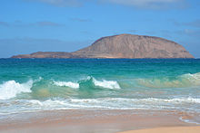
From Las Conchas beach on the island of La Graciosa, north of Lanzarote, there is a view of the uninhabited rock island of Montaña Clara, 1.65 kilometers west of here. It rises 256 meters above sea level and has an area of 1.48 square kilometers. Montaña Clara consists of the crater of a tuff cone that sunk into the sea to the north.
natural reserve

Montaña Clara, like the entire Chinijo archipelago, has been part of the nature reserve called Parque Natural del Archipiélago Chinijo since May 1986 . Within this natural park, the island, with the neighboring islands of Roque del Oeste and Roque del Este , has been specially protected since 1994 as Reserva Natural Integral de los Islotes .
The protection of this zone is higher than that of the rest of the nature park, so entering Montaña Clara is strictly forbidden. With the exception of the owner, because Montaña Clara is largely privately owned and has been offered for sale by a real estate company for nine million euros since 2007. As a buyer there is no question of private individuals, because the Spanish Council of Ministers declared in September 2007 the non-profit status of the islands of Montaña Clara and Alegranza , which are also for sale. There have already been negotiations with the Spanish state to include the island in its protected areas. In 2008, the island's 20-meter-wide coastal protection strip, which belongs to the public, was widened to 100 meters by the Coastal Protection Authority , as the Coastal Protection Act has provided for it since 1988. This significantly reduced the area to be sold privately.
Montaña Clara is, among other things, a refuge and breeding area for seabirds and the habitat of the Canary Shrew ( Crocidura canariensis ), which was described as a separate species in 1987 . The rabbits introduced in the 16th century, as on the other islands, were exterminated on Montaña Clara for nature conservation reasons. The island's flora has several endemic species.
Ownership
Montaña Clara is owned by the heirs of Mariano López Socas , who bought the island in 1957. He was later mayor of the Lanzarote municipality of Haría . In August 2007 the island was auctioned for an initial price of nine million euros. Negotiations on an agreement to take over the island by the state were unsuccessful. On August 29, 2007, it became public that the island's government would try to expropriate the island if there was no amicable agreement with the owner. Only the Spanish state can buy the islands into its protected areas, because in 2007 the Spanish Council of Ministers declared the islands of Montaña Clara and Alegranza , which are also privately owned, to be of public benefit .
The first 100 meters above the flood line have been public property since 2008, when the previous 20-meter-wide coastal protection strip, which the Coastal Protection Act has provided since 1988, was widened by the coastal protection authority COSTAS. This significantly reduced the area to be sold privately.
Web links
literature
- Eberhard Fohrer: Lanzarote . Michael Müller Verlag, Erlangen 2011. ISBN 978-3-89953-617-1
Individual evidence
- ↑ Spanish Statistics Office
- ↑ Costas draws borders on Alegranza and Montaña Clara. Island magazine Lanzarote 37 °, May 26, 2008, accessed on July 22, 2010 .
- ^ Juan Luis Rodríguez Luengo, Gorgonio Díaz Reyes: Manual del Cazador . Ed .: Consejería de Medio Ambiente y Ordenación Territorial. Gobierno de Canarias, Santa Cruz de Tenerife, Las Palmas de Gran Canaria, S. III 6 (Spanish, [1] [accessed September 19, 2016]).
- ↑ elmundo.es of August 29, 2007: El Gobierno expropiará la isla puesta en venta (Spanish) ; Retrieved September 9, 2014


