
Haría
| Haría municipality | |||
|---|---|---|---|
 View over the north of Lanzarote to the town of Haría
|
|||
| coat of arms | Map of the Canary Islands | ||

|
|
||
| Basic data | |||
| Autonomous Community : | Canary Islands | ||
| Province : | Las Palmas | ||
| Island: | Lanzarote | ||
| Coordinates | 29 ° 9 ′ N , 13 ° 29 ′ W | ||
| Height : | 270 msnm | ||
| Area : | 106.58 km² | ||
| Residents : | 5,123 (Jan 1, 2019) | ||
| Population density : | 48.07 inhabitants / km² | ||
| Postal code : | E – 35520 (Haría) E – 35541 ( Órzola ) E – 35542 ( Arrieta ) E – 35543 (Mala) |
||
| Municipality number ( INE ): | 35010 | ||
| administration | |||
| Mayor : | José Mariano Torres Stinga ( CC ) (as of 2010) | ||
| Address of the municipal administration: | Plaza de la Constitución, 1 35520 - Haría |
||
| Website : | www.ayuntamientodeharia.com | ||
| Location of the municipality | |||

|
|||

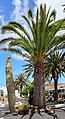
Haría is one of the seven churches of to Spain belonging Canary Island of Lanzarote . The capital of the municipality also bears this name. This is located in the valley of 1000 palm trees . A legend tells that whenever a girl was born in Haría, a new palm would grow.
history
Like other places in Lanzarote, Haría has been exposed to frequent invasions and pirate attacks. Almost all of the palm trees were burned down in an attack in 1586.
The classicist buildings on the Plaza de la Constitución date from the 19th century, when Haría was temporarily the seat of a constituent assembly. Since the 1950s, the place suffered from rural exodus. In the Franco era, many people left Haría for South America . Some of the abandoned houses are still empty today.
Townscape

The center of Haría is the elongated, shady Plaza León y Castillo with its Chinese fig and eucalyptus trees. At the eastern end of the square is the Iglesia de Nuestra Señora de la Encarnación , which was rebuilt in 1956 after severe storm damage. It is now a modern parish church. The Taller Municipal de Artesania handicraft center is located near the Plaza de la Constitución . Embroidery, baskets and capes are made here according to old traditions.
To the St. John's around ( Spanish Día de San Juan ) are placed for lack of flowers and leaves in place by the locals colorful salt carpets with different motifs on the streets. This happens during the day and you can watch people at work. Only the next day, a procession with St. Juan destroyed these salt paintings.
The grave of the island's artist and conservationist, César Manrique , is located in the Haría cemetery .
In 2003, the center of the village was placed under protection as a cultural asset of special interest (Bien de Interés Cultural - BIC), which ensured the protection of the existing. After 15 years, this protection expired at the beginning of 2018 and the island government did not apply for a new one on time. A new application is only possible in 2021.
Places of the community
The population figures in brackets (as of January 1, 2011):
- Arrieta (1,003 inhabitants)
- Charco del Palo (204 inhabitants)
- Guinate (36 inhabitants)
- Haría (1,135 inhabitants)
- Máguez (619 inhabitants)
- Mala (525 inhabitants)
- Órzola (288 inhabitants)
- Punta Mujeres (1,153 inhabitants)
- Tabayesco (127 inhabitants)
- Yé (113 inhabitants)
photos

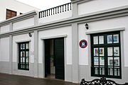
Haría Town Hall

Plaza León y Castillo
Manrique's grave in Haría cemetery

Iglesia de Nuestra Señora de la Encarnación

Iglesia de Nuestra Señora de la Encarnación (inside)
Library on Calle le Longuera


Individual evidence
- ↑ Cifras oficiales de población resultantes de la revisión del Padrón municipal a 1 de enero . Population statistics from the Instituto Nacional de Estadística (population update).
- ↑ Population figures see INE