
Bathymetry
As bathymetry (from the Greek. Βαθύς Bathys "low" and μέτρον métron "dimension") is defined as the measurement of topographical shape of the water beds , sea beds , as well as, for example, Seegründe . As a branch of hydrography and geodesy , bathymetry is used to generate terrain models and maps from which the depth profile of the oceans can be seen.
The most important tool of bathymetry is the echo sounder , especially the fan-shaped echo sounder , which is preferably used to measure the sea floor. However, since this measurement method is comparatively complex, a technology has recently been tested to obtain nautical charts from the data of radar satellites. These radar satellites can only image the surface of the water. Due to the gravity anomalies of submarine elevations and mountain ranges, the water level at these points is on average a few centimeters higher than at lower points. The water depth can be derived from precision measurements of the mean sea level.
Bathymetric map
A bathymetric map is a map of the sea floor or a lake with depth numbers, contour lines and possibly colored depth layers. The depth information is mostly related to a uniform reference level (e.g. sea chart zero ) to which the measured depth values are loaded .

Bathymetric map of the Arctic Ocean

Contour map of the Chiemsee (1888)

Contour map of the Tüttensee

Bathymetric map of the Caspian Sea (1858–1860)
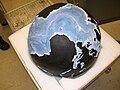
Bathymetric globe made by Bruce C. Heezen and Marie Tharp


.jpg)
See also
- Gebco - General Bathymetric Chart of the Oceans
- Earth / Dates and Numbers - The deepest ocean sinks
- List of sea lows
- Ridge of the sea
Web links
- Overview for sources of underwater terrain, data formats etc. (vterrain.org, English)
- Further collection of data sources